The Comeback of the Cuyahoga

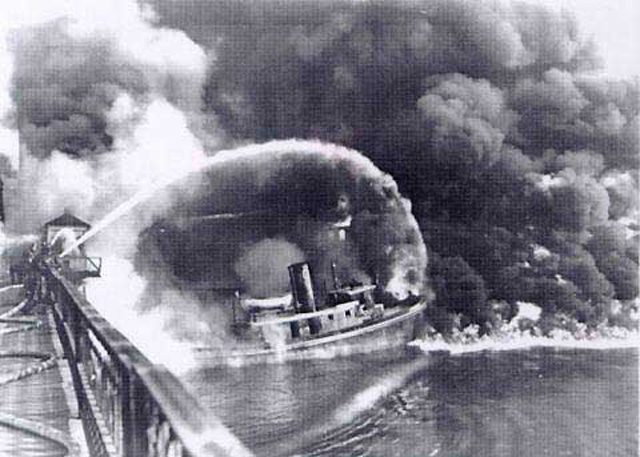
  • The famous photo of the Cuyahoga River fire that appeared in Time Magazine. The photo is not of the 1969 blaze, but rather of another fire on the river in 1952. (Photo courtesy of NOAA)

Four decades ago, one event changed how much
of the nation viewed environmental issues. The Cuyahoga River caught fire. Now a filmmaker is
releasing a documentary on the burning river and how it
became a catalyst for change. Julie Grant reports:

Transcript

Four decades ago, one event changed how much
of the nation viewed environmental issues. The Cuyahoga River caught fire. Now a filmmaker is
releasing a documentary on the burning river and how it
became a catalyst for change. Julie Grant reports:

People viewed things much differently in the middle of the
20th century than they do today. Pollution was an obscure
term, and smokestacks were a sign of prosperity.

“And like a good sign in the heavens, is the smoke from
these mills. A sign of the forgings and castings and sheets
and wire products to come.”

That old film sets the scene for a documentary called The
Return of the Cuyahoga River
.

It wasn’t just smokestacks, but sewer pipes the spewed out
gunk.

As mills manufactured paints, varnishes and oils, the color of
the river changed daily.

In the documentary, longtime river-man Wayne Bratton says
it could turn orange, red, blue or green – depending on the
color paint mills were making.

“Fifty years ago, the river boiled like a cauldron. This was all
very black, high petroleum content. Anoxic. And just
constantly bubbling like a stew on a stove.”

And prime for catching fire. But, 1969 was not the first time
the Cuyahoga caught on fire, and it wasn’t the only river to
burn.

Jonathon Adler is a professor at Case Western Reserve Law
School in Cleveland. In the film, he says that, at that time,
It wasn’t even surprising for a river to catch fire.

“It wasn’t just in Cleveland where we had industrial river
fires. This occurred on the Rouge River in Michigan, the
Chicago river, the Schuykill river in Philadelphia. The
Baltimore harbor. All of these areas caught fire due to the
collection of industrial waste and debris that at the time
wasn’t being cleaned up.”

The film-maker who’s responsible for the documentary on
the Cuyahoga, Larry Hott, says at the time it barely made
the news. It wasn’t until six weeks later when Time
Magazine ran an article about the fire in its new “Environment”
section.

“This was just after the moon shot, the first landing, and it
was also just after Ted Kennedy’s incident at Chapaquitic.
And this turned out to be the best selling magazine in time
magazine’s history. So millions of people saw this story.
And then people started talking about it – ‘what do you
mean, a river caught on fire?’”

After the Time Magazine article, the Cuyahoga became the
poster child of the environmental movement. In the
documentary, Professor Jonathon Adler says people were
astonished.

“One consequence of the Cuyahoga fire was greater political
pressure for additional federal legislation. And one of the
things that led to was the Clean Water Act of 1972, when the
federal government really increased dramatically its role in
helping to maintain water quality.”

The Clean Water Act and other federal regulations stopped
factories from dumping waste directly into rivers.

Many of the nation’s rivers are still being cleaned up. The
Cuyahoga still has problems, but it’s much cleaner than it
was a few decades ago. The documentary producer, Larry
Hott, says he recently took a boat into the river and was
surprised by the beauty of the Cuyahoga.

“You can save a river. It’s a symbol of hope. It gives us
hope – that after everything has gone wrong, after the cities
have burned and the river has burned, it can come back, and
we can be hopeful about the environment.

For The Environment Report, I’m Julie Grant.

Related Links

Forest Service Breaks Bank Fighting Fires

A new report from the US Department of Agriculture’s Inspector General shows the US Forest Service is spending too much money fighting fires. It suggests the feds get some help paying the bills from state governments. Mark Brodie reports:

Transcript

A new report from the US Department of Agriculture’s Inspector General shows the US Forest Service is spending too much money fighting fires. It suggests the feds get some help paying the bills from state governments. Mark Brodie reports:


The Inspector General report says the Forest Service went over budget four times in the last six years, spending more than a billion dollars in each of those years.


The service blames the cost increase in part on housing developments. They say more homes are being built farther into the forest.


Tom Harbour is the Forest Service’s Fire Chief.


“All of us treat protection of life as our certain first priority, and then treat the protection of communities and values on public lands as our second, and you bet it does make things more difficult.”


But some state foresters say the real difficulty comes from issues like changes in the weather and too much fire fuel on federal land. They say downed trees and excess brush make it difficult for the forest service to contain fires.


Both sides say they’ll bargain hard when it comes time to pay the bill for fighting fires.


For The Environment Report, I’m Mark Brodie.

Related Links

Study: The Human Factor and Wildfires

Wildfires account for a lot of property damage every year in the US, and forestry officials are constantly assessing how to predict when and where they will occur. One researcher says a largely overlooked predictor is the human factor. Brian Bull reports:

Transcript

Wildfires account for a lot of property damage every year in the US, and forestry officials are constantly assessing how to predict when and where they will occur. One researcher says a largely overlooked predictor is the human factor. Brian Bull reports:


Generally, vegetation and terrain are examined to figure out fire-prone areas. But Alexandra Syphard, a University of Wisconsin researcher, says most blazes happen along developments or roads, where forestland borders urban areas. Syphard says while she used southern California for her research model, her findings can be applied anywhere there is natural terrain along with man-made roads and structures.


“While the variables may differ a little bit in their degree of influence in different regions, you can still use these same kinds of methods to account for all of the factors that influence fires, as opposed to what a lot of people commonly do which is just simply looking at areas where fuels have accumulated.”


Syphard presented her research at the Third International Fire Ecology and Management Congress. She says variables such as terrain, climate, and vegetation still figure largely in active burns but that the human factor needs to be reviewed more closely.


For the Environment Report, I’m Brian Bull.

Related Links

STUDY: PBDEs FOUND IN SUPERMARKET FOOD

Researchers have found a potential toxin in our food. The Great Lakes Radio Consortium’s Mark Brush has an update on the ongoing concern over brominated flame retardants:

Transcript

Researchers have found a potential toxin in our food. The Great Lakes Radio
Consortium’s Mark Brush has an update on the ongoing concern over brominated
flame-retardants:


Brominated flame-retardants, or PBDEs are used to prevent fires in
everything from couch cushions to computer components. Several studies have
shown that there are higher amounts of these chemicals in Americans than in
people anywhere else in the world.


Researchers from the University of Texas recently tested 32 food items from major
supermarket chains in their area. They published their findings in the journal
Environmental Science and Technology. They found that all products with
animal fat in them, and one soy-based infant formula, were contaminated with PBDEs.


Dr. Arnold Schecter headed up the study. He says the human health effects have yet to
be understood:


“We don’t know whether these levels by themselves or in combination with
other chemicals could be causing human health effects. And, you know, we’re
particularly worried about the most sensitive population, before birth,
nursing infants, and the elderly, or people with special health problems.”


Experts say they’re concerned about these chemicals because they behave a
lot like PCBs, which are known to cause multiple health problems in humans.


For the Great Lakes Radio Consortium, I’m Mark Brush.

Related Links

Concern Grows Over Flame Retardant Chemicals

A class of potentially toxic chemicals, known as PBDEs, is being found in higher levels in people in North America. The chemicals are used to prevent fires in everything from couch cushions to televisions. The Great Lakes Radio Consortium’s Mark Brush has more:

Transcript

A class of potentially toxic chemicals, known as PBDE’s, is being found in
higher levels in people in North America. The chemicals are used to prevent
fires in everything from couch cushions to televisions. The Great Lakes
Radio Consortium’s Mark Brush has more:


PBDE’s are used extensively throughout North America. In Europe and Asia
the chemicals are hardly used at all for this purpose. To date, four studies have
indicated that North Americans have considerably higher levels of the
chemicals in their bodies, than do Europeans and Asians. The most recent
study tested the breast milk of 47 women in Texas.


Linda Birnbaum co-authored the study published in the journal Environmental Health
Perspectives. She says while these chemicals were created to save lives,
other chemicals should be developed that won’t be absorbed by human tissue:


“Personally I’m concerned about chemicals that persist and bio-accumulate.
They eventually get to a point be that they can be a problem.”


Some animal tests have shown that the chemicals can be toxic. That’s why the
European Union and the state of California enacted a ban on certain types of PBDE’s.


For the Great Lakes Radio Consortium, I’m Mark Brush.

Related Links

Geologists Mapping Underground Resources

Pull out a map and you’ll find the Great Lakes area holds resources that no other place can claim. The region is rich in lakes and forests and scenic views. But a road map just covers the surface. We know much less about what’s under the earth. Now, a team of geologists is working to map the resources under the ground. The Great Lakes Radio Consortium’s Erin Toner reports:

Transcript

Pull out a map and you’ll find the Great Lakes area holds resources that no other
place can claim.
The region is rich in lakes and forests and scenic views. But a road map just
covers the surface.
We know much less about what’s under the earth. Now, a team of geologists from the
Great
Lakes states is working to map the resources under the ground. The Great Lakes Radio
Consortium’s Erin Toner reports:


Look outside – look out your car window or into your backyard and try to erase
everything you
see. Take away the playgrounds and the concrete parking lots. Strip away the trees
and the grass
and the topsoil in your garden.


This is the way Kevin Kincare imagines the world. A picture of nothing except naked
landforms
– massive hills and cavernous valleys. All created by gigantic pieces of ice that
gouged and
ground their way down the globe from Canada. This would be the picture of Great
Lakes states
about 15-thousand years ago. It’s the picture Kincare is slowly putting down on paper.


“This is a big chunk of granite and you can see this one side is flat and looks
polished. The
glacier was moving across. There’s grooves right here. So this is the direction
the ice was
moving.”


Kincare is a glacial geologist with the Michigan Department of Environmental
Quality. Six years
ago, he helped start the Central Great Lakes Geologic Mapping Coalition. It’s a
group of
geologists from four states – Michigan, Indiana, Illinois and Ohio – and the U.S.
Geological
Survey. They’re working to put together a 3-D digital map of the region’s glacial
geology.
They’ll map everything down to the bedrock, which can be hundreds of feet below the
Earth’s
surface.

The first step in geologic mapping is compiling information from local maps. After
that it’s out
to the field.


At Tacy Brother’s Gravel Pit, a massive machine is sorting big scoops of earth into
piles of sand,
gravel and rocks.


Kincare is now working on mapping a small county on Lake Michigan. He says looking
at a
gravel pit is like looking at nature’s record of thousands of years of changes to
the planet’s
surface.


“That starts to pull the whole story together. How the ice retreated across the
county from east to
west and where all the rivers that were carrying the melting glacier ice and
depositing thick
sections of sand, and where the glacial lakes were, where all the silt and clay was
dropping out.”


Geologists say one of the most important uses for the maps is locating water
resources.
Nationally, Michigan ranks first in the number of people who use household wells to
get their
drinking water. Illinois, Ohio and Indiana rank among the top 15 in the nation for
household
water well use.


Gary Witkowski’s job is to protect the environment in his county in southwest
Michigan. He says
the first step in protecting groundwater is knowing exactly where it is.


“It’d be a tremendous help for us if we could just go to a resource like this and
pull that
information. Not only to us, but, I mean, even to the developer, it would be a
major plus that they
could look at.”


Knowing exactly what’s under the ground also helps planners build in the right
places. And it
helps them avoid building in the wrong places. For example, planners can put
neighborhoods
close to supplies of groundwater. They can discourage development on land rich in
minerals and
construction materials, such as sand and gravel. And they can make sure they don’t
build
industrial plants in places that are especially vulnerable to pollution.


Dennis O’Leary is with the U.S. Geological Survey. He’s helping Kevin Kincare with
the map.


“Those kinds of decisions that involve competing interests really can’t be made
rationally unless
there’s a body of knowledge, of fact, that relates to just what the question’s all
about and that’s
what these maps provide.”


But it could be awhile before people have access to maps this detailed. The four
states in the
mapping coalition and the Geological Survey all have to share 500-thousand dollars a
year for the
project. That means Kevin Kincare can map only one county every three years. It
would take
two centuries just to finish his state.


“We’d have to have a lot of medical breakthroughs for me to finish this project.”


Kincare says the maps are too important to wait that long. He says they need
20-million-dollars a
year from Congress. With that money, they could put together a complete geologic
map of the
Great Lakes region in about 16 years. Kincare says he’s not optimistic they’ll get
that kind of
money.


For the Great Lakes Radio Consortium, I’m Erin Toner.

Forests for Lumber or Wildlife?

  • Loggers and environmentalists fight continually over the use of national forests. Managers at many national forests around the country are developing new long-range plans. (Photo by Stephanie Hemphill)

Loggers and environmentalists are in a continual fight over the use of national forests. One of their battlegrounds is the long-range planning process. Every ten to fifteen years, the U.S. Forest Service designs a new plan for each national forest. Right now, several forests in the Northwoods are getting new plans. The Forest Service says it’s paying more attention to biodiversity, and wants to encourage more old growth forests. Critics on the environmental side say the new plans are just business as usual. Loggers say they still can’t cut enough trees. The Great Lakes Radio Consortium’s Stephanie Hemphill reports:

Transcript

Loggers and environmentalists are in a continual fight over the use of
national forests. One of their battlegrounds is the long-range
planning process. Every ten to fifteen years, the U.S. Forest Service
designs a new plan for each national forest. Right now, several
forests in the Northwoods are getting new plans. The Forest Service
says it’s paying more attention to biodiversity, and wants to encourage
more old growth forests. Critics on the environmental side say the
new plans are just business as usual. Loggers say they still
can’t cut enough trees. The Great Lakes Radio Consortium’s Stephanie
Hemphill reports:


(sound of car door closing, footsteps in woods)


Jerry Birchem is a logger. He’s visiting one of his harvest sites on
land owned by St. Louis County, in northeastern Minnesota. The highest
quality wood will be turned into wooden dowels… other logs will go to a
lumber mill… the poorest quality will be turned into paper.


Birchem tries to get the highest possible value from each tree. He says in the last ten
years, the price of trees has tripled.


“We have to pay more for timber and the mills want to pay less, and we’re caught in the
middle of trying to survive in this business climate.”


Birchem likes buying timber from the county, like at this logging site. He hardly ever
cuts trees from the national forest anymore. He’d like to, but the Forest Service doesn’t
make much of its land available for logging. The agency says it doesn’t have enough staff
to do the environmental studies required before trees can be cut on federal land.


Jerry Birchem says loggers need the Forest Service to change that.


“You know there needs to be processes set in place so you know, it doesn’t take
so long to set up these timber sales. I mean, they’ve got to go through so
many analyses and so many appeals processes.”


Birchem says it should be harder for environmental groups to get in the way of timber
sales. But not everybody agrees with Birchem.


Clyde Hanson lives in Grand Marais, on the edge of Lake Superior. He’s an active
member of the Sierra Club.


He says it’s true loggers are taking less timber off federal lands in recent
years. But he says the Forest Service still isn’t protecting the truly special
places that deserve to be saved.


He says a place like Hog Creek should be designated a wilderness area, where no trees
can be cut.


(sound of creek, birds)


“Very unique mixture, we must be right at the transition between two types of forest.”


Red pine thrive here, along with jackpine and tamarack. It’s rough and swampy country,
far from roads. So far, loggers have left these trees alone.


But with the value of trees skyrocketing, Hanson says the place will be logged eventually.


Forest Service planners made note of the fact that the Hog Creek area is relatively
untouched by humans. They could have protected it, but they decided not to.


“And we think that’s a mistake, because this is our last chance to protect wilderness and
provide more wilderness for future generations. If we don’t do it now, eventually there’ll
be enough roads or enough logging going on in these places that by the next forest plan
it’ll be too late.”


But the Forest Service says it is moving to create more diversity in the
woods. It wants a forest more like what nature would produce if left
to her own devices.


The agency says it will reduce the amount of aspen in the forest. Aspen has been
encouraged, because it grows fast. When it’s cut, it grows back quickly, so loggers and
paper companies can make more money.


The trouble is, an aspen forest only offers habitat for some kinds of animals,
such as deer and grouse. Other animals, especially songbirds, need older trees to
live in.


So the Forest Service wants to create more variety in the woods, with more old trees than
there are now. But how to get the forest from here to there, is the problem.
Duane Lula is one of the Forest Service planners. He says fires and windstorms are nature’s way of producing
diverse forests. They sweep the woods periodically, killing big stands of older trees, and
preparing the soil for pines and other conifers. Jackpines, for instance, used to be more
common in the northwoods. Lula says the only practical way for man to mimic nature is
by cutting trees down.


“We can’t have those fires anymore just because people live here, there are private
homes here. There’s no way that we could replicate those fires. Timber management is one way of regenerating those jackpine stands in
lieu of having major fires.”


But Lula says the main purpose of timber cutting in the new plan is to move the forest
toward the diversity the agency wants, not to produce wood. And he says that shows the
Forest Service is looking at the woods in a new way.


“The previous plan tended to be very focused on how many acres you were going to
clearcut, how much timber you were going to produce, how much wildlife habitat you
were going to produce, and this one is trying to say, if we have this kind of desired
condition on the ground that we’re shooting for, then these other things will come from
that.”


As it does in the planning process in other national forests around the Great Lakes, the
Forest Service will adjust the plan after hearing from the public. Loggers,
environmentalists, and everyone else will have a chance to have their say. A final version
will be submitted to the Regional Forester in Milwaukee early next year. It could then
face a challenge in court.


For the Great Lakes Radio Consortium, I’m Stephanie Hemphill.

Related Links

City Ignites Green Space

Many cities create parks to try to incorporate green space into theirurban landscapes. But maintaining them can be expensive and laborintensive. Now, one city has created a unique solution–addingnaturalbeauty while saving money. The Great Lakes Radio Consortium’s Tasya Rosenfeld has the story:

The Prairie Pioneer

For almost forty years, Dr. Robert Betz searched the railroad tracks and
back roads of the Midwest for remnants of the nearly extinct tall-grass
prairie. Along the way, he helped define and popularize a new
environmental movement on the rise throughout the Great Lakes and the
country—a movement called ecological restoration. The Great Lakes Radio
Consortium’s Alex Blumberg has this report: