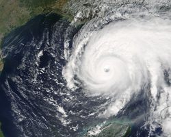
Hurricane Rita in the Gulf of Mexico in 2005. (Photo courtesy of
Jeff Schmaltz, NASA/GSFC )
Hurricane season starts soon. Experts predict an active season with four “major” hurricanes. What happens if a storm hits while there’s still an oil spill in the Gulf of Mexico? Tanya Ott reports.
Transcript
Hurricane season starts soon. Experts predict an active season with four “major” hurricanes. What happens if a storm hits while there’s still an oil spill in the Gulf of Mexico? Tanya Ott reports.
If a tropical storm hits while there’s still oil in the water, it could disastrous for the coastline and several miles inland. Mark Wysocki is a Cornell University climatologist.
“All that oil would get into the marshlands and some of the homeowners’ properties and so forth and that would make it very difficult then to remove that oil from those types of locations.”
When Katrina hit Louisiana it destroyed some of the oil distributor piping, and they’re still cleaning up in some of the wetland areas.
Wysocki says the one upside is that oil makes it harder for water to evaporate. Tropical storms need evaporation to build strength. So an oil spill might actually keep storms smaller.
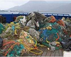
Marine researcher Marcus Eriksen says the plastic packaging that wraps nearly all consumer products is killing some marine animals.(Photo courtesy of the NOAA Marine Debris Program)
A giant field of plastic debris is floating in the middle of the northern Pacific Ocean. Now researchers are finding more of these garbage patches in other Oceans. Mark Brush has more:
Transcript
A giant field of plastic debris is floating in the middle of the northern Pacific Ocean. Now researchers are finding more of these garbage patches in other Oceans. Mark Brush has more:
Researchers say there are ocean currents that sort of swirl around like water in a toilet bowl. There called oceanic gyres.
The Algalita Marine Research Foundation was one of the groups that documented the problem in the North Pacific Ocean. This year they sailed to the gyres in the North Atlantic and in the Indian Ocean.
They found miles and miles of plastic fishing line, milk crates, spoons and forks, and bits of plastic bags.
Marcus Eriksen is with the group:
Eriksen: I challenge you to walk into Wal-Mart or a K-Mart and find a product that’s not made from plastic, packaged or labeled with plastic. And we’re finding more and more of this debris being lost onto the ground washing down rivers and streams out to sea.
Eriksen says the plastic is killing some marine animals. Fish, birds, turtles, and whales get tangled up in the mess – or they mistake it for food.
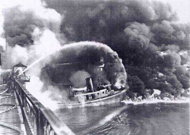
The famous photo of the Cuyahoga River fire that appeared in Time Magazine. The photo is not of the 1969 blaze, but rather of another fire on the river in 1952. (Photo courtesy of NOAA)
Four decades ago, one event changed how much
of the nation viewed environmental issues. The Cuyahoga River caught fire. Now a filmmaker is
releasing a documentary on the burning river and how it
became a catalyst for change. Julie Grant reports:
Transcript
Four decades ago, one event changed how much
of the nation viewed environmental issues. The Cuyahoga River caught fire. Now a filmmaker is
releasing a documentary on the burning river and how it
became a catalyst for change. Julie Grant reports:
People viewed things much differently in the middle of the
20th century than they do today. Pollution was an obscure
term, and smokestacks were a sign of prosperity.
“And like a good sign in the heavens, is the smoke from
these mills. A sign of the forgings and castings and sheets
and wire products to come.”
That old film sets the scene for a documentary called The
Return of the Cuyahoga River .
It wasn’t just smokestacks, but sewer pipes the spewed out
gunk.
As mills manufactured paints, varnishes and oils, the color of
the river changed daily.
In the documentary, longtime river-man Wayne Bratton says
it could turn orange, red, blue or green – depending on the
color paint mills were making.
“Fifty years ago, the river boiled like a cauldron. This was all
very black, high petroleum content. Anoxic. And just
constantly bubbling like a stew on a stove.”
And prime for catching fire. But, 1969 was not the first time
the Cuyahoga caught on fire, and it wasn’t the only river to
burn.
Jonathon Adler is a professor at Case Western Reserve Law
School in Cleveland. In the film, he says that, at that time,
It wasn’t even surprising for a river to catch fire.
“It wasn’t just in Cleveland where we had industrial river
fires. This occurred on the Rouge River in Michigan, the
Chicago river, the Schuykill river in Philadelphia. The
Baltimore harbor. All of these areas caught fire due to the
collection of industrial waste and debris that at the time
wasn’t being cleaned up.”
The film-maker who’s responsible for the documentary on
the Cuyahoga, Larry Hott, says at the time it barely made
the news. It wasn’t until six weeks later when Time
Magazine ran an article about the fire in its new “Environment”
section.
“This was just after the moon shot, the first landing, and it
was also just after Ted Kennedy’s incident at Chapaquitic.
And this turned out to be the best selling magazine in time
magazine’s history. So millions of people saw this story.
And then people started talking about it – ‘what do you
mean, a river caught on fire?’”
After the Time Magazine article, the Cuyahoga became the
poster child of the environmental movement. In the
documentary, Professor Jonathon Adler says people were
astonished.
“One consequence of the Cuyahoga fire was greater political
pressure for additional federal legislation. And one of the
things that led to was the Clean Water Act of 1972, when the
federal government really increased dramatically its role in
helping to maintain water quality.”
The Clean Water Act and other federal regulations stopped
factories from dumping waste directly into rivers.
Many of the nation’s rivers are still being cleaned up. The
Cuyahoga still has problems, but it’s much cleaner than it
was a few decades ago. The documentary producer, Larry
Hott, says he recently took a boat into the river and was
surprised by the beauty of the Cuyahoga.
“You can save a river. It’s a symbol of hope. It gives us
hope – that after everything has gone wrong, after the cities
have burned and the river has burned, it can come back, and
we can be hopeful about the environment.
Grassland prairie flowers from Weldon Spring, part of the Department of Energy's restoration effort to control erosion and add aesthetic beauty to the area. (Photo courtesy of U.S. Department of Energy)
Birdseye view of Weldon Spring disposal cell, which contains 1.48 million cubic yards of radioactive waste. (Photo courtesy of U.S. Department of Energy)
Another view of the disposal cell. The cell covers a massive 45 acres in Weldon Spring. (Photo courtesy of U.S. Department of Energy)
Across the U.S., there are more than 100 sites contaminated by radioactive waste from the nation’s nuclear weapons programs.
The government is trying to return these Cold War relics to safe and useful purposes. Some of these once toxic zones are being treated much like public parks. The GLRC’s Kevin Lavery visited one that was recently opened to the public:
Transcript
Across the US, there are more than 100 sites contaminated by radioactive waste from the
nation’s nuclear weapons programs. The government is trying to return these Cold War
relics to safe and useful purposes. Some of these once toxic zones are being treated much
like public parks. The GLRC’s Kevin Lavery recently visited one that was recently
opened to the public…
A thick grove of trees opens up to a clearing that reveals a white mound of limestone
rock. It rises like a tomb from some long-forgotten civilization, were it not for the water
towers and golf courses on the horizon.
Mike Leahy and his 9-year-old son Cameron came to this rock dome to catch the view
atop its 75 foot summit. But the real attraction was what they did not see:
“We read the sign and saw what was buried and how they did it, and – it’s kind of
disturbing, what’s in there.”
Beneath their feet lay more than a million cubic yards of spent uranium, asbestos and
PCB’s. The 45 acre mound is a disposal cell, where the government buried thousands of
barrels and tons of debris. That history didn’t bother young Cameron:
“It’s really cool. They keep all that nuclear waste under all that and it can’t harm
anybody.”
The Weldon Spring site, 30 miles west of St. Louis, Missouri began during World War
Two as an Army TNT factory. In the 1950’s, the plant refined yellow cake uranium for
later use in nuclear weapons. All that stopped in 1966 and all the radioactive waste just
sat there. Weldon Spring became an EPA Superfund site in 1987. After a 900 million
dollar cleanup, the site was opened to tourists in 2002.
(Sound of frogs)
Today, frogs sing in a native prairie at the foot of the cell. In April, officials opened a
hiking trail adjacent to a once-radioactive landfill. The route connects to a state park.
Weldon Spring is not a park per se, but project manager Yvonne Deyo says urban sprawl
prompted them to think like one:
“There’s subdivisions and lots of infrastructure going in…and that just kind of hits home
how important green space is, and that’s kind of what we’re trying to do a little bit of
here at the site.”
Weldon Spring is one of about 100 such sites the Department of Energy is converting to
what it calls “beneficial re-use.” Many are becoming recreational venues. Another
closed uranium plant near Cincinnati is adding horseback riding trails. In Wayne, New
Jersey, a former thorium processing facility is becoming a baseball field. And a national
wildlife preserve is in the works at Rocky Flats, the site outside Denver that made the
plutonium cores of nuclear warheads.
The Department of Energy says Weldon Spring is safe for visitors – though some residual
contamination remains.
(Sound of Burgermeister Spring)
Burgermeister Spring runs through a 7-thousand acre state reserve adjacent to the site.
This is where uranium-laced groundwater from Weldon Spring rises to the surface.
Though the spring exceeds the EPA’s drinking water quality standard, there’s no warning
sign here. Officials say the contamination is so low that it poses no immediate public
hazard. The spring feeds into one of the most popular fishing lakes on the property.
Most visitors are surprised to hear that:
“Huh.”
Jeff Boeving fishes for bass four or five times a month:
“(Does that concern you to hear that?) Yeah – absolutely…I mean, they’ve got a great
area out here and they’re kind of messing it up if they’re going to have contaminants, you know, going into it.”
The government’s vision of post-nuclear playgrounds is not without its critics. Arjun
Makhijani heads the Institute for Energy and Environmental Research in Takoma Park,
Maryland. He says recreational sites near urban development zones risk losing their
original purpose:
“Institutional memory tends to be very short; after 30, 40, 50 years people forget, they
begin to develop the land, and pretty soon you could have houses, farms and schools in
the area. So it’s not necessary that it will stay recreational forever.”
Recreation is only one option the Department of Energy is considering for all of its sites.
In the last two years, the agency’s budget has doubled with the addition of nearly a dozen
radioactive properties. Officials say Congress has so far supported its fiscal requests.
And with the future of a proposed permanent nuclear waste site at Yucca Mountain still
in doubt, even more tax dollars will likely be spent converting the nuclear dumps in
America’s backyards to a place where families play.
Environmental issues may slow the re-development of
some of the military bases that are scheduled to close over the next several months. The Great Lakes Radio Consortium’s Chuck Quirmbach reports:
Transcript
Environmental issues may slow the re-development of some of the military bases that are
scheduled to close over the next several months. The Great Lakes Radio Consortium’s Chuck
Quirmbach reports:
The defense department says many of the military bases to be shut down may have leaking fuel
tanks, construction debris, heavy metal contamination and other problems. The department’s
office of economic adjustment works with communities to sort through the long list of legal,
financial and environmental issues. These issues must be solved before a base can be re-developed.
Spokesperson Lynn Boese promises the defense department won’t just abandon the sites.
“The federal government can’t transfer the property until it’s been remediated so that there’s no
danger to human health or the environment.”
But Boese cautions that the feds typically only pay for clean up to so-called similar use standards.
If the bases are re-used for things such as homes or day care centers more clean-up would be
needed… and those costs could be passed on to someone else.
Life in the suburbs is idyllic to some people... (Photo by Bon Searle)
...and many rats, now that the sewers have been flooded. (Photo by Tamara Bauer)
Unusually heavy rains this summer are partly to blame
for rats pouring out of the sewers in droves all over the country, and the nasty vermin are relocating to some of the most pristine
neighborhoods. The Great Lakes Radio Consortium’s Joyce
Kryszak explains what caused the rat invasion and
what’s being done to evict them:
Transcript
Unusually heavy rains this summer are partly to blame for rats pouring out of the sewers
in droves all over the country. And the nasty vermin are relocating to some of the most
pristine neighborhoods. The Great Lakes Radio Consortium’s Joyce Kryszak explains what
caused the rat invasion and what’s being done to evict them:
Piercing blue autumn skies and billowing white clouds drift across the chimneys of this modest,
but perfectly manicured suburb. There aren’t even many leaves crunching under foot. Town workers
have already come and vacuumed them all away. But there’s a nasty little secret scurrying under
the porches and behind the garden sheds in this Western New York town. County Sanitation Chief
Peter Tripi takes us for a peek.
“Can you see the teeth marks here? That’s actually rat gnaw marks. And there’s the garbage bag.
And that’s what we found when we went to this property.”
Now, you might be thinking that we trudged through derelict grass and scattered debris to find
these rat clues. Nope. This is a gorgeous, manicured yard – with not a blade of grass out of
place. But Tripi says rats aren’t choosy.
“You would never think by looking side to side that there would be a rat problem in this yard.
Doesn’t matter what neighborhood you live in, or how much money you’ve got. There’s no difference.
They just like your food.”
And you’d be surprised where rats can find food. A garbage can left even briefly uncovered, a
neglected bird feeder, uhhh… dog feces… and even a compost pile.
“Absolutely. This is a rat condo. It’s a grass-clipping compost pile that basically housed rats
to go a hundred yard radius all the way around to the different houses.”
Tripi says rats had to get creative with their housing. A summer of extremely heavy rains drove
the out of the sewers and into some previously rat-free neighborhoods. And with the West Nile
virus killing off millions of birds, the rats have less competition for the food they’re finding
above ground. The consequence is a virtual rat infestation all the way from New York and Illinois
to Virginia, Michigan and L.A. In Kenmore, there have been four thousand rat complaints – nearly
double last year.
(Sound of garbage truck)
Of course, none of this is news to the garbage collectors. They see the problem up close and
personal. Twenty-year veteran Louie Tadaro says this past summer is the worst he’s ever seen.
“Across the street there’s an alleyway and there had to be like ten of them in there, And we
started chasing them with garbage cans trying to kill them, but we couldn’t. By the time we
got there they just split.”
The problem is, they don’t split for long. Vector Control Chief Tripi says now that the rats
have relocated from the sewers to upscale accommodations, they kind of like it.
“And what that means is that they want to live with us. They want to be near our garbage and
our bird feeders. The problem with that is that rats carry diseases.”
We all know about stuff like typhus and the bubonic plague. But there are emerging diseases,
such as a pet-killer called Leptospiroris. It’s killing dogs all across the country. Tripi
says they need to get rid of the rats before the disease starts spreading to humans. So, his
team is taking the rats on, one yard at a time.
Tripi and his Vector control team set rat traps, they fill bait boxes with poison, and – when
they have to – they issue citations to residents who don’t heed the town’s new “rat control rules.” Covered garbage cans only. Clear away all brush. Clean up scattered bird seed and dog feces. Slowly, the rules seem to be working.
(sound of Tripi looking into rat trap)
Still Tripi says it’s mostly educational warfare. And he says now – heading into winter – is the
best time to nip the problem. If the rats get cozy, not only will they stay, they will multiply.
Fully nourished, one adult rat can breed up to sixty baby rats a year.
“The adult rat can live on a little bit of food, but he can’t procreate unless he has a lot of
food source. And they can’t live through the winter unless they’re warm and fattened up.”
So now is the time to – quite literally – put a lid on it. Keep those garbage cans covered, unless
you want some uninvited furry guests this winter, and many, many more come spring.
For the Great Lakes Radio Consortium, I’m Joyce Kryszak.
Sewage overflows during heavy rains have long been implicated in illnesses in people. For the first time, the Environmental Protection Agency has come up with an estimate of just how many people are getting sick from swimming at contaminated beaches. The Great Lakes Radio Consortium’s Tracy Samilton reports:
Transcript
Sewage overflows during heavy rains have long been implicated in
illnesses in people. For the first time, the Environmental Protection
Agency has come up with an estimate of just how many people are getting
sick from swimming at contaminated beaches. The Great Lakes Radio
Consortium’s Tracy Samilton reports:
The EPA estimates that somewhere between 3,500 and 5,500 beachgoers get sick
every year when untreated sewage is flushed into rivers, streams and lakes
by heavy rains. The EPA’s Ben Grumbles says the report is another reason
for cities to fix their aging sewage systems – despite the high cost.
“And it can literally add up to hundreds of millions, a couple of billion dollars, for
very large cities, to fix the problem for the long-term.”
Grumbles says many communities can avoid that bigger expense by investing
in new technologies to better manage existing systems – and keeping pipes
well-maintained and free of debris.
Environmental groups say they hope legislators are listening. Congress just reduced
the fund from which communities can get loans for sewer projects by 500 million dollars.
For the Great Lakes Radio Consortium, I’m Tracy Samilton.
Two-hundred years ago this May, Meriwether Lewis and William Clark started up the Missouri River on a two-year journey into the American West. As America commemorates the bicentennial of the expedition, hundreds of volunteers are cleaning up the Missouri. The Great Lakes Radio Consortium’s Kevin Lavery reports:
Transcript
Two-hundred years ago this May, Meriwether Lewis and William Clark started up the
Missouri River on a two-year journey into the American West. As America
commemorates the bicentennial of the expedition, hundreds of volunteers are cleaning up
the Missouri. The Great Lakes Radio Consortium’s Kevin Lavery reports:
A troupe portraying Lewis and Clark’s Corps of Discovery is retracing the explorers’
path. The real journey starts when they leave Illinois and take their keelboat up the
Missouri River as it meanders through the state of Missouri.
But…the Missouri is not as clean as the day Lewis and Clark first saw it. With the re-
enactors and their flotilla coming, some local volunteers want to do some cleaning up
ahead of time. They’re launching what could be the biggest clean-up ever on the Big
Muddy.
(sound of lapping water)
John Brady and Jeff Barrow are with Missouri River Relief, a grassroots nonprofit that
began cleaning the banks of the Missouri three years ago. Now, they’re embarking on
their most ambitious project yet: eight massive daylong cleanups that will stretch into
June. The idea is to stay two weeks ahead of the flotilla, clearing away any eyesores
along its cruise upriver.
Barrow says they’ve seen their share of garbage clogging the Missouri:
“Everything from cars and truck bodies, you find a lot of freezers and refrigerators, you
find tons of Styrofoam, plastic…we found a piano once.”
(sound of boat motor starting)
Barrow and Brady are scouting the river in search of places where debris piles up. As the
advance team, their job is to place markers in heavy trash areas so the coming clean-up
crews know where to start. Just a few hundred yards out, Brady spots a small pocket of
trash. But he knows that what he sees on the shore is only a fraction of what’s hidden in
the trees:
“So, when you go out scouting you spot the obvious stuff that you can see from the
riverbank, and then you go to the spots where you know that it’s more likely that stuff
accumulates. For example, brushy spots on the outside of bends. And you get out and
look, and if it’s a good heavy spot, you schedule a crew to come in there and work it.”
Barrow guns the motor and heads for the spot where the Missouri flows into the
Mississippi. The two currents blend into a broad waterway. On the far bank of the
Mississippi, green trees give way to rusty machinery and industry on the Illinois bank:
Barrow: “Do we have our passport for Illinois here?” (laughs)
Barrow says this area will get special attention:
“Right here is where they’re going to kick off the Lewis and Clark flotilla. See this gravel
beach? So they’re expecting 2,000 people to be here, and we’re going to be cleaning up
this area, get all this driftwood out of there…you see the trash that’s up there.”
Preparing the site for that many people will take a small army of volunteers. But the
excitement of the Lewis and Clark bicentennial should make that an easier job than usual.
Evan McFarland belongs to the River Kids…a non-profit group made up of some 40 St.
Louis fourth-graders that began cleaning local creeks last fall. He’s enthusiastic about the
environmental benefits of a cleaner river. But Evan also sees a public relations benefit.
With potentially thousands of foreign tourists coming to the U.S. for the bicentennial
events, Evan thinks the time is right to showcase the Missouri:
“Well, I hope that they would be very excited and maybe compare where they came from,
maybe a river or a lake to the Missouri River…and maybe if they’ve already been here
before, see how it’s improved, and say hey…this is a pretty clean river.”
The band of volunteers will start at the confluence of the Missouri and Mississippi before
the flotilla sets sail May 14th. They’ll steadily move upstream, capping their efforts with
a grand finale cleanup in Kansas City in June.
For the Great Lakes Radio Consortium, I’m Kevin Lavery.
Pull out a map and you’ll find the Great Lakes area holds resources that no other place can claim. The region is rich in lakes and forests and scenic views. But a road map just covers the surface. We know much less about what’s under the earth. Now, a team of geologists is working to map the resources under the ground. The Great Lakes Radio Consortium’s Erin Toner reports:
Transcript
Pull out a map and you’ll find the Great Lakes area holds resources that no other
place can claim.
The region is rich in lakes and forests and scenic views. But a road map just
covers the surface.
We know much less about what’s under the earth. Now, a team of geologists from the
Great
Lakes states is working to map the resources under the ground. The Great Lakes Radio
Consortium’s Erin Toner reports:
Look outside – look out your car window or into your backyard and try to erase
everything you
see. Take away the playgrounds and the concrete parking lots. Strip away the trees
and the grass
and the topsoil in your garden.
This is the way Kevin Kincare imagines the world. A picture of nothing except naked
landforms
– massive hills and cavernous valleys. All created by gigantic pieces of ice that
gouged and
ground their way down the globe from Canada. This would be the picture of Great
Lakes states
about 15-thousand years ago. It’s the picture Kincare is slowly putting down on paper.
“This is a big chunk of granite and you can see this one side is flat and looks
polished. The
glacier was moving across. There’s grooves right here. So this is the direction
the ice was
moving.”
Kincare is a glacial geologist with the Michigan Department of Environmental
Quality. Six years
ago, he helped start the Central Great Lakes Geologic Mapping Coalition. It’s a
group of
geologists from four states – Michigan, Indiana, Illinois and Ohio – and the U.S.
Geological
Survey. They’re working to put together a 3-D digital map of the region’s glacial
geology.
They’ll map everything down to the bedrock, which can be hundreds of feet below the
Earth’s
surface.
The first step in geologic mapping is compiling information from local maps. After
that it’s out
to the field.
At Tacy Brother’s Gravel Pit, a massive machine is sorting big scoops of earth into
piles of sand,
gravel and rocks.
Kincare is now working on mapping a small county on Lake Michigan. He says looking
at a
gravel pit is like looking at nature’s record of thousands of years of changes to
the planet’s
surface.
“That starts to pull the whole story together. How the ice retreated across the
county from east to
west and where all the rivers that were carrying the melting glacier ice and
depositing thick
sections of sand, and where the glacial lakes were, where all the silt and clay was
dropping out.”
Geologists say one of the most important uses for the maps is locating water
resources.
Nationally, Michigan ranks first in the number of people who use household wells to
get their
drinking water. Illinois, Ohio and Indiana rank among the top 15 in the nation for
household
water well use.
Gary Witkowski’s job is to protect the environment in his county in southwest
Michigan. He says
the first step in protecting groundwater is knowing exactly where it is.
“It’d be a tremendous help for us if we could just go to a resource like this and
pull that
information. Not only to us, but, I mean, even to the developer, it would be a
major plus that they
could look at.”
Knowing exactly what’s under the ground also helps planners build in the right
places. And it
helps them avoid building in the wrong places. For example, planners can put
neighborhoods
close to supplies of groundwater. They can discourage development on land rich in
minerals and
construction materials, such as sand and gravel. And they can make sure they don’t
build
industrial plants in places that are especially vulnerable to pollution.
Dennis O’Leary is with the U.S. Geological Survey. He’s helping Kevin Kincare with
the map.
“Those kinds of decisions that involve competing interests really can’t be made
rationally unless
there’s a body of knowledge, of fact, that relates to just what the question’s all
about and that’s
what these maps provide.”
But it could be awhile before people have access to maps this detailed. The four
states in the
mapping coalition and the Geological Survey all have to share 500-thousand dollars a
year for the
project. That means Kevin Kincare can map only one county every three years. It
would take
two centuries just to finish his state.
“We’d have to have a lot of medical breakthroughs for me to finish this project.”
Kincare says the maps are too important to wait that long. He says they need
20-million-dollars a
year from Congress. With that money, they could put together a complete geologic
map of the
Great Lakes region in about 16 years. Kincare says he’s not optimistic they’ll get
that kind of
money.
For the Great Lakes Radio Consortium, I’m Erin Toner.
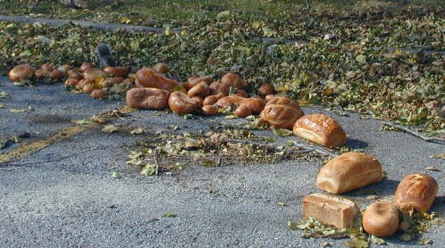
This bread was dumped at a park along a Great Lakes beach for the gulls, geese, and squirrels that live there. Beach visitors often assume high bacteria levels that close beaches to swimmers are solely due to sewer overflows, but animals that defecate in the area also contribute to the problem.
This past summer beaches around the Great Lakes were closed in record numbers because of high bacteria counts. One government study indicates part of the problem might be animal feces, but the public does not seem to be aware that of the connection. The Great Lakes Radio Consortium’s Lester Graham reports:
Transcript
This past summer beaches around the Great Lakes were closed in record numbers
because of high bacteria counts. One government study indicates part of the problem
might be animal feces, but the public does not seem to be aware that of the connection.
The Great Lakes Radio Consortium’s Lester Graham reports:
High levels of bacteria in the water can make swimmers sick. Cameron Davis is with the
watchdog group, the Lake Michigan Federation. He says more can be done to stop the
contamination if sewer plants are improved and if beach visitors were more aware that
leaving food waste and feeding gulls and geese adds to the problem. That’s because the
birds defecate more, causing higher levels of bacteria along the shore.
“So, we’ve got the sewage treatment agencies saying ‘Oh, no. It’s the geese and the
gulls,’ and we’ve got the people feeding the birds saying ‘Oh, no. It’s sewage treatment
plants.’ So, you can see, it’s a combination of sources and there are things — I don’t care
what anybody says — there are things we can do to help solve the problem with all those
different sources.”
Davis says local governments need to start identifying and eliminating those sources of
beach contamination, starting with improving sewer plants and getting people to clean up
after their visits and to stop feeding wildlife at the beaches.
For the Great Lakes Radio Consortium, this is Lester Graham.
 Hurricane Rita in the Gulf of Mexico in 2005. (Photo courtesy of Jeff Schmaltz, NASA/GSFC )