After years of delay and scandal, the Army Corps of Engineers is getting ready to release its final report on how to best manage the Upper Mississippi River. The report will influence policy on the river for the next 50 years. The Great Lakes Radio Consortium’s Katherine Glover has the story:
Transcript
After years of delay and scandal, the Army Corps of Engineers is getting ready to release its final
report on how to best manage the Upper Mississippi River. The report will influence policy on the
river for the next 50 years. The Great Lakes Radio Consortium’s Katherine Glover has the story:
It’s the job of the Army Corps of Engineers to help barges move up and down the Mississippi. The
Corps has channeled the river and dredged soil from the bottom to deepen it. It has built walls
along the sides, called levees, to prevent flooding. And its lock and dam system has converted the
river into a stairway of pools, allowing it to control the river’s flow.
The Corps has spent billions of dollars to build and maintain these systems. Critics say that these
expensive projects amount to huge subsidy for the barging industry. And they say these projects
are destroying the river’s ecosystem.
Dan McGuiness leads the Upper Mississippi River campaign of the National Audubon Society. He
says the damage to the river isn’t always obvious.
“People oftentimes think the river looks pretty good, and it looks not much different than it did 40
or 50 years ago, but most of the damage on the river is what you can’t see; it’s below the water.”
McGuiness is concerned that the Corps new plans will cause even more damage. But industry
groups want the Corps to build newer, bigger locks. Barges have doubled in size since the first
locks were built. To fit through, barges must now separate into two pieces and then reconnected on
the other side.
Chris Brescia is the President of MARC 2000, the Midwest Area River Coalition, a barge industry
group. During peak season, he says, the wait time at a lock can be over 24 hours.
“And remember, that’s at each lock. That’s not just at one lock.”
And there are 29 locks on the Upper Mississippi River.
In April, the Corps will release a study detailing how to improve the river. The Corps abandoned
an earlier version of the study after they were caught falsifying data to justify increased funding.
This time around, the Corps has promised to work with environmental groups and to look at
ecosystem restoration alternatives as well as navigation improvements. The study is sure to stir up
fierce debate about one of our country’s greatest water resources, and about how that resource, and
our tax dollars, should be used.
For the Great Lakes Radio Consortium, I’m Katherine Glover.
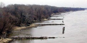
The Army Corps of Engineers installed these wing dams to force the current to the middle. The rushing water scours the bottom of the channel to keep navigation open. A new study alleges the wing dams slow the current during major floods and cause flood waters to be higher. Photo by Lester Graham.
A recent study concludes that some actions of the Army Corps of Engineers might be causing more, rather than less damage during major floods on rivers in the Midwest. The study by two Washington University professors found that wing dams, which jut out into the river, could cause big floods to rise even higher. The Great Lakes Radio Consortium’s Lester Graham takes a closer look at this study:
Transcript
A recent study concludes that some actions of the Army Corps of Engineers might be causing more, rather than less damage during major floods on rivers in the Midwest. The study by two Washington University professors found that wing dams which jut out into the river could cause big floods to rise even higher. The Great Lakes Radio Consortium’s Lester Graham takes a closer look at this study:
The Mississippi and the Missouri rivers are two of the major arteries for barge transportation in America. Millions of tons of grain, and raw materials are floated up and down the rivers each year. It’s the Army Corps of Engineers’ job to keep the rivers open to barge traffic. The Corps has been doing that job for the past 150 years. But since the 1930’s that effort has taken on immense proportions. Huge dams hold back the river, keeping the water high enough for the barges to travel up and down-stream. Big earthen dikes, called levees, wall in the rivers, keeping them from flooding farms and towns, but also keeping the water from reaching the natural flood plain. Robert Criss and Everett Shock studied flood levels and the effects of the Corps of Engineers projects. Criss says those dams and levees alone might be enough to disrupt the flow of the river and cause flood stages to be higher.
“But the other component is these structures called wing-dams which are jetties of rocks that project out perpendicularly into the channel. For high-flow conditions, these act something like scale in a pipe. They impede the flow, restricting the channel. That slows the velocity of the water down and that also makes the flood stages higher.”
The purpose of wing dams is to force the current to the middle of the river to scour out the navigation channel to keep it open for the barges. Researcher Everett Shock.
“So, they do the job they’re intended to do. It seems that there’s an unintended–perhaps unintended consequence of all these constructions along the river that shows up when we have a big flood and makes it to –on the basis of our study– makes these big floods worse.”
Criss and Shock say their study finds that since these flood control projects have been erected, there have been more big floods, such as the one in 1993 that flooded the Mississippi and some of its tributaries for most of the summer. Robert Criss.
“The fact is, before World War II, a flood stage of 38-feet is very rare and now it happens every five years.”
But not everyone agrees with the methodology used by the researchers. The
Corps of Engineers dismisses the researchers’ study, saying they used flawed data. Corps officials point to a study at the University of Missouri – Rolla. That study compared the 19th century method of measuring a river’s flow by timing how fast floats moved in the current to the methods used today. Dave Busse is a scientist with the Army Corps of Engineers. He says the original stream flow measurements –the ones Criss and Shock used— were inaccurate.
“The flows were over-estimated by 30-percent using this float measurements rather than the measurements than we use today.”
Criss and Shock are skeptical of new numbers that the Corps prefers. Saying it seems awfully convenient for the Corps because changing the numbers makes the historic floods look smaller and therefore makes the 1993 flood look unprecedented. Criss and Shock say based on the original records, there was as much water in past floods as in the 1993 flood but lower water levels. Criss and Shock say the difference between then and now is that the Corps’ big dams, levees, and wing dams constrict the river’s flow and make floods higher.
The Corps, however, has other criticisms of the Criss and Shock study. Dave Busse says the researchers ignored the role of the Corps’ reservoirs in the rivers’ watersheds. Busse says the reservoirs hold back water that would otherwise be part of a flood. And Busse says, another flaw is the researchers conclusions about wing dams. The Corps says the wing dams force water to deepen the channel and increases the flow of the river.
“So, what we have is the same –it’s a re-shaped river, but its carrying capacity is actually higher now. We can actually carry more water at the same stage. The river got deeper, therefore this conclusion that they’ve made is wrong.”
The Corps says there’s more to managing the river than the researchers have considered. Criss and Schock, meanwhile, say their study is not the first to be dismissed by the Corps of Engineers. They say other studies have found similar results, but the Corps dismissed them as well.
Environmentalists have been arguing for decades that levees and dams keep floodwaters from spreading out on their natural flood plains and cause higher flood levels. The Criss and Shock study adds to their arsenal of arguments to change the way the rivers are managed. But most environmentalists concede that we’ve become somewhat dependent on the Corps flood control projects. Chad Smith is with the environmental group,
American Rivers.
“In most ways both of these camps are right. The Corps is right that putting some of the structure in has helped to reduce the kind of annual flood events that always happen on a big river like this, but what they unfortunately have done is to exacerbate what happens when you have bigger floods and the wing dams and the levees and the dams themselves all are part of that.”
The Army Corps of Engineers says it’s reviewing its way of managing rivers in light of the 1993 flood. But they also note that while flood stages might be higher more often than they were in the 19th century, most of the time those floodwaters remain behind the floodwalls and levees, protecting the communities from high water, and the Corps says in the end, that’s the only fact that really matters.
The Army Corps of Engineers installed these wing dams to force the current to the middle. The rushing water scours the bottom of the channel to keep navigation open. A new study alleges the wing dams slow the current during major floods and cause flood waters to be higher. Photo by Lester Graham.
A recent study concludes that some of the flood control projects along the Midwest’s largest rivers might be making the severity of some floods worse. The Great Lakes Radio Consortium’s Lester Graham reports:
Transcript
A recent study concludes that some of the flood control projects along the Midwest’s largest rivers might be making the severity of some floods worse. The Great Lakes Radio Consortium’s Lester Graham reports:
The study, published in the journal Geology, looked at the history of flood stages and river flows along portions of the Mississippi and Missouri rivers. It concludes that the dams, dikes, and levees constrict rivers so that when there are massive floods, such as on the Mississippi in 1993, they make the situation worse. Everett Shock is a professor at Washington University and one of the authors of the study.
“There needs to be some very clever thought on how to go about some differences in management practices so that we aren’t making large floods worse.”
The Army Corps of Engineers, which built and maintains the flood control projects along rivers, says the study is flawed because it doesn’t use updated data and it doesn’t consider the role that man-made reservoirs play in holding backwater during floods. The Corps also notes that before the flood projects, the rivers often damaged homes, businesses and property on a large scale, something that the Corps says rarely happens now.