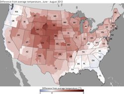
 The redder the area... the higher the difference from average temperature, June-August 2012. (Image courtesy of NOAA)
This is the Environment Report. I’m Rebecca Williams.
The experts are still finalizing the data, but it looks like 2012 will go on the books as the warmest year in the U.S. in recorded history (ever since 1895).
Jeff Andresen is a professor of geography at Michigan State University. He’s also the state climatologist, and he joins me now. So… 2012 looks like it’ll be the hottest year on record for the U.S. What about in Michigan?
“Michigan, we’re very close. We can say with certainty at this point that it’ll be at least in the top three, if we average over the state as a whole, and if the average for the month of December turns out to be more than 7 degrees Fahrenheit above normal, we would move into first place. But right now, based on preliminary data that we have, I think we’re probably going to fall just short and either be the second warmest or perhaps the third warmest, again it depends on what the final version says, but we’ll have missed the all-time record only by maybe a couple tenths of a degree, so it’s very, very close.”
RW: I think it’s useful to clarify what we mean when we talk about weather vs. climate. So weather is essentially what you see out your window…
Andresen: “Right. And it’s a very, very important distinction between the two. We are essentially looking at the same variables, whether that be temperature or wind speed or precipitation, but we’re looking over different periods of time, or with respect to time. Weather tends to be associated with relatively short term: minutes, seconds, days, perhaps. Climate, on the other hand, is looking at the same variables, but over extended periods of time: decades, sometimes centuries or more. So it’s a very subtle but important distinction to make.”
RW: One of the analogies I’ve heard is that climate change is loading the dice so there’s a higher probability that we’ll roll more extreme weather events. Looking into the future, what kinds of extreme events could we see more of in Michigan?
Andresen: “Well, the projections for the future, in general, all of them call for warmer temperatures in the future for our part of the world, without exception. They also suggest wetter… some of the projections say wetter, some actually say drier, but the majority say that we will have more precipitation in Michigan. The key or the caveat there is that the timing of it might be different. Increases in precipitation are thought to perhaps be concentrated during the cold season, in the winter; maybe in the spring, we’ll have some of that precip falling, maybe in liquid form. And that is a concern because the forecasts for summer precipitation are basically level. Some of them even call for less precip in summer and certainly for agriculture, for natural systems, that’s when our water needs are the greatest. Plants need water during the warm season, the growing season, and that is a red flag certainly as we look ahead.
But in terms of extreme events, there is some suggestion that we will certainly see more extreme high temperature events; also more extreme heavy precipitation events than we have in the past. And one that seems almost counterintuitive or doesn’t make sense: but at the same time we have more heavy precipitation events and that would be like a 24 hour total – we may also see more or higher frequency of drought at the same time. It’s referred to as intensification of the hydrologic cycle, so we just have more extremes, whether they be high or low.”
RW: Jeff Andresen is a professor of geography at Michigan State University. He’s also the state climatologist. Thank you so much!
Andresen: “My pleasure.”
That’s the Environment Report. I’m Rebecca Williams.