A city like Las Vegas is actually cooler than the desert, because of all the lawns and trees inside the city. And a city like Chicago is hotter than the tree-lined suburbs surrounding it.
(Photo courtesy of NASA)
Not all heat island effects are
the same. But, Rebecca Williams
reports, NASA scientists have
found there’s one thing all cities
can do to cool things down:
Transcript
Not all heat island effects are
the same. But, Rebecca Williams
reports, NASA scientists have
found there’s one thing all cities
can do to cool things down:
The NASA scientists found the heat island effect is much less intense in hot, dry parts of the country.
A city like Las Vegas is actually cooler than the desert, because of all the lawns and trees inside the city. And a city like Chicago is hotter than the tree-lined suburbs surrounding it.
It’s all about trees. Shady trees cool things down.
Lahouari Bounoua is one of the researchers.
“One of the most simple and natural ways of mitigating the excess heat is to plant trees within the cities.”
He says the key is to make sure the trees you plant are well adapted to the region, so you don’t end up wasting water. He says that’ll be even more important as the climate continues to change.
The rock, soil and tiny plants in a green roof help insulate a building.
That can cut heating and cooling costs. (Photo courtesy of the USDA)
Green roofs are a popular, but
expensive, way for building owners
to prove their green credentials.
Shawn Allee reports some
researchers feel they might do even
more environmental good than they
thought:
Transcript
Green roofs are a popular, but
expensive, way for building owners
to prove their green credentials.
Shawn Allee reports some
researchers feel they might do even
more environmental good than they
thought:
The rock, soil and tiny plants in a green roof help insulate a building.
That can cut heating and cooling costs.
Researchers at Michigan State University think they’ve found another
benefit, too.
Brad Rowe says the tiny plants absorb carbon from the air. Rowe says the
plants are small, so this carbon sequestration effect is small, too. But
he says green roofs are still better than plain-jane roofs.
“You have all these roofs everywhere and basically, they’re doing nothing
– they’re essentially dead. So, putting plants on them is one way to
sequester carbon above ground, in the leaves and stems, the roots, and even
in the soil that’s on top of the roof.”
Rowe says if Congress ever puts a price on carbon emissions, green roof
owners might get credit for sequestering carbon – and that could cut a
green roof’s high price tag.
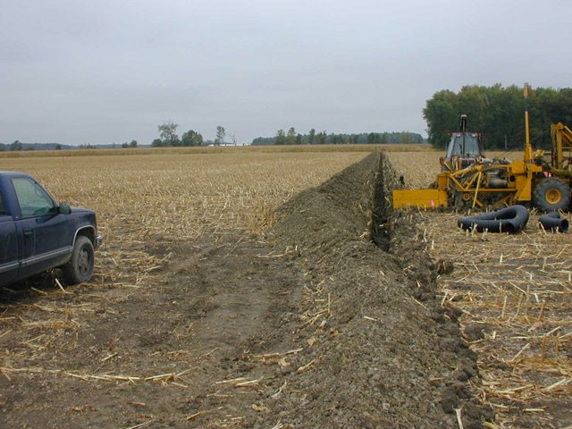
A newly dug drainage tile. These underground pipes keep the fields dry, but they're also a pathway for nitrogen fertilizers. (photo by Mark Brush)
Today, we begin a week-long series on pollution in the heartland.
Storm water runoff from farm fields contaminates the lakes that many cities use for drinking water. But rather than making farmers reduce the pollution, the government requires water utilities to clean it up and pass the cost on to their customers. In the first part of our series, the GLRC’s Lester Graham reports on efforts some communities have made to stop the pollution at the source:
Transcript
Today, we begin a week-long series on pollution in the heartland. Storm water runoff from farm
fields contaminates the lakes that many cities use for drinking water. But rather than making
farmers reduce the pollution, the government requires water utilities to clean it up and pass the
cost on to their customers. In the first part of our series, the GLRC’s Lester Graham reports on
efforts some communities have made to stop the pollution at the source:
To a great extent, nitrogen fertilizer determines how big a corn crop will be. But often, farmers
use more nitrogen than they really need. It’s a bit of a wager. If conditions are just right, that
extra nitrogen can sometimes pay off in more bushels of corn. But just as often the extra nitrogen
ends up being washed away by rain.
That nitrogen can get into lakes that are used for public drinking supplies. If nitrate levels get too
high the nitrogen can displace oxygen in the blood of children under six months old. It’s called
‘blue baby syndrome.’ In extreme cases it can cause death.
Keith Alexander is the Director of Water Management for the city of Decatur, Illinois. He recalls
that the Illinois Environmental Protection Agency required his city to give families with babies
bottled water because nitrogen levels exceeded the federal limits.
“For approximately six years, while we went through the motions of determining what was best
for our community, we did issue bottled water on an infrequent basis when the nitrate levels did
indeed elevate.”
The City of Decatur had to get nitrate levels down. So, they piggy-backed on federal and state
incentives offered to farmers to use better management practices. The city gave farmers money
to build terraces to reduce soil erosion. It gave money on top of federal and state tax dollars to
farmers to put in grass waterways to slow water rushing off the fields. The city gave farmers
money on top of federal and state incentives to use conservation tillage methods. They offered to
pay to install artificial wetlands so plants would take up the nitrogen before it got into the public
water supplies. It gave farmers money to use a chemical that help stabilize nitrogen in the soil.
With all that city and state and federal money offered to farmers, was it enough to reduce nitrogen
to safe levels?
“Unfortunately, no.”
Keith Alexander says some farmers did take advantage of the incentives. But not enough of
them.
“We’ve done quite a bit on a voluntary basis with a lot of great cooperation from the agricultural
community, but in spite of all that, we would still at times have elevated nitrate levels in Lake
Decatur.”
The city had to build the largest nitrate reduction facility in North America, at a cost of 7.5 million dollars to ensure its drinking water did not exceed the federal standards for
nitrates.
The people who tried to persuade farmers to sign up for the nitrogen reduction programs say
many of the farmers were skeptical that they were the cause of the problem. Some didn’t care.
And some were just skeptical of government programs and the red tape involved.
Steven John is the Executive Director of the Agricultural Watershed Institute. He’s still working
with farmers to reduce nitrogen runoff in the region. Today, the reason is not Decatur’s lake but a problem farther downstream.
“To a fairly large extent, the driver for addressing nitrogen issues now is loading to the Gulf of
Mexico. And, in one sense, because we’ve been at this for some time here and developed a little
bit of a history of city-farm cooperation– also developed good monitoring data, you know, to be
able to look at trends over time– we’re in good position to use our watershed as something of a
laboratory to test ideas that might be applied elsewhere in the corn belt.”
Nitrogen from the Decatur lake watershed eventually flows into the Mississippi River. Illinois,
just like all or parts of 37 other states drain into the Mississippi and finally to the Gulf of Mexico.
There researchers believe the nitrogen fertilizes algae growth, so much so that when the algae
dies and sinks to the bottom of the gulf, the decomposing vegetation robs the water of oxygen
and causes a dead zone that can be as large as the state of New Jersey some years.
But getting farmers to change their farming practices when it was causing problems for the city
next to them was difficult. Getting them to change for a problem hundreds of miles away is even
tougher.
Ted Shambaugh is a farmer who has changed. He says the reasons farmers don’t take the
nitrogen problem more seriously is complicated, but as far as he’s concerned, it’s part of how
farming has changed in the last few decades:
“This is going to fly against a lot of common thought, I suppose, about the farmer, and it does get
me in trouble sometimes, but the farmer has become inherently lazy in his management
techniques. They’ve even gone to the fact that even though they’ve got a 150,000 or 200,000
dollar tractor sitting there, they hire their nitrogen put on. Why do they do that? Well, a lot of it
is because they then have somebody to blame. That, if it didn’t go on right, ‘Well, I didn’t do
that.’ Well, we kind of think that’s what we get paid for, is management.”
Most people in cities like Decatur won’t say things like that about the farmers in the countryside
about them. The economic well-being of many of the cities in the corn belt are highly dependent
on agriculture. Criticizing farmers is just not done, even when many of those farmers won’t lift
a finger to clean up the water that their city neighbors have to drink.
Developers are feeling encouraged by last month’s US Supreme
Court ruling on wetlands. The High Court was deciding on which wetlands deserve protection under the Clean Water Act. Some say it’s more likely
they’ll get their building permits now. Defenders of the Clean Water Act
think those high hopes are premature. The GLRC’s Tracy Samilton takes
us to the wetland where the fight began:
Transcript
Developers are feeling encouraged by last month’s U.S. Supreme Court
ruling on which wetlands deserve protection from development under the
Clean Water Act. Some say it’s more likely they’ll get their building
permits now. Defenders of the Clean Water Act think those high hopes are
premature. The GLRC’s Tracy Samilton takes us to the wetland where the
fight began.
Wetlands are supposed to be wet, right? Certainly wetter than this mucky little forest in
a township in Southeast Michigan, surrounded by subdivisions and strip malls. Tim Stoepker
leads the way through battalions of attacking mosquitoes. He points at a big puddle:
“Basically, you have a forested wetland here, with no diversity of plant life because you have
such a thick canopy of trees and you don’t typically have all your wetland,
typical wetland plants on the interior here because of that and because there’s no standing
water, you don’t have any of your aquatic species.”
Stoepker’s business suit trousers are getting streaked with mud but he keeps going. Next stop
is a drainage ditch at the edge of the property. It’s pretty dry:
“Now, if we were to come out here in August or July, I mean, that ditch would even be, there
would be nothing in that ditch.”
Stoepker has represented landowner Keith Carabell since the mid-1980s. Carabell was denied a permit
to build senior condos on his property. He appealed it all the way to the U.S. Supreme Court.
Stoker thinks if the nine Supreme Court Justices had seen this ditch in person, last month’s
wetlands decision would have been different. A majority would have ruled that the test for
Clean Water Act protection is permanent surface water flowing into a navigable water. Even so,
he’s optimistic. Five Justices reaffirmed that the Clean Water Act pertains only to wetlands
with a “significant nexus,” or connection, to navigable waters. He says that’s not the case
here:
“It’s hydrologically isolated from receiving and sending waters.”
But the U.S. Army Corps of Engineers sees it differently. The Corps is the agency that decides
if a wetland falls under the Clean Water Act. If so, it then issues or denies building permits.
The Corps told field officers not to talk to reporters about this or any case pending guidance
from headquarters. But a source familiar with Corps regulations says water from this wetland
does flow into the ditch. From there, it empties into a drain, which dumps into a stream and
then leads to Lake St. Clair a mile away, one of the most polluted bodies of water in the Great
Lakes region. The source says the wetland also connects to the drain on another side of the
property, and it will meet the significant nexus test when the case goes back to the lower
court.
Environmentalists like Jim Murphy of the National Wildlife Federation hope that’s true.
Murphy says small wetlands like this one need to be protected, despite their lack of surface
water and showy aquatic species:
“I think we make a mistake when we just feel that the only thing we need to protect are
charismatic wetlands, for a number of reasons. For one, even wetlands that don’t necessarily look that pretty
that pretty are oftentimes performing enormous functions, whether it be habitat, flood control,
water filtration….”
All functions that Army Corps of Engineers mentioned when it denied a permit in this case.
Murphy says the looming question now is, how will the agency react to the ruling? If they pull
back, he thinks we will lose wetlands at a much quicker pace. Or the Corps could interpret
the ruling as broadly as possible:
“We feel that if the Corps is willing to stand firm and be aggressive, that they can still
maintain protection for a good number of waters.”
Murphy thinks even at best, the Supreme Court ruling will encourage even more developers like
Keith Carabell to challenge permit denials in court. That may be true, but Tom Stoepker, the
attorney for Keith Caraball, says all that most developers want are more thoughtful decisions
from the Corps, and they want the Corps to back off from places it ought not to be. He says
that includes this wetland where anyone can see the water in it isn’t going anywhere.
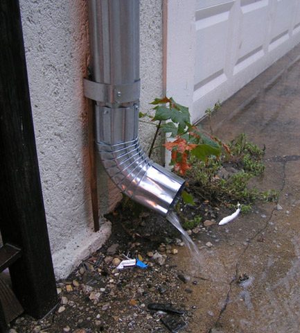
Everybody's got a gutter... and they're part of the urban runoff problem. Rain picks up dirty soot and other chemicals from roofs and heads into the gutter. During storms, the dirty water rushes down the gutters and down streets into storm drains... and can pollute beaches, drinking water and wildlife habitat. (Photo by Shawn Allee)
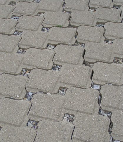
The pervious pavement at the Chicago Center for Green Technology lets water seep into the ground instead of heading into the sewer drain. (Photo by Shawn Allee)
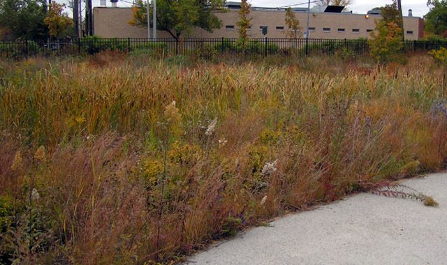
The rain swale near the parking lot at the Chicago Center for Green Technology is full of native plants that absorb water that would otherwise head into the storm water system. (Photo by Shawn Allee)
One of the ten threats to the Great Lakes identified by experts across the region is nonpoint
source runoff. It’s a catchall category for pollution that’s not being spewed from one identifiable
source. The federal government’s finding that rain washing off concrete and asphalt in cities and
suburbs poses as big a threat to the Great Lakes as waste coming out of a factory pipe. Shawn
Allee has a look at the government’s effort to cut water pollution by remaking the urban
landscape:
Transcript
We’re continuing our series on Ten Threats to the Great Lakes. The Great Lakes Radio
Consortium’s Lester Graham is our guide through the series. Today a look at a broad problem
with no simple solution:
One of the ten threats to the Great Lakes identified by experts across the region is nonpoint
source runoff. It’s a catchall category for pollution that’s not being spewed from one identifiable
source. The federal government’s finding that rain washing off concrete and asphalt in cities and
suburbs poses as big a threat to the Great Lakes as waste coming out of a factory pipe. Shawn
Allee has a look at the government’s effort to cut water pollution by remaking the urban
landscape:
(rain running into a sewer)
Water from a rain gutter is pouring into a nearby storm sewer drain. That protects property from
water damage and flooding. But at the same time, they pose an environmental problem for the
Great Lakes.
Roofs, streets and parking lots are made of hard materials like concrete or asphalt. During
storms, rain rushes off these surfaces into storm drains.
The problem is this: the runoff isn’t pure.
Brian Bell’s a storm water expert with the Environmental Protection Agency. He says rain picks
up pollutants on all those roofs and streets, things such as:
“Antifreeze from cars, motor oil, brake fluid, copper from the brake pads, cigarette butts from
trash, household hazardous waste, pesticides that may be overapplied.”
And for most sewer systems, that’s not the worst of it.
“The problem with storm water is, once its mobilized and goes into a storm sewer system, that
system does not treat the waste, so all of those things go to the local waterway untreated.”
In this region, runoff flows into the Great Lakes, where it pollutes beaches, drinking water, and
wildlife habitat.
To fight this, the EPA’s trying something new. It wants to make hard, urban landscapes softer.
The idea’s to replace concrete and asphalt with more soil and plants. That way, water can sink
into the ground and stay out of storm drains.
But how do you do that?
Well, the EPA’s working with places like the Chicago Center for Green Technology to show people
how. The city hopes residents and developers will use what they see here in their own projects.
(city sounds in)
Grace Troccolo’s guiding a tour of the facility.
First stop?
“Our parking lot is slightly pitched, so all of our rainwater flows off into these vegetated bioswales,
which when I’m not with people in the business, I call ‘ditch with plants.'”
The plants aren’t typical bushes or flowers. They’re mostly tall, prairie grasses native to the
Midwest. Their roots help water seep deep into the ground. The Center has several bio-swales,
and they all keep runoff on site and in the ground.
Another stop on the tour is a 40-foot section of the building’s roof. It’s covered with a matt of
short, tangled creeping plants. Grace explains why they’re here.
“So here we are at our green roof. Again, getting back to our issue of storm water management,
the city would like to see more vegetated surfaces and of course, in the city like Chicago there are
a lot of roof surfaces and so this section of the roof is designed to hold all of the rainwater that
falls on it during a one-inch storm.”
Again, the roof’s vegetation retains water and keeps it out of storm drains. Because of these
technologies, the building is an urban runoff success story.
All told, the Center releases less than half as much water to storm drains as similar buildings do.
The EPA wants the average home or business owner to follow suit, but price might keep that from
happening. Green roofs, for example, are more expensive than conventional ones.
But some observers say the biggest obstacles in fighting urban runoff are political. Stephen
Bocking teaches environmental policy at Trent University. He says the public’s used to pointing
fingers at a handful of big, industrial polluters.
People just aren’t used to seeing every house and business as a source of pollution.
“It’s much more difficult to deal with the problem when you’re talking about millions of separate
sources. People can’t just say well, it’s the job of industry or the job of the government to deal with
it. It’s the job of everyone to deal with it in some way.”
In other words, we’re all to blame.
Every new building in a city, or home in a subdivision, creates more hard surfaces, such as new
driveways, new parking lots and new roofs.
“It’s pretty hard to deal with a form of development which is intrinsic to our way of life. It involves
thinking about how we live our lives and how design and build our cities.”
Bocking says the EPA’s plan might not be enough to make up for all the roads and other hard
surfaces we’re building. He says, to succeed, we’ll need to change how we develop land.
There’s not much political support to stop that kind of development right now, so for the time
being, hard surfaces will continue to win out.
The Karner blue butterfly is an endangered species. (Photo courtesy of U.S. Fish and Wildlife Service)
There are several groups in the region working to protect and restore the endangered Karner blue butterfly. Now these efforts could be helped by a new computer mapping and statistical modeling technique. The Great Lakes Radio Consortium’s Chuck Quirmbach has more:
Transcript
There are several groups in the region working to protect and restore the
endangered Karner blue butterfly. Now these efforts could be helped by a
new computer mapping and statistical modeling technique. The Great Lakes
Radio Consortium’s Chuck Quirmbach has more:
Habitat maps for endangered species can be based on broad general
estimates. But some scientists hope a combination of computer
software and data such as soil type and vegetation will lead to
more accurate information on where the Karner Blue butterfly lives.
David Mladenoff is a professor of Forest Ecology at the University of
Wisconsin – Madison. He says having a better idea of the butterfly’s
habitat might save companies money on things like surveying costs.
“In other words, if they say we’re planning on doing work on this utility
right away or potentially harvest this area of forest, is this even
a place we have to be concerned about for the Karner Blue butterfly
occuring?”
The U.S. Fish and Wildlife Service, a state agency, and some power
companies are funding a computer mapping project in Wisconsin.
Scientists say the same technique could be used in other states.
Dysart Woods in southeast Ohio is an old-growth forest. Many of the trees are more than 300 years old. (Photo courtesy of dysartwoods.org)
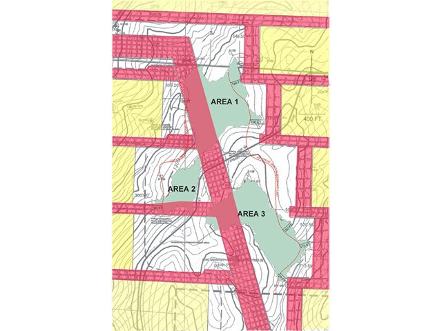
Ohio Valley Coal Company's mine operations map. Green = Dysart Woods Old-growth forest. Yellow = longwall mining panels. Red = Room and pillar mining. (Image courtesy of Buckeye Forest Council)
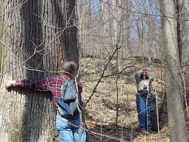
Ohio University professor and hike leader Phil Cantino provides some perspective on this massive oak.
The need for cheap energy is coming into conflict
with efforts to preserve a forest. Coal mining companies are using a technique that causes the land to subside and sometimes changes natural underground water systems. Environmentalists say mining underneath a forest preserve could destroy the ecosystem. The Great Lakes Radio Consortium’s Lisa Ann Pinkerton reports on environmental activists who are defending the
forest:
Transcript
The need for cheap energy is coming into conflict with efforts to preserve a forest.
Coal mining companies are using a technique that causes the land to subside and sometimes
change natural underground water systems. Environmentalists say mining underneath a forest
preserve could destroy the ecosystem. The Great Lakes Radio Consortium’s Lisa Ann Pinkerton
reports on environmental activists who are defending the forest:
For decades, the coal mining industry has been using a technique of extraction called
long wall mining. Industry officials say it’s the most effective way to get the bituminous
coal out of the ground. In traditional room and pillar mining, the land above is not disturbed.
But the long wall machine leaves no support for the 1000-foot tunnel created in its wake. After
the coal is extracted, the ground caves in, causing the land to sink.
Dysart Woods, in southeastern Ohio, is slated for such a fate. The conservation group,
Buckeye Forest Council, wants to block the woods from mining. Its members believe long
wall mining will destroy the old-growth forest. The four hundred and fifty acres, fifty-five
acres of the trees are more than 300 years old. Fred Gittis is an attorney who has volunteered
his services to protect the woods.
“And these woods are precious, and they are among the last old-growth forest areas remaining,
not only in Ohio, but in this part of the country. Recently a documentary was filmed in Dysart Woods, because it has some of the conditions that would have existed at the time of George
Washington’s life.”
Gittis argues state should repeal the mining permit granted for Dysart Woods. Ohio Valley
Coal was granted the permit in 2001. As steward of the woods, Ohio University disputed the
permit for three years. But last November, it agreed to drop its appeal, in exchange for $10,000 from the state to study the forest’s water, as it is undermined. Ohio Valley
Coal Company would drill the wells needed. But the Buckeye Forest Council says a study doesn’t
solve the problem.
“First of all it is just a water monitoring project. It offers no protection to the woods.
Second of all, they don’t have the base line data right now to compare to what it normal.”
That’s Susan Heikler, Executive Director of the Buckeye Forest Council. When Ohio University
accepted the mining permit, her organization took up the fight. The group worked with lawyer
Fred Gittis and nationally known experts to review the science of the Coal Company’s mining
plan. Gittis says the Council’s experts were not impressed.
And, both hydrogeologists and mining experts have indicated that the basic science related
to this mining permit is, not to be insulting but, junk.”
The plan calls for long wall mining within 300 feet of the old-growth forest. However,
experts from the Buckeye Forest Council say a 1500 foot buffer around the woods
is the only way to insure the protection of the hydrology – the natural water system that
sustains the forest.
In a major concession two years ago, the Coal Company agreed not to long wall mine directly
under Dysart Woods. Instead, room and pillar mining is planned. The Company says that will
delay subsidence for centuries to come. Attorney Fred Gittis says without core samples from
directly under the woods, the company doesn’t have the data to back up this claim.
“If you don’t know what that rock is, if it’s soft like claystone or shale, it can collapse.
And so its pretty basic stuff.”
Attorneys for the company declined to be interviewed for this story. In statements, the
Company defends its lack of data by pointing to exemptions they were granted by the Department
of Mineral Resources. The Company stands by its assertion that, quote, “trees and other surface
vegetation will absolutely not be affected by mining.” But in September, the story changed. In
court, a mining consultant for the company, Hanjie Chen, testified that the forest floor would
sink 5 inches. Attorneys for Ohio Valley Coal abruptly stopped his testimony after this
statement. But Gittis says the damage to the coal company’s case is already done.
Although Buckeye Forest Council rested its case in July, the defendant, Ohio Valley Coal is
still adding witnesses and dragging out the case. Fred Gittis says the Company is trying to
exhaust the Buckeye Forest Council’s legal funding. He adds that this is why he volunteers his
expertise.
For the time being, mining under the old growth forest has been pushed back until the hearings
conclude in November.
For the Great Lakes Radio Consortium, this is Lisa Ann Pinkerton.
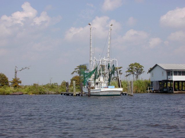
Small shrimp fishers are concerned about the Gulf of Mexico 'dead zone' because shrimp can't survive in the oxygen depleted water. (Photo by Lester Graham)
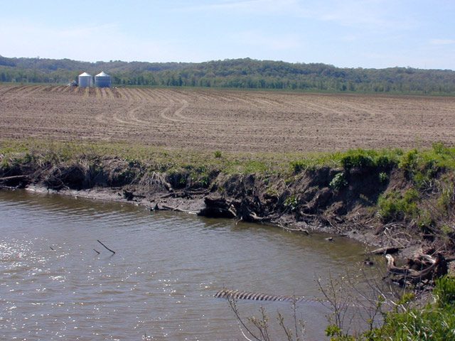
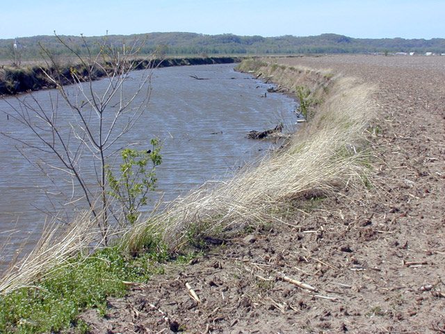
Some Midwest farmers leave no grass buffer between their fields and nearby streams, allowing excess nitrogen to easily enter the waterways. (Photo by Lester Graham)
Some farm fields drain stormwater from treated farm fields directly into nearby creeks that are tributaries of the Mississippi River. Scientists believe the fertilizer pollution contributes to the Gulf 'dead zone.' (Photo by Lester Graham)
The government has been working with agriculture, environmentalists and scientists to come up with a way to reduce the size of a ‘dead zone’ in the Gulf of Mexico. The dead zone causes problems for the fisheries in the Gulf. It’s believed the dead zone is caused by excess nitrogen on farm fields in the Midwest that’s washed to the Mississippi River and then to the Gulf. A government task force has determined that if the flow of nitrogen into the Gulf can be cut by 30 percent, the size of the dead zone can be reduced. The Great Lakes Radio Consortium’s Lester Graham reports… a new study predicts a 30 percent reduction won’t be enough to make a difference:
Transcript
The government has been working with agriculture, environmentalists and scientists to
come up with a way to reduce the size of a ‘dead zone’ in the Gulf of Mexico. The dead
zone causes problems for the fisheries in the Gulf. It’s believed the dead zone is caused
by excess nitrogen on farm fields in the Midwest that’s washed to the Mississippi River
and then to the Gulf. A government task force has determined that if the flow of nitrogen
into the Gulf can be cut by 30 percent, the size of the dead zone can be reduced. The
Great Lakes Radio Consortium’s Lester Graham reports… a new study predicts a 30
percent reduction won’t be enough to make a difference:
The idea that fertilizer used on a corn field in the Midwest can cause a ‘dead zone’ in the Gulf of Mexico
is hard to fathom. But when you realize that all or parts of 31 farm states drain into the
Mississippi basin, it becomes a little easier to understand. Excess nitrogen causes a huge algae
bloom in the Gulf. When the vegetation dies, it decays on the bottom and bacteria feed
on it. The huge expanse of bacteria depletes the oxygen.
Nancy Rabalais is a professor with the Louisiana Universities Marine Consortium. She
says most life under the water needs that oxygen to survive.
“The oxygen is depleted in the water column so that the fish and shrimp, anything that
can swim, leaves the area. All the indicators show that it’s gotten much worse since the
1950’s to present, and that’s consistent with the increase in nitrogen in the Mississippi
River.”
Since 1985, Rabalais has been measuring the size of the dead zone every year. The zone
ranges in size from about 2,000 square miles to about 10,000 square miles.
That’s about the size of Lake Erie.
Jerald Horst is a biologist with the Louisiana Sea Grant. He says it’s hard to know the
exact impact on life under the sea…
“Very difficult to say ‘Gee, this year the shrimp
production is down somewhat because of hypoxia,’ or whether the shrimp production is
down somewhat because of a host of other environmental factors.”
But the fear is the hypoxic zone could stop being a dead zone that shrinks and grows
– and one year disappeared altogether… and instead become a permanent dead zone where nothing would ever live. That’s happened in a few other places on the globe such
as the Black Sea. It’s not clear that the same kind of thing can happen in the Gulf, but
signs are ominous. Horst says upwellings of oxygen-starved water near the shore after a
storm used to be very, very rare. Lately, they’ve become more and more frequent. He
says it means the problem is getting worse.
There’s still a lot of debate about whether the dead zone in the Gulf is a serious problem.
But, at this point, most agricultural agencies and farm groups have stopped disputing the
science and whether their nitrogen is causing the problem. Now they’re trying to figure
out the best and cheapest way to deal with it.
The government task force that’s working on the problem has arrived at an Action Plan;
the task force has determined the amount of nitrogen getting into the Mississippi River
needs to be cut by 30 percent to reduce the Gulf zone by half in ten years.
Donald Scavia has been working on the problem. He was involved in the debate when he
was a senior scientist with the National Oceanic and Atmospheric Administration. He’s
retired from NOAA and now directs the Michigan Sea Grant. From his office at the
University of Michigan, Scavia explained how the task force arrived at the figure.
“We agreed to a 30 percent reduction because it was similar to what was done in other
places, probably acceptable to the community and will head us in the right direction.”
After arriving in Michigan, Scavia started research to determine if a 30 percent reduction
would do the job. Using three very different computer models, Scavia and his team
learned that they could actually predict the size of the dead zone from year to year…
“From that analysis, that not only looked at the size of the zone, but actually looked at
potential inter-annual variability caused by changes in climate, changes in weather say
that probably 35 to 45 percent nitrogen load reduction’s going to be needed to get to that
goal in most years.”
Scavia’s study was published in the journal Estuaries.
A 35 to 45 percent reduction is a much tougher goal than the 30 percent the task force is
recommending. As it is, states were planning massive artificial wetlands and extensive
drainage programs to soak up excess nitrogen before it got to the tributaries that fed the
Mississippi River. They also planned to get farmers to reduce the amount of nitrogen
they’re using. That’s a tough sell for a couple of reasons. First of all, it would have to be
voluntary because nitrogen use is nearly completely unregulated. Second, farmers
often use what they call an insurance application of nitrogen… they use a little more than
is actually needed to get a good crop, because nitrogen is relatively cheap. The excess
often ends up washed into ditches and streams and creeks and rivers… and finally to the
Mississippi and the Gulf of Mexico’s dead zone. So… cutting nitrogen flow into the
Mississippi by 30 percent was a huge task. Cutting nitrogen by as much as 45 percent… well… you can imagine…
For the Great Lakes Radio Consortium, this is Lester Graham.
Small shrimp fishers are concerned about the Gulf of Mexico 'dead zone' because shrimp can't survive in the oxygen depleted water. (Photo by Lester Graham)
Some Midwest farmers leave no grass buffer between their fields and nearby streams, allowing excess nitrogen to easily enter the waterways. (Photo by Lester Graham)
Some farm fields drain stormwater from treated farm fields directly into nearby creeks that are tributaries of the Mississippi River. Scientists believe the fertilizer pollution contributes to the Gulf 'dead zone.' (Photo by Lester Graham)
A new study predicts the government’s plan to reduce the size of the ‘Dead Zone’ in the Gulf of Mexico won’t be strong enough to make a difference. The Great Lakes Radio Consortium’s Lester Graham reports:
Transcript
A new study predicts the government’s plan to reduce the size of the “Dead Zone” in the Gulf of
Mexico won’t be strong enough to make a difference. The Great Lakes Radio Consortium’s
Lester Graham reports:
The Dead Zone in the Gulf is believed to be caused by excess nitrogen used by farmers in the 31
states that drain into the Mississippi and ultimately into the Gulf of Mexico. The Dead Zone
causes problems for the fisheries in the Gulf. A study published in the scientific journal, Estuaries, predicts that an Action Plan put together by a government task force might not
go far enough. Michigan SeaGrant director Donald Scavia used computer modeling in the
study…
“What we tried to do here is take three different, very different models and ask the same question
of those models to try to get an answer.”
The answer was the same… the government task force plan to reduce the amount of nitrogen
reaching the Mississippi River by 30 percent is not enough. The models indicated a 35 to 45
percent reduction is needed to shrink the Dead Zone by half in the next ten years.
For the Great Lakes Radio Consortium, this is Lester Graham.
According to a new study, property next to a clear lake is worth more than property next to a murkier lake. The Great Lakes Radio Consortium’s Christina Shockley has more:
Transcript
According to a new study, property next to a clear lake is worth
more than property next to a murkier lake. The Great Lakes Radio Consortium’s Christina Shockley
reports:
Researchers from Bemidji State University looked at 37 lakes in upper
Minnesota. They collected sale prices on homes, and compared them to
pre-existing water clarity levels. Patrick Welle is a professor of
Economics and Environmental Studies at Bemidji State. He co-authored the
study.
“So we ran the model not only over the twelve hundred and five sales, but
we also ran it by the six different regions separately, and in each case water
quality is one of the most significant predictors of the sale price of the lakeshore
property.”
So, the clearer the lake water, the higher the property value. Researchers say
landscaping, clearing vegetation up to the shore, and fertilizing can decrease
water clarity. They say a manicured lawn can boost property value right away,
but in the long run, it could be a detriment.
For the Great Lakes Radio Consortium, I’m Christina Shockley.
 A city like Las Vegas is actually cooler than the desert, because of all the lawns and trees inside the city. And a city like Chicago is hotter than the tree-lined suburbs surrounding it. (Photo courtesy of NASA)