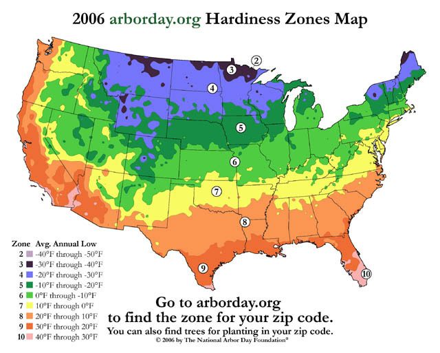
 The National Arbor Day Foundation's revised hardiness zone map. (Photo courtesy of the National Arbor Day Foundation)
If you’ve been thinking about landscaping your yard, you should know things have
changed. The climate is warming so quickly that one organization has changed the
plant hardiness zone map. That’s the little map you sometimes see on the back of
seed packets. Lester Graham reports… you might want to check out the new map
before you spend hundreds of dollars on a tree that might not live long in your
warmer zone:
Transcript
If you’ve been thinking about landscaping your yard, you should know things have
changed. The climate is warming so quickly that one organization has changed the
plant hardiness zone map. That’s the little map you sometimes see on the back of
seed packets. Lester Graham reports… you might want to check out the new map
before you spend hundreds of dollars on a tree that might not live long in your
warmer zone:
You know, I’ve talked to a lot of gardeners and homeowners who do their own
landscaping about this plant hardiness zone map change, and at first they’re
kind of astounded. The growing zones are changing? Because it’s getting warmer?
But then, they sort of pause and think for a moment… and usually say something like,
“That makes sense.”
The United States Department of Agriculture issues the plant hardiness zone map.
It’s basically a map of the annual average low temperatures that helps folks figure
out what they can plant and expect to survive. But the USDA hasn’t updated its map
since 1990.
The spokesman at the National Arbor Day Foundation, Woody Nelson – I kid you not,
the Arbor Day guy’s name is Woody – Woody says his organization issued a new
map because it really needed to be updated:
“You know, people were asking us to help out, you know, ‘This old USDA map just doesn’t
seem to work for us anymore. I don’t think it’s accurate. What can you do to help?’
So we took it upon ourselves to give tree-planters the most up-to-date information
that we could.”
So the National Arbor Day Foundation looked at the low temperature data gathered
by the National Oceanic and Atmospheric Administration since 1990, and the people
were right: things are warming up:
“And over that 15-year span that we used, much of the country had warmed a full
hardiness zone.”
And there’s a ten degree difference from one zone to the next. It shows a real on-
the-ground trend.
Richard Andres is with Tantre Farm. They grow organic produce for farmers’
markets like this one in Michigan. Andres didn’t know about the new Arbor Day
Hardiness Zone map, but it makes sense to him. He says he’s seeing more
extremes:
“You know, last winter was unusually warm. The winter before, unusually warm.
So, we really didn’t even get a decent freeze. We had a huge amount of bugs the
following spring. So we are noticing more extremes.”
But a farmer or gardener can adjust things for annual plants. Long term, you’re
probably wondering whether you can now plant that dogwood or whether you
should plant that spruce from up north.
(Sound of sprinkler)
Phil Walsh sells a lot of trees at Lodi Farms nursery. He knew about the new Arbor
Day Hardiness Zone map. But, he says there’s a lot more to think about than just
the annual average low temperature when you’re thinking about planting:
“Cold is not the only, or really the most, important factor when determining plant
hardiness. Questions like soil: is it well-drained; is it not; is it wet; is it dry; is it acid
or is it alkaline; do you have wind; do you have shade? Questions like this: is it high
in organic material or low in organic material? These tend to have more impact on
whether or not plants survive than strictly the zone rating.”
Walsh says the trees are pretty tough, and most of them can adapt:
“Yes, things have warmed up over the last 15 years and they may well continue or it may change and it may go down. Pick a good, hardy plant that’s well-suited for your soil
and typically one that’s native here, that’s gone through these temperature changes
in the past and I don’t expect anybody’s going to have any problems with them.”
That’s not to say that every kind of tree is taking this in stride. For example, black
spruce trees adapted to Canadian and upper New England cold might not be such a
good choice as far south as it’s been grown in the past.
Woody Nelson at the National Arbor Day Foundation says trees native to the North
are starting to be affected by the warming climate:
“There’s a whole lot of white pines that have been planted in Georgia, in the South
as a nice landscape tree over the years. And now those white pines are coming
under a little bit of stress. The native lodge pole pines, the native loblolly pines in the
deep South, again native species are something that we want to promote and stick
with.”
So, the basic rule is: if the plant hardiness zone map has shifted one growing zone
warmer in just 15 years, you’ll probably want to stick to trees native to your area, or
from just a little south of you just in case this warming trend sticks around for a while.
For the Environment Report, this is Lester Graham.