Drilling for Oil and Gas Near the Great Lakes

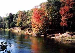
  • The AuSable River in Michigan is a popular destination for trout anglers. (Photo courtesy of Erin Hull)

A popular trout stream is the focus of a new battle over oil and gas development in the Great Lakes region. An energy company wants to drill for oil and gas under a publicly-owned natural area. The ensuing controversy is a complex round in an old debate over protection of wildlife habitat versus development of valuable mineral rights. The Great Lakes Radio Consortium’s Sally Eisele reports:

Transcript

A popular trout stream is the focus of a new battle over oil and gas development in the Great
Lakes region. An energy company wants to drill for oil and gas under a publicly-owned natural
area. The ensuing controversy is a complex round in an old debate over protection of wildlife
habitat versus development of valuable mineral rights. The Great Lakes Radio Consortium’s
Sally Eisele reports:


The Mason Tract is one of the last semi-wilderness areas in Michigan’s lower peninsula. The
hilly, forested acres by the south branch of the Au Sable River are the historical playground of
Henry Ford, George Mason, and other early auto executives, who made the difficult journey
North to fish for the stream’s elusive trout. The land belonged to Mason and he bequeathed it to
the state when he died in 1955 with the condition that it remain undeveloped.


(sound of stream)


On this rainy autumn day, the land looks much as it did then. The river winds its way through 14
miles of red pine, aspen and birch. And the brown trout that lurk in the shadows of the stream are
still legendary.


“People come from all over the world to fish and recreate along this river system.”


Rusty Gates owns a small fishing lodge nearby and is founder and president of a group called
Anglers of the Au Sable. He has lived by the river most of his life.


“The Mason tract. You go over to the trails and they are the way they’ve been for the last 50
years. You’re just as likely to see deer, turkey bear. This is just one of the best special spots left
in northern lower Michigan and it’s worth preserving.”


Gates leads the way up a well-worn trail from the river here to a small open air chapel—a slate-
roofed sanctuary, basically—built in memory of George Mason. But just over the rise, the land is
part of the Huron National forest. It’s on that federal land that the Savoy Energy Company of
Traverse City wants to drill a two-mile deep slant well to access the mineral deposits it has leased
under the state-owned Mason Tract. Rusty Gates learned about the plan on June 10th.


“On the 15th , I sent out an email letting people see this notice. And within 20 minutes I had a
response back from Seattle, San Francisco, Atlanta and Vermont. People offering to help.”


The drilling proposal has drawn heavy opposition from environmentalists, sports enthusiasts and
some lawmakers who raise a host of concerns. If the well is drilled, a road will be built, trees will
be cut down and, at least initially, a well will be pumping oil or natural gas not far from the
chapel 24 hours a day. Opponents are worried about noise, possible spills and noxious odors.
They complain that the effect of any drilling will be to destroy the character of this unique tract of
land. Savoy Energy has refused repeated requests for interviews. The state Department of
Environmental Quality has twice rejected Savoy’s application for a drilling permit, asking the
company to consider other sites for the wellhead itself. But DEQ spokesman Hal Fitch says
legally, Savoy is on solid ground.


“The leases give the company the right to go in and explore for and develop and produce oil and
natural gas. We need to take into account the citizens concerns there. But we need to do it in a
way that honors those concerns as well as the property rights of Savoy Energy.”


Property rights are at the heart of this dispute. In a situation that goes back to the early settlement
of the country, land and the mineral rights are often owned separately. In Michigan, the mineral
rights dominate, and sometimes state, federal and private interests collide. A similar conflict over
proposed drilling along the Lake Michigan dunes ten years ago cost the state 90 million dollars to
settle. David Dempsey of the Michigan Environmental Council says the Mason Tract fight could
also be costly if a compromise isn’t reached.


“I think it’s part of a much bigger issue that’s going to continue until we live up to our
responsibilities as a people and as a government. The issue is, are there some areas that are
publicly owned either the surface or the subsurface that are so sensitive they should never be
developed?”


The Mason Tract issue has renewed calls for laws better protecting sensitive watersheds. But
University of Michigan geologist Steven Kesler cautions, there is no way to eliminate risk in oil
and gas exploration.


There’s no way you could drill a well and assure yourself there would not be an accident.
I think it would be fair to say the risks are small, but the risks are there.”


Kesler notes that with more than 11-thousand oil and gas wells currently in operation, Michigan’s
track record is good. And with increased demand for domestic fuel sources, he says conflicts
between the stewards of the land and the stewards of the minerals are inevitable.


“When I put on my geologists hat, I see a state with a pretty good distribution of oil and gas
resources and I see a country that desperately needs oil and natural gas. Looking at it that way, I
find myself thinking we’ve got to find ways to preserve land and at the same time, use it as
responsibly as we can.”


At this point, no one is saying Savoy Energy should not be allowed to drill for the oil and gas
deposits under the Mason Tract. In fact, with state and federal approval, drilling could begin this
winter. But if the wellhead isn’t located far enough from the river to address concerns about its
impact on George Mason’s legacy, the fight could escalate into yet another legal battle over
which is more important—protection of wild areas or extraction of the oil and gas far beneath
them.


For the Great Lakes Radio Consortium, I’m Sally Eisele.

Related Links

Dams Make Major Floods Worse?

  • The Army Corps of Engineers installed these wing dams to force the current to the middle. The rushing water scours the bottom of the channel to keep navigation open. A new study alleges the wing dams slow the current during major floods and cause flood waters to be higher. Photo by Lester Graham.

A recent study concludes that some actions of the Army Corps of Engineers might be causing more, rather than less damage during major floods on rivers in the Midwest. The study by two Washington University professors found that wing dams, which jut out into the river, could cause big floods to rise even higher. The Great Lakes Radio Consortium’s Lester Graham takes a closer look at this study:

Transcript

A recent study concludes that some actions of the Army Corps of Engineers might be causing more, rather than less damage during major floods on rivers in the Midwest. The study by two Washington University professors found that wing dams which jut out into the river could cause big floods to rise even higher. The Great Lakes Radio Consortium’s Lester Graham takes a closer look at this study:

The Mississippi and the Missouri rivers are two of the major arteries for barge transportation in America. Millions of tons of grain, and raw materials are floated up and down the rivers each year. It’s the Army Corps of Engineers’ job to keep the rivers open to barge traffic. The Corps has been doing that job for the past 150 years. But since the 1930’s that effort has taken on immense proportions. Huge dams hold back the river, keeping the water high enough for the barges to travel up and down-stream. Big earthen dikes, called levees, wall in the rivers, keeping them from flooding farms and towns, but also keeping the water from reaching the natural flood plain. Robert Criss and Everett Shock studied flood levels and the effects of the Corps of Engineers projects. Criss says those dams and levees alone might be enough to disrupt the flow of the river and cause flood stages to be higher.

“But the other component is these structures called wing-dams which are jetties of rocks that project out perpendicularly into the channel. For high-flow conditions, these act something like scale in a pipe. They impede the flow, restricting the channel. That slows the velocity of the water down and that also makes the flood stages higher.”

The purpose of wing dams is to force the current to the middle of the river to scour out the navigation channel to keep it open for the barges. Researcher Everett Shock.

“So, they do the job they’re intended to do. It seems that there’s an unintended–perhaps unintended consequence of all these constructions along the river that shows up when we have a big flood and makes it to –on the basis of our study– makes these big floods worse.”

Criss and Shock say their study finds that since these flood control projects have been erected, there have been more big floods, such as the one in 1993 that flooded the Mississippi and some of its tributaries for most of the summer. Robert Criss.

“The fact is, before World War II, a flood stage of 38-feet is very rare and now it happens every five years.”

But not everyone agrees with the methodology used by the researchers. The
Corps of Engineers dismisses the researchers’ study, saying they used flawed data. Corps officials point to a study at the University of Missouri – Rolla. That study compared the 19th century method of measuring a river’s flow by timing how fast floats moved in the current to the methods used today. Dave Busse is a scientist with the Army Corps of Engineers. He says the original stream flow measurements –the ones Criss and Shock used— were inaccurate.

“The flows were over-estimated by 30-percent using this float measurements rather than the measurements than we use today.”

Criss and Shock are skeptical of new numbers that the Corps prefers. Saying it seems awfully convenient for the Corps because changing the numbers makes the historic floods look smaller and therefore makes the 1993 flood look unprecedented. Criss and Shock say based on the original records, there was as much water in past floods as in the 1993 flood but lower water levels. Criss and Shock say the difference between then and now is that the Corps’ big dams, levees, and wing dams constrict the river’s flow and make floods higher.

The Corps, however, has other criticisms of the Criss and Shock study. Dave Busse says the researchers ignored the role of the Corps’ reservoirs in the rivers’ watersheds. Busse says the reservoirs hold back water that would otherwise be part of a flood. And Busse says, another flaw is the researchers conclusions about wing dams. The Corps says the wing dams force water to deepen the channel and increases the flow of the river.

“So, what we have is the same –it’s a re-shaped river, but its carrying capacity is actually higher now. We can actually carry more water at the same stage. The river got deeper, therefore this conclusion that they’ve made is wrong.”

The Corps says there’s more to managing the river than the researchers have considered. Criss and Schock, meanwhile, say their study is not the first to be dismissed by the Corps of Engineers. They say other studies have found similar results, but the Corps dismissed them as well.

Environmentalists have been arguing for decades that levees and dams keep floodwaters from spreading out on their natural flood plains and cause higher flood levels. The Criss and Shock study adds to their arsenal of arguments to change the way the rivers are managed. But most environmentalists concede that we’ve become somewhat dependent on the Corps flood control projects. Chad Smith is with the environmental group,
American Rivers.

“In most ways both of these camps are right. The Corps is right that putting some of the structure in has helped to reduce the kind of annual flood events that always happen on a big river like this, but what they unfortunately have done is to exacerbate what happens when you have bigger floods and the wing dams and the levees and the dams themselves all are part of that.”

The Army Corps of Engineers says it’s reviewing its way of managing rivers in light of the 1993 flood. But they also note that while flood stages might be higher more often than they were in the 19th century, most of the time those floodwaters remain behind the floodwalls and levees, protecting the communities from high water, and the Corps says in the end, that’s the only fact that really matters.

State to Force Mercury Reductions?

Mercury emissions from more than 150 coal-burning power plants across the Great Lakes are coming under greater scrutiny this summer. Several states are considering ways to reduce those emissions. Wisconsin could become the first state in the nation to issue rules requiring large mercury reductions. The Great Lakes Radio Consortium’s Chuck Quirmbach has the story:

Dairy Farm Endangers Trout Stream

In the tiny town of Martell in western Wisconsin, residents are trying
to stop a big new dairy farm they fear will pollute one of the best
trout streams in the Midwest — the Rush River, about an hour’s drive
east of the Twin Cities. Its the same kind of battle small towns and
rural residents are fighting across the Midwest, as large-scale
livestock operations continue to expand. The Great Lakes Radio
Consortium’s Mary Losure reports:

La Nina May Bring Hard Winter

If you enjoyed the milder than normal winters we have enjoyed for the past two years, BEWARE: some climate researchers think we may be headed for a cold winter, with heavier than normal snowfalls. The Great Lakes Radio Consortium’s Bud Lowell has more: