A recent study from the Louisiana Universities Marine Consortium shows the dead zone in the Gulf of Mexico is getting bigger. The Great Lakes Radio Consortium’s Jonathan Ahl reports that pollution from the Midwest may be to blame:
Transcript
A recent study from the Louisiana Universities Marine Consortium shows the dead zone in the Gulf of Mexico is getting bigger. The Great Lakes Radio Consortium’s Jonathan Ahl reports that pollution from the Midwest may be to blame:
The 85-hundred square mile area suffers from hypoxia. That’s when the levels of dissolved oxygen fall low enough to kill off most fish and plants. Many scientists believe nitrogen coming from Midwest farms and wastewater plants that travel down the Mississippi River are responsible. Forrest Peterson is a spokesperson with the Minnesota Pollution Control Agency. He says Midwestern states are aware of the problem, and are trying to fix it:
“Things like providing buffer strips and projects to retain some of the water’s nutrient management, things like that. So there are a whole array of things that can be done and that are being done, it just takes some time to see that effect.”
Peterson says the federal government has set the goal to reduce the zone to two thousand square miles and reduce nitrogen levels in the Mississippi River by 30 percent by 2015. For the Great Lakes Radio Consortium, I’m Jonathan Ahl.
A recent National Academy of Sciences report on the Missouri River suggested some of the river's natural meanders and access to the flood plain be restored. It also suggested sections of the river be reviewed to see if barge traffic might be closed for parts of the year or permanently.
Stephen Gloss chaired the committee that wrote the final version of the NAS report on the Missouri River. He and other members of the NAS committee are attending townhall meetings in the Missouri River basin to explain the report's findings.
The National Academy of Sciences has issued a report that calls for the restoration of the longest river in the United States. That report says the government needs to stop studying problems along the Missouri River and – with the help of residents – do something about them. The Great Lakes Radio Consortium’s Lester Graham has the story:
Transcript
The National Academy of Sciences has issued a report that calls for the restoration of the longest river in the United States. That report says the government needs to stop studying problems along the Missouri River and – with the help of residents – do something about them. The Great Lakes Radio Consortium’s Lester Graham reports:
On the opposite bank from here, you can see the Big Muddy empty into the Mississippi River. I’m standing on the spot where Lewis and Clark and the Corps of Discovery spent the winter before starting their historic expedition up the Missouri, across the Rockies and to the Pacific coast. If Lewis and Clark could see the Missouri today, there’s little that they’d recognize at this end of the river. Over the years it’s been straightened, walled-in by levees and channelized. Its braided river system of meanders, backwaters and eddies, once alive with wildlife are – for the most part – gone.
Seventy years ago as the government began huge civil engineering projects; it expected the Missouri River to be a major transportation means of getting grain from the farm fields of Nebraska, Kansas, Iowa and Missouri to the markets. But as it’s turned out, almost all of the grain from those states is moved to market by truck or rail or in Missouri’s case on the Mississippi River. Only a tiny fraction less than one-half of one-percent of all the grain harvested in those states is moved by barge on the Missouri River.
According to the Army Corps of Engineers, barge traffic on the Missouri benefits the economy by saving about seven million dollars in transportation costs. But some years the Army Corps of Engineers spends that much maintaining the lower Missouri as a navigable river, and the taxpayers foot the bill.
The National Academy of Sciences – the NAS – was instructed to study the Missouri River and determine the best uses of the river and its flood plain. Stephen Gloss was the chair of the committee that wrote the final report. He says one thing’s certain; the condition of the Missouri River has been studied to death. Its problems are well documented.
“The people should understand the Missouri River ecosystem is in a significant state of decline. There’s been a lot of degradation of the ecological properties of the system. There’s ample scientific evidence to credibly demonstrate that and there doesn’t need to be any more research done to make that credible. The most important thing is to undertake some immediate action.”
The NAS report suggested that the people of the states along the Missouri River should start figuring out where some of the Missouri’s meanders could be replaced and where it could be allowed back into its old flood plain.
At a town hall meeting in Columbia, Missouri, three of the authors of the study, including Stephen Gloss, met recently with representatives of the barge industry, agriculture and government agencies along the Missouri River and with the public. A farmer from Oregon, Missouri, Lanny Meng, told the NAS committee members he’s heard this kind of talk for several years, and he didn’t much like it.
“When they talk about meanders of the Missouri channel and they talk about connectivity with the flood plain. And that flood plain’s my cornfield.”
“Well, I think that the flow change and the management change of the Missouri River’s gonna have a drastic negative affect on my farming practice, and my neighbor’s farming practice and my county. Things will change badly for our community?”
The farmers are not the only ones concerned about change on the Missouri River. The barge industry, which depends on keeping the water level artificially high and the channel deep doesn’t believe there’s enough water to keep the reservoirs full in the upper Missouri, make new diversions for wildlife backwaters and meanders, and keep the barges floating.
Chris Bescia is with the barge industry group Midwest Area River Coalition 2000, better known as MARC-2000.
“So, when the National Academy of Science report says that we want to have more cuts and alluvial deviations in the river, when they say that we want to re-connect the flood plain, when they say all these things, that’s essentially taking out the channel training structures that are designed to maintain a nine foot channel.”
Which the barges need to push their cargo up and down stream.
The NAS report indicates that the people along the river and the state and federal agencies that have authority can find a balance between the commercial and agricultural interests and that of those who want better hunting, fishing, or simply better habitat for the sake of the wildlife and the natural beauty.
Chad Smith is with the environmental group American Rivers. He says it will take some compromises, but it can be done.
“The Missouri is not even close to living up to its potential. And we’re missing out on a lot of quality of life benefits, but also on a lot of economic benefits by managing this river as a ditch and not as a river.”
Smith stresses that no one is calling for the end of barge traffic on the Missouri, or wants the end of farming in the flood plain. But Smith says there’s been just a little too much development of the river, and we need to restore parts of it here and there.
The chief author of the National Academy of Sciences report, Steven Gloss, says that work needs to begin quickly because it will take a very long time to fix the Missouri River’s problems.
“We’ve been at this for a long time, a hundred years or better and, you know, it’s gonna take several decades to get it back a little bit in the other direction. I think we really need to look at this as a long-term sustained process. It’s not something we can find a solution for in five years and walk away from it. We need to be at this for the rest of our lives and for future generations.”
But Gloss stresses this cannot be a job for the government alone. The NAS report says the Missouri can only find balance between the competing interests if the people along the Missouri River all have a seat at the table and share in the river’s wealth.
For the Great Lakes Radio Consortium, this is Lester Graham.
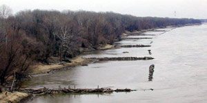
The Army Corps of Engineers installed these wing dams to force the current to the middle. The rushing water scours the bottom of the channel to keep navigation open. A new study alleges the wing dams slow the current during major floods and cause flood waters to be higher. Photo by Lester Graham.
A recent study concludes that some actions of the Army Corps of Engineers might be causing more, rather than less damage during major floods on rivers in the Midwest. The study by two Washington University professors found that wing dams, which jut out into the river, could cause big floods to rise even higher. The Great Lakes Radio Consortium’s Lester Graham takes a closer look at this study:
Transcript
A recent study concludes that some actions of the Army Corps of Engineers might be causing more, rather than less damage during major floods on rivers in the Midwest. The study by two Washington University professors found that wing dams which jut out into the river could cause big floods to rise even higher. The Great Lakes Radio Consortium’s Lester Graham takes a closer look at this study:
The Mississippi and the Missouri rivers are two of the major arteries for barge transportation in America. Millions of tons of grain, and raw materials are floated up and down the rivers each year. It’s the Army Corps of Engineers’ job to keep the rivers open to barge traffic. The Corps has been doing that job for the past 150 years. But since the 1930’s that effort has taken on immense proportions. Huge dams hold back the river, keeping the water high enough for the barges to travel up and down-stream. Big earthen dikes, called levees, wall in the rivers, keeping them from flooding farms and towns, but also keeping the water from reaching the natural flood plain. Robert Criss and Everett Shock studied flood levels and the effects of the Corps of Engineers projects. Criss says those dams and levees alone might be enough to disrupt the flow of the river and cause flood stages to be higher.
“But the other component is these structures called wing-dams which are jetties of rocks that project out perpendicularly into the channel. For high-flow conditions, these act something like scale in a pipe. They impede the flow, restricting the channel. That slows the velocity of the water down and that also makes the flood stages higher.”
The purpose of wing dams is to force the current to the middle of the river to scour out the navigation channel to keep it open for the barges. Researcher Everett Shock.
“So, they do the job they’re intended to do. It seems that there’s an unintended–perhaps unintended consequence of all these constructions along the river that shows up when we have a big flood and makes it to –on the basis of our study– makes these big floods worse.”
Criss and Shock say their study finds that since these flood control projects have been erected, there have been more big floods, such as the one in 1993 that flooded the Mississippi and some of its tributaries for most of the summer. Robert Criss.
“The fact is, before World War II, a flood stage of 38-feet is very rare and now it happens every five years.”
But not everyone agrees with the methodology used by the researchers. The
Corps of Engineers dismisses the researchers’ study, saying they used flawed data. Corps officials point to a study at the University of Missouri – Rolla. That study compared the 19th century method of measuring a river’s flow by timing how fast floats moved in the current to the methods used today. Dave Busse is a scientist with the Army Corps of Engineers. He says the original stream flow measurements –the ones Criss and Shock used— were inaccurate.
“The flows were over-estimated by 30-percent using this float measurements rather than the measurements than we use today.”
Criss and Shock are skeptical of new numbers that the Corps prefers. Saying it seems awfully convenient for the Corps because changing the numbers makes the historic floods look smaller and therefore makes the 1993 flood look unprecedented. Criss and Shock say based on the original records, there was as much water in past floods as in the 1993 flood but lower water levels. Criss and Shock say the difference between then and now is that the Corps’ big dams, levees, and wing dams constrict the river’s flow and make floods higher.
The Corps, however, has other criticisms of the Criss and Shock study. Dave Busse says the researchers ignored the role of the Corps’ reservoirs in the rivers’ watersheds. Busse says the reservoirs hold back water that would otherwise be part of a flood. And Busse says, another flaw is the researchers conclusions about wing dams. The Corps says the wing dams force water to deepen the channel and increases the flow of the river.
“So, what we have is the same –it’s a re-shaped river, but its carrying capacity is actually higher now. We can actually carry more water at the same stage. The river got deeper, therefore this conclusion that they’ve made is wrong.”
The Corps says there’s more to managing the river than the researchers have considered. Criss and Schock, meanwhile, say their study is not the first to be dismissed by the Corps of Engineers. They say other studies have found similar results, but the Corps dismissed them as well.
Environmentalists have been arguing for decades that levees and dams keep floodwaters from spreading out on their natural flood plains and cause higher flood levels. The Criss and Shock study adds to their arsenal of arguments to change the way the rivers are managed. But most environmentalists concede that we’ve become somewhat dependent on the Corps flood control projects. Chad Smith is with the environmental group,
American Rivers.
“In most ways both of these camps are right. The Corps is right that putting some of the structure in has helped to reduce the kind of annual flood events that always happen on a big river like this, but what they unfortunately have done is to exacerbate what happens when you have bigger floods and the wing dams and the levees and the dams themselves all are part of that.”
The Army Corps of Engineers says it’s reviewing its way of managing rivers in light of the 1993 flood. But they also note that while flood stages might be higher more often than they were in the 19th century, most of the time those floodwaters remain behind the floodwalls and levees, protecting the communities from high water, and the Corps says in the end, that’s the only fact that really matters.
The Army Corps of Engineers installed these wing dams to force the current to the middle. The rushing water scours the bottom of the channel to keep navigation open. A new study alleges the wing dams slow the current during major floods and cause flood waters to be higher. Photo by Lester Graham.
A recent study concludes that some of the flood control projects along the Midwest’s largest rivers might be making the severity of some floods worse. The Great Lakes Radio Consortium’s Lester Graham reports:
Transcript
A recent study concludes that some of the flood control projects along the Midwest’s largest rivers might be making the severity of some floods worse. The Great Lakes Radio Consortium’s Lester Graham reports:
The study, published in the journal Geology, looked at the history of flood stages and river flows along portions of the Mississippi and Missouri rivers. It concludes that the dams, dikes, and levees constrict rivers so that when there are massive floods, such as on the Mississippi in 1993, they make the situation worse. Everett Shock is a professor at Washington University and one of the authors of the study.
“There needs to be some very clever thought on how to go about some differences in management practices so that we aren’t making large floods worse.”
The Army Corps of Engineers, which built and maintains the flood control projects along rivers, says the study is flawed because it doesn’t use updated data and it doesn’t consider the role that man-made reservoirs play in holding backwater during floods. The Corps also notes that before the flood projects, the rivers often damaged homes, businesses and property on a large scale, something that the Corps says rarely happens now.
The gray wolf is making a comeback in the upper Midwest, and for some young wolves the area may be getting a little too crowded. It’s not unusual for young wolves to travel long distances to stake out a territory of their own, but as the Great Lakes Radio Consortium’s Mark Brush reports… one wolf’s trip has surprised everyone:
Transcript
The gray wolf is making a comeback in the upper Midwest. And for some young wolves the area may be getting a little too crowded. It’s not unusual for young wolves to travel long distances to stake out a territory of their own, but as the Great Lakes Radio Consortium’s Mark Brush reports… one wolf’s trip has surprised everyone:
The wolf was first seen two and half years ago as a young pup in Michigan’s Upper Peninsula. At that time he was caught in a trap, and wildlife officials tagged him as “Wolf No. 18.” They fitted him with a radio collar and followed his movements for nine months before they lost track of him.
About a year and a half… and over 450 miles later, the wolf’s luck came to an end. A bow hunter from central Missouri saw the wolf snooping around his sheep pen. The hunter shot and killed the wolf – apparently mistaking it for a coyote. He realized his mistake when he noticed the radio collar.
Typically, young wolves travel west or northwest from Michigan’s Upper Peninsula, so when Michigan Wildlife Division Supervisor Jim Hammill heard the news that one of their wolves had turned up in Missouri… he could only think of one explanation:
“My first reaction was that somebody possibly killed the wolf in Michigan and transported it to Missouri and they found the carcass of the animal down there… but that was not what happened… and you know this animal was seen alive in Missouri before it was killed, so you know, it’s obvious that this was a natural movement and, uh, really sort of a stunning thing to have happened.”
Stunning because Hammill has never heard of a wolf traveling this far south before. They’ve seen wolves travel as far west… and northwest, but typically those wolves have an easier trip. Wolf Number 18 would have had to overcome huge obstacles, such as a number of major highways, a number of rivers including the Mississippi, and large open spaces like farms.
Hammill says this wolf’s trip will likely shed some light on the gray wolf’s behavior. And that may be especially helpful to biologists in the northeast – a region that hasn’t heard the howl of a wolf for some time:
“A lot of folks up there feel that there’s no way that wolves could re-populate the area without a trap and translocation program. But, you know, I wonder about that because of the kinds of movements that we’ve been seeing here in the Midwest.”
Wolf 18’s body has been shipped back to a Michigan Department of Natural Resources lab. There – they’ll try to piece together just what this wolf encountered on his historic trip south. For the Great Lakes Radio Consortium, I’m Mark Brush.
A new study published in the journal Nature indicates that farmers could save fertilizer costs and pollute less while producing the same harvest. The Great Lakes Radio Consortium’s Lester Graham reports:
Transcript
A new study published in the journal Nature indicates that farmers could save fertilizer costs and pollute less while producing the same harvest. The Great Lakes Radio Consortium’s Lester Graham reports:
Researchers at the University of Illinois studied the use of nitrogen as a fertilizer on crop fields in the Mississippi River basin from the 1950’s to the 1990’s. Based on what they found, they think farmers could have reduced nitrogen fertilizer use by a relatively low 12 percent and kept harvest yields the same, yet reduced nitrate levels in the Mississippi river by a relatively high 33 percent. That might have significantly reduced the so-called dead zone in the Gulf of Mexico where the Mississippi carries the nitrates. Gregory McIsaac is the principle author of the study. He says farmers could reduce nitrogen use if for no other reason than saving money.
“Farmers have been applying more nitrogen than they need and they can reduce their fertilizer application and be better off, whether or not it has any impact on water quality.”
McIsaac notes a survey conducted last year found about 30 percent of Illinois farmers indicated they use more nitrogen than is recommended, hoping for better crop production.
For the Great Lakes Radio Consortium, this is Lester Graham.
A market in Cuba where growers sell what they don’t keep themselves. Photo
by Mary Stucky
While organic farming is growing across the U.S., the number of farmers in the Great Lakes using organic methods is still quite small – not so though in Cuba. In the past decade that island nation has embraced small-scale organic farming and urban gardens. Production of vegetables has soared, which has attracted attention from experts in the Great Lakes region who are visiting Cuba in increasing numbers. In the first of a two-part series, the Great Lakes Radio Consortium’s Mary Stucky went along with one group to find out how the country transformed its agricultural practices:
Transcript
While organic farming is growing across the U.S., the number of farmers in the
Great Lakes using organic methods is still quite small. Not so, though, in Cuba.
In the past decade that island nation has embraced small-scale organic farming and urban gardens. Production of vegetables has soared… which has attracted attention from
experts in the Great Lakes region who are visiting Cuba in increasing numbers. The
Great Lakes Radio Consortium’s Mary Stucky went along with one group to find out
what the Cubans can teach Midwest farmers about farming.
Cuban farmers had little choice about whether to embrace organic agriculture. Just seven
years ago, the Cuban people faced starvation, but today.
“For us, we are alive, we are alive.”
For Mavis Alvarez, and other Cubans, just having survived is an accomplishment.
When the Soviet Union collapsed, it had a ripple effect on Cuba as well. That’s because Cuba’s economy was based on financial assistance from the Soviet bloc, especially its food economy. And when that money stopped, Cuba’s citizens began to feel the effects. Before long, Cuba could no longer afford to import food, fertilizer or pesticides. So the government made a
drastic decision. Food would be grown without chemicals using alternative methods.
To many, it was seen as a major gamble…. but it worked.
(Natural sound from vegetable stand)
Vegetable stands in residential Havana display piles of lush vegetables at reasonable prices. While there are still severe shortages of meat and milk, the country is now producing four
times the vegetables compared to the worst year of the food crisis – and this is done largely without the use of chemical fertilizers and pesticides.
“I have so much respect for that and Cubans are evidently in the forefront.”
Diane Dodge is a master gardener from St. Paul, Minnesota. Among organic farmers, Cuba is
renowned – and many, like Dodge, are visiting the island to see Cuba’s methods with their own eyes.
“They’re not necessarily trying to change anything. What they’re trying to do is go with the
flow of nature and that’s very contrary to what we do. We’re always trying to manage nature, change nature and here it’s all of a piece.”
Cuba has combined organic farming methods including natural pest controls and
fertilizers… along with a vast new system of urban gardens like this one in Havana.
(Natural sound of windmill)
A windmill pumps water for this garden. Ten years ago this was a weed patch. Now it’s a lush
jungle of vegetables, spices and fruit… by law no chemicals can touch this soil. Through a translator gardener Ignacio Aguileras Garcias explains he feeds 10 family members from his plot.
“Here we have 43 farmers and maybe only 8 or ten sell the products. The rest use the products for their own consumption. You work on your piece of land and you do with your production whatever you want.”
Just a few short years ago many Cubans were starving. Nowadays most Cubans are eating well
enough to meet standards set by the United Nations. Some experts’ say that proves organic farming can feed a country’s people. Urban gardens produce more than half of the fruits and vegetables consumed in Cuba. Minor Sinclair lived in Cuba in the 1990’s. He represented Oxfam America, a charity working on food policy, and says it’s justified to use valuable urban land to grow food.
“You produce it locally, you get people involved in the production, you market it locally. You can go out and walk two blocks and buy a head of lettuce that’s been removed from the earth right there in front of your eyes. And that lettuce lasts a week in the refrigerator. Better product, cheaper prices and better income for the farmers too.”
So what those who came to visit the farms have found is that in ten short years Cuba has transformed its agriculture production… and that’s a good thing, says the Minnesota Department of Agriculture’s Wayne Monsen.
“You know they know how to feed themselves. I’m not sure Americans would know how to feed
ourselves if there was a crisis where the food supply stopped.”
But Cubans are looking beyond feeding themselves. In February, the first certified organic sugar
from Cuba was sold to European chocolate-makers. There’s a great demand in Europe for other
organic foods as well. If organics become a Cuban export bonanza, it would certainly get the
attention of farmers up north, in the Great Lakes.
For the Great Lakes Radio Consortium, I’m Mary Stucky.
Looking for an America with "substance," Mike Delano of Boston, along with
Ben Doornbos and Ethan VanDrunen (L-R) both from the Holland, Michigan area
are making their way down the Mississippi River on the 'Tom Sawyer and Huck
Finn of Michigan,' a homemade raft they hope will carry them to New
Orleans. Photo by Lester Graham
Inspired by Mark Twain novels, a trio of Huck Finns is taking a raft down the Mississippi river. They started their adventure where Mark Twain often did in his novels — Hannibal, Missouri. The Great Lakes Radio Consortium’s Lester Graham has the story:
Transcript
Inspired by Mark Twain novels. A trio of Huck Finn is taking a raft down the Mississippi River. They started their adventure where Mark Twain often did in his novels, Hannibal, Missouri. The Great Lakes Radio Consortium’s Lester Graham reports.
Looking at their raft, it appears to be a little precarious. Inspecting a little more carefully doesn’t inspire confidence. They’re thrilled to find that the 1947 pontoons that they patched with fiberglass don’t seem to be leaking. This little vessel, a small deck of not much more than plywood and two-by-fours with an even smaller roof overhead has been dubbed the Tom Sawyer and Huck Finn of Michigan. It says so in magic marker and poster board tacked to the wooden side rail of the raft.
Ben Doornbos and his friend Ethan Van-Drunen are from the Holland, Michigan area. The third member of the trio, Mike Delano is from Boston. The little raft is supposed to take its passengers from Hannibal, down the mighty Mississippi to New Orleans. Doornbos says their trip on a homemade raft is inspired by Mark Twain’s characters in The Adventures of Tom Sawyer, from the nineteenth century. But their reasons for launching the rickety craft seems to be more a reaction to frustration with the twenty-first century’s culture.
“We’re always griping about America and about kind of the loss of culture and how everything seems to look the same on the interstates. You know, it’s always McDonald’s here and, uhm, it’s just kind of– we wanted to find something else that was– had some substance, something that felt like something.”
We’re all sitting on lawn chairs on the raft, still on the trailer that hauled it to Hannibal. While his friend talks, Ethan Van-Frunen nods his head in agreement.
“I too, like Ben, am just kind of frustrated by cookie cutter America and mall culture and everything like that. And part of, like, what I hope to accomplish on the trip is seeing people who are, like, finding their identity and their culture and their past. So, that’s what I’m going to be looking for a lot on the trip is just talking with people who we meet along the way and what they’re interested in.”
As they try to explain their reasons for the trip, again and again the young men use the words “be free” and “freedom.” Each of them is twenty years old, quite a bit older than Mark Twain’s Huck Finn, but Mile Delano says really for all of them it’s the perfect time for an adventure before their freedom disappears.
“Right now I have no payments at all, car, apartment, insurance. So, I am completely free and this is the perfect time for that, so, I’m going to get on the river and get down to Louisiana.”
Van-Drunen and Doornbos built and tested the raft in Michigan. They noted when they slipped it into the still waters of a local lake that the raft rode deeper in the water than expected. They’ve been warned that the swirling currents and wakes of barge tow-boats can be unforgiving.
(Festival Band Sound)
The three friends have timed their trip to start during Tom Sawyer days in Hannibal. They even got to put their raft in the big parade. The local folks are a bit skeptical. They applaud the courage of the young men, but as David puts it,
“Well, I’ve been out on it on a boat before and I don’t think I’d want to do it on a raft, no.”
There are a lot of folks from all over the nation in Hannibal that come to see some of the sites mentioned in Mark Twain’s books. Standing across the streets from the site of the whitewashed board fence that inspired the story of Tom Sawyer persuading his gang to paint it and pay him for the privilege.
Larry Woodward shakes his head, he’s heard about the raft trip. He just brought his boat down from Wisconsin, and wonders whether the three friends know what they’re getting themselves into.
“I floated down in a 24-foot sailboat, but we were under power all the way with a diesel engine and I felt real intimidated by, particularly, the locks and the dams and a lot of places where the current could easily overpower my boat. So, I wish them luck, but it sounds like risky business to me.”
The three Huck Finns say they’ve been told the trip is a piece of cake. They’ve also been told they’ll likely get themselves killed. Mike Delano says they think the little craft has a fighting chance.
“We’re really hoping to raft to New Orleans, but I think we’re making our goal just to get to New Orleans, but if it doesn’t work out, we’ re just going to enjoy ourselves and, uh, no worries, I guess. We don’t want to have to worry about things like that. At least, I certainly don’t and I think I speak for all of us.”
His friend Ben Doornbos says, they feel a to like Huck Finn when he was adopted by Aunt Polly.
“He runs away from her. He talks about how it’s all too cramped in there and everything too civilized and he can’t stand it. And we’re just thinking the same thing. It’s time to get out and have some adventure.”
The trio says they’ve got six weeks for their adventure and they plan to use every moment. No matter how their raft, the Tom Sawyer and Huck Finn of Michigan fares.
A plan by the U.S. Army Corps of Engineers is
intended to stop invasive species from traveling between the Great Lakes and
the Mississippi river and its tributaries.
The government is trying to stop an invader from expanding from the GreatLakes into the Mississippi River system. The Great Lakes Radio Consortium’sLester Graham reports… the field of battle is a small channel nearChicago:
The Mississippi River is changing. Some fish and wildlife that once
lived in or around the river are gone and other plants and animals are
moving in. The Great Lakes Radio Consortium’s Lester Graham reports
researchers are finding that the flood of 1993 has accelerated those
changes: