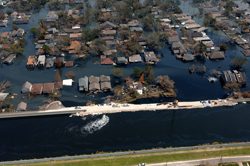
New Orleans on September 9, 2005. Crews worked on areas where there had been breaks in the levee in order to avoid additional flooding. (Photo by Jocelyn Augustino, courtesy of FEMA)
Four years after Katrina, the
levees around New Orleans are
still being constructed. But
a report by the National Academy
of Sciences says the city shouldn’t
think of the levees as a cure-all.
Mark Brush has more:
Transcript
Four years after Katrina, the
levees around New Orleans are
still being constructed. But
a report by the National Academy
of Sciences says the city shouldn’t
think of the levees as a cure-all.
Mark Brush has more:
Hurricane Katrina was one of the worst natural disasters in U.S. history. A big reason it was so bad is because the levees holding back the water crumbled.
There’s a big effort to build up the levee system, but the National Academy of Sciences says the city should not solely rely on levees to protect it.
Jeff Jacobs headed up the report for the National Academy.
“There is no levee system that can provide absolute protection. There’s always the danger of over-topping. And there’s always a possibility of levee failure. And that holds true for the best maintained and the best inspected levee systems in the world.”
The New Orleans area has a particular problem. The ground can sink over time. That’s not good for levees.
The Academy recommends that people relocate to safer areas. Or, if people are going to stay, that homes be elevated – so that the first floor of a home is higher than the floodwater.
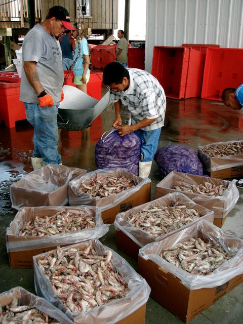
Shrimpers have seen their catches dwindle down from thousands of pounds of shrimp a day to very little due to the dead zone in the Gulf of Mexico. (Photo by Samara Freemark)
Of course, the bigger the zone, the further out shrimpers have to send their boats. That means a lot of wasted time, fuel, and wages. (Photo by Samara Freemark)
Every summer, thousands of
square miles of the Gulf of
Mexico die. The Dead Zone is
caused by pollution that flows
down the Mississippi River. It’s
runoff from factories, sewer
plants, and farms. And it causes
a lot of problems for fishermen
in the area. This year, the Dead
Zone is projected to be huge –
maybe the largest ever. Samara Freemark explains:
Transcript
Every summer, thousands of
square miles of the Gulf of
Mexico die. The Dead Zone is
caused by pollution that flows
down the Mississippi River. It’s
runoff from factories, sewer
plants, and farms. And it causes
a lot of problems for fishermen
in the area. This year, the Dead
Zone is projected to be huge –
maybe the largest ever. Samara Freemark explains:
Imagine for a moment you’re a shrimp fisherman. Every day you send out your fleet to the same waters you’ve fished for decades. And your boats pull in a lot of shrimp- thousands of pounds a day, millions a year. And then one day, a normal summer day, you send the boats out, and they come back empty.
“You go from about 5000 pounds to nothing. It’s dead. That’s why they call it the dead zone.”
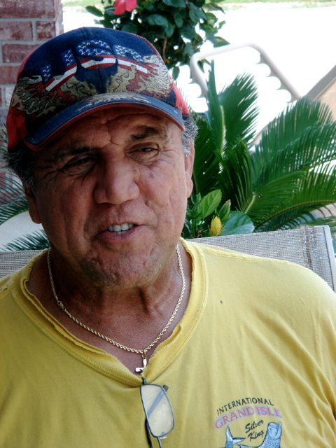
That’s Dean Blanchard. He runs the largest shrimp company in America- Dean Blanchard Seafood.
Blanchard started seeing the dead zone about five years ago, but it’s not a new phenomenon. For a long time, nutrient fertilizer from upstream has run into the Mississippi River and from there, into the Gulf. It fertilizes big algae blooms– and when the algae decays, it sucks oxygen out of the water, making it impossible for fish to live there.
What’s new is how much fertilizer there is now.
“It’s not natural.”
Nancy Rabalais is a marine biologist at LUMCON. That’s Louisiana’s center for marine research. She says that over the past several decades there’s been a surge in fertilizer use in the Corn Belt states. That eventually ends up in the Gulf.
“We’re having 300 times more than we did in the 1950s. And it’s just over loaded the system.”
Rabalais predicts this year’s dead zone will be almost three times as big as it was twenty years ago – more than 8000 square miles.
Of course, the bigger the zone, the further out shrimpers like Dean Blanchard have to send their boats. That means a lot of wasted time, fuel, and wages.
And the zones might mean even bigger problems. Don Scavia is a professor at the School of Natural Resources at the University of Michigan.
“There’s a half a billion dollar shrimp industry in the gulf. And the shrimp depend on that habitat. And what we’re concerned about is that if the dead zone continues or even grows, that fishery may collapse.”
Congress is taking some measures to address the problem. Conservation programs in the Farm Bill work to reduce how much fertilizer farmers use, and how they apply it.
But there’s something else in the Farm Bill too – a lot of subsidy programs. Those pay for ethanol production. Which means more corn. Which means a lot more fertilizer.
“And what is debated every 5 years is how much funding will go into those conservation programs, relative to funding going into subsidy programs. And, by far, the subsidies win.” (laughs)
Scavia says for every $1 spent on conservation programs in the Corn Belt, $500 go to subsidizing crops.
Shrimper Dean Blanchard says he’s not sure how long he can live with that balance, especially as he watches the dead zone grow.
“How big is this thing going to get? If we kill the oceans we have problems. We have serious problems.”
But Don Scavia is hopeful. He says we know exactly how to reduce nutrient runoff – in fact, the basic programs are already in place. It’s just a matter of Congress choosing the right funding priorities.
Choctaw Chief Albert Naquin has watched his tribe's island - the Isle de Jean Charles - go from four miles across to a quarter mile across. (Photo by Samara Freemark)
Naquin's Choctaw tribe has lived on the island since the 19th century. (Photo by Samara Freemark)
Twenty-five families still live on the Isle de Jean Charles. (Photo by Samara Freemark)
Over the next century, rising
sea levels will change coastlines
all over the world. But the impact
might be most dramatic in South
Louisiana. A study out last month
predicts the state will lose up to
5000 square miles in the next
century – a chunk of land the size
of Connecticut. If the report’s
authors are right, that means a
lot of people in Louisiana are
going to have to relocate – become
climate refugees. Samara Freemark has the story of one of
the first communities to be displaced:
Transcript
Over the next century, rising sea levels will change coastlines all over the world. But the impact might be most dramatic in South Louisiana. A study out last month predicts the state will lose up to 5000 square miles in the next century – a chunk of land the size of Connecticut. If the report’s authors are right, that means a lot of people in Louisiana are going to have to relocate – become climate refugees. Samara Freemark has the story of one of the first communities to be displaced:
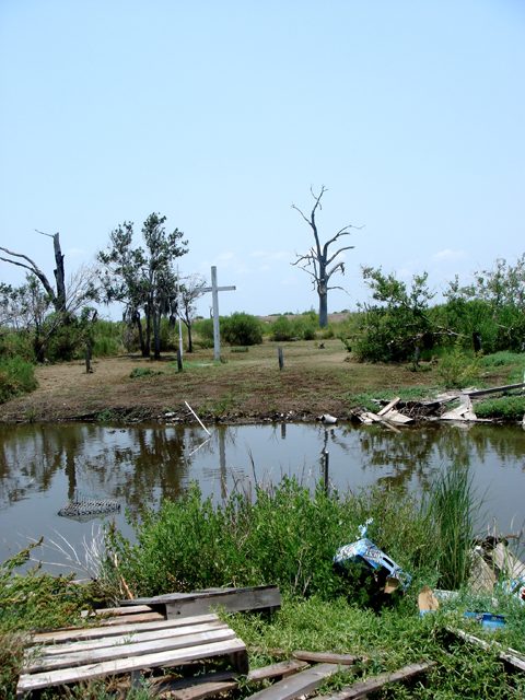
It was sometime in the mid-1970s that Albert Naquin first realized that Isle de Jean Charles was sinking. Naquin had grown up on the island. He’s the chief of a group of Choctaws who have lived there since the 19th century – and when he was a kid, it was a pretty good community: it had stores, a couple of churches, horse pastures and fields. But those are all gone now.
“Salt water kept coming in, faster and faster, and now it’s basically just beach.”
Isle de Jean Charles is sinking into the Gulf of Mexico.
The list of reasons why is long. There’s subsidence- that’s the natural phenomenon where delta regions kind of settle down on themselves. There are the dams that block the sediment that used to wash down and build the land back up. There are oil company canals that slice through the wetlands, hurricanes that tear up the island’s coastline, and, of course, there’s rising sea levels.
All together they explain why Isle de Jean Charles used to be about 4 miles across and now has shrunk to a quarter mile.
“Now, we see the disaster that is Isle de Jean.”
We’re in Naquin’s pickup truck, and he’s driving me out to the island.
“See this little house moved across the way, this house. These 1, 2, 3 are deserted.”
Naquin himself moved off the island awhile ago. But for years he was happy to support families who chose to stay. In fact, when the US government came to him in 2002 and offered to pay to help people move off the island, he resisted.
“So, I said, ‘what they gonna do, tell us they’re gonna move us there and then next thing send us a bill for the house?’ You know, so I said, ‘no, that’s just a modern day Trail of Tears. We’re not moving.’”
But lately Naquin has just gotten tired. Tired of evacuating people before storms, tired of helping them rebuild after, tired of watching the sea nibble away at the island.
And so he decided – enough. For the past year he’s been on a mission to convince the 25 families still living on the island to abandon it.
“They’re not going to save the island. It’s going to be gone. Either we move now or we move later, ‘cause we will move.”
But not everyone is ready to leave.
(sound of greeting and talking)
Naquin pulls over to talk to Dominique Dardar.
Dardar’s house was leveled by Hurricane Gustav last summer. He’s rebuilding it with pieces of other houses he’s found blowing around the island- bits of roof and siding. Dardar says he’s not moving.
“I ain’t never gonna move. I’m gonna stay over here. That’s my territory.”
Across the street Wenselas Billiot lives in a house raised 13 feet in the air.
Billiot is Naquin’s brother in law. He’s in his 80s and has lived on the island his whole life. I ask him what he’ll do if the island shrinks any more.
“That’s going to be rough. But, as long as I can stay, I’ll stay. I was born and raised on the island. As long as I can stay here I’m going to stay.”
Albert Naquin hasn’t given up. He thinks if he can get everyone to agree, the government will help the tribe get a big piece of land where they can all relocate as a group. He’s already thinking of names for the new town.
“We could say, Island Number Two, or Isle de Jean Charles New Beginning, or something like that. But I think we just name it Isle de Jean Charles 2. I think that has a good sound to it.”
In short, Naquin is trying to figure out how to keep the idea of Isle de Jean Charles alive, even when the island itself no longer exists.
It’s a challenge many Louisiana communities could soon face.
It is predicted that the dead zone in the Gulf of Mexico is the size of the state of Massachusetts (Photo courtesy of NASA)
About 40% of the continental U-S drains into the Mississippi River. It sends water – and pollution – from across the country into the Gulf of Mexico. A new study shows just who the worst offenders are. Gabriel Spitzer has the story:
Transcript
About 40% of the continental U-S drains into the Mississippi River. It sends water – and pollution – from across the country into the Gulf of Mexico. A new study shows just who the worst offenders are. Gabriel Spitzer has the story:
All the pollution creates a dead zone in the Gulf nearly the size of New Jersey.
Nitrogen and Phosphorus pour in and fertilize big algae blooms.
When that stuff decays, it sucks oxygen out of the water, and makes it impossible for most fish to live there.
US Geological Survey researchers say most of the problem comes from farm runoff, but the single biggest source is sewage from Chicago.
Albert Ettinger with the Environmental and Law Policy Center says Chicago water managers have to catch up with their neighbors.
“They’re gonna have to look at treatment systems which take nitrogen out of the water, and bring phosphorus down to one milligram per liter. It’s done in Milwaukee, it’s done in Cleveland, it’s done in Detroit.”
Chicago’s Metropolitan Water Reclamation District say they haven’t had a chance to look closely at the study yet, so they don’t want to comment on it.
It is predicted that the dead zone in the Gulf of Mexico is the size of the state of Massachusetts (Photo courtesy of NASA)
A scientific panel wants two
federal agencies to start working together,
to reduce pollution. Fertilizer pollution
is causing problems for the Mississippi
River system and contributing to a ‘Dead
Zone’ in the Gulf of Mexico. Chuck Quirmbach
reports:
Transcript
A scientific panel wants two
federal agencies to start working together,
to reduce pollution. Fertilizer pollution
is causing problems for the Mississippi
River system and contributing to a ‘Dead
Zone’ in the Gulf of Mexico. Chuck Quirmbach
reports:
Nitrogen and phosphorus come from fertilizers used on lawns and farm fields. The chemicals
pollute water throughout the Mississippi River Basin and down to the Gulf of Mexico. The
National Research Council has been studying the problem.
David Dzombak is an Engineering Professor at Carnegie Mellon University, and helped the
council write a new report. He says the biggest recommendation is for the US Environmental
Protection Agency and the US Department of Agriculture to team up.
“This is a very large scale problem. It’s taken many years to develop and will take many years to
turn around.”
And Dzombak says the two agencies need to get started. The report recommends the federal
agencies work with states to restrict the amount of fertilizer that can go into streams and rivers. It
also calls for a network of experiments to filter or buffer the fertilizer runoff in badly-polluted
watersheds.
It is predicted that the dead zone in the Gulf of Mexico is the size of the state of Massachusetts (Photo courtesy of NASA)
Environmental groups are
petitioning the government to limit
pollution from farm fields in states
that drain into the Mississippi River
and its tributaries. The pollution
contributes to a so-called ‘Dead Zone’
in the Gulf of Mexico. Chuck Quirmbach
reports:
Transcript
Environmental groups are
petitioning the government to limit
pollution from farm fields in states
that drain into the Mississippi River
and its tributaries. The pollution
contributes to a so-called ‘Dead Zone’
in the Gulf of Mexico. Chuck Quirmbach
reports:
Nine groups from states bordering the Mississippi River are calling for standards
to limit nitrogen and phosphorus pollution. The main source of the chemicals
is runoff from farms.
Attorney Betsy Lawton is with Midwest Environmental Advocates.
She says it’s been ten years since the Environmental Protection Agency said it
would make states in the Mississippi Basin protect and clean up the waters.
“EPA has long held that it would step up and take action when states failed to do.
It has set several deadlines for states to take this type of action and limit this
pollution but has let the states slide from those deadlines.”
The nitrogen and phosphorus flow down the Mississippi into the Gulf Dead Zone
– an oxygen depleted area of about 8,000 square miles – or the size of the state
of Massachusetts.
It is predicted that the dead zone in the Gulf of Mexico could be the largest ever (Photo courtesy of NASA)
A researcher is predicting farm
fertilizers will cause record “Dead Zones”
in the Gulf of Mexico and Chesapeake Bay
this year. Lester Graham reports:
Transcript
A researcher is predicting farm
fertilizers will cause record “Dead Zones”
in the Gulf of Mexico and Chesapeake Bay
this year. Lester Graham reports:
These dead zones are areas where oxygen is depleted. No oxygen and much of the
marine life leaves or dies. It’s caused by nitrogen-based farm fertilizers that are
washed off the fields and into the water.
Donald Scavia is a researcher at the University of Michigan. Using U.S. Geological
Survey data, he predicts the dead zone in Chesapeake Bay will be the sixth largest
on record.
“The six other ones are also not that much bigger than what we’re predicting for this
year.”
Heavy rains and flooding across the Corn Belt washed nitrogen fertilizers into the
Mississippi River system and then on to the Gulf of Mexico. Scavia predicts the
dead zone in the Gulf could be the largest ever.
“What you put down on the land is what gets flushed in those rainstorms. And we’re
putting too much fertilizer on the land. So,
what’s changed over the last three decades is agricultural practices. What changes
from year-to-year is the weather.”
Scavia says better methods of farming could reduce the dead zones.
For The Environment Report, this is Lester Graham.
Parkinson’s Disease has been in the news a lot recently ever since
actor Michael J. Fox announced that he’s a victim of the disease.
Scientist have been studying Parkinson’s for years, but still haven’t
determined what causes the tremors and other symptoms. But now, one
researcher thinks he may know the answer…and beginning this January,
he’ll begin to test his theory. The Great Lakes Radio Consortium’s Todd
Witter has more:
 New Orleans on September 9, 2005. Crews worked on areas where there had been breaks in the levee in order to avoid additional flooding. (Photo by Jocelyn Augustino, courtesy of FEMA)