Costs of Building in Danger Zones

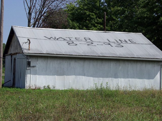
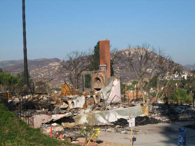
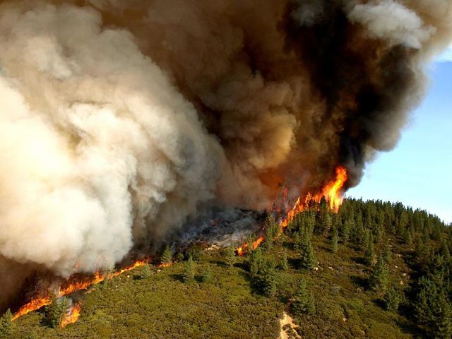
  • In San Diego’s suburbs, the homes on the outer edges of developments and in close proximity to the surrounding countryside are the first to burn. (Photo by Lisa Ann Pinkerton)

During the past 20 years, we’ve been building
homes closer to nature. Whether it’s near coastal areas
or in the wilderness, homebuyers want to live in more
natural settings. But… Lisa Ann Pinkerton reports
often that means putting people and property in the path
of floods or fire:

Transcript

During the past 20 years, we’ve been building
homes closer to nature. Whether it’s near coastal areas
or in the wilderness, homebuyers want to live in more
natural settings. But… Lisa Ann Pinkerton reports
often that means putting people and property in the path
of floods or fire:

2007 was the second worst in history for wildfires in the U.S. Nine-million acres were
scorched and Southern California bore the brunt of it. Most of the property damage was
in San Diego where wildfires in wilderness areas spread to suburban neighborhoods. Half a
million people were evacuated and Shannon Denton was among them. She says her
neighborhood was cleared out at 4 in the morning.

“We were scared. ‘Cause we didn’t – luckily we had all our pictures organized, so we just took most of our pictures and our video stuff, grabbed our kids at the last minute and left within a half-hour. It was scary, very
scary.”

(construction sound)

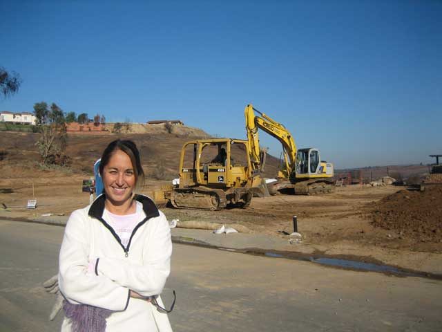
These days, Denton’s subdivision is busy. There are bulldozers demolishing the burned
out remains of old houses. And construction crews are building new ones on every single
street.

Denton’s thankful her house was spared. But she says even if it had burned down, she’d
take the risk of it happening again, because she likes living here.

“It’s pretty close to nature. There’s a lot of walking and hiking, a lot of mountains that you can take trails and different things.”

Despite the risk of fire, people like Denton don’t want to leave. Some of the 18-
thousand homes lost in San Diego last fall were built in places where wildfires had
burned only four years earlier.

That’s not unusual. The US Fire Administration says nearly 40% of new home
development across the country is in places where residential homes and wilderness meet,
and thus, are more prone to fire.

“They have a right to build that single family home.”

That’s Jeff Murphy of San Diego County’s Department of Planning.

“As a jurisdiction its our responsibility to have codes and ordinances that are
in place to make sure that there’s minimal structural damage as the result of wildfire and minimize
the risk of loss of life.”

Murphy says people are going to live where they want to, all government can do is
require smart development. And San Diego’s building codes are the most restrictive in
the California. They were reevaluated after the 2003 wildfires, when seven percent of the
homes were destroyed.

In the 2007 wildfires, Murphy says the new codes reduced that loss to one-percent.

“Even though we had a lot of structure loss during these fires, what these
numbers are showing us is that our codes are working.”

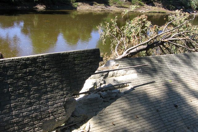
And Americans aren’t just building in areas at risk of fire. We build in flood zones, too.
FEMA estimates around 10 million people in the US are at risk of flooding. And
according to the United Nations, we saw the most floods of any country last year.

Roger Kennedy is a former director of the National Park Service. He says this kind of
“risky living” costs US taxpayers about two-billion dollars a year in firefighting and
rebuilding costs. The total in property damage hovers around 20 Billion.

Kennedy says people are choosing to build and live on land that’s in danger-prone areas
because they’re not responsible for the true costs. Insurance, guaranteed mortgages, and
federal disaster relief have reduced the personal financial risk.

“People wouldn’t settle in places from which they knew they would not be
rescued and where the taxpayers wouldn’t pick up- or the insurance company which is
essentially the same thing- wouldn’t pick up the tab.”

Kennedy says knowing about a home’s potential risk might reduce the material cost of
fires and floods. And, it might save lives.

But he says, people have to want to know their risks. And even then… they might choose
to ignore it. Because for many, the enjoyment their property brings far outweighs the
occasional “Act of Nature.”

For the Environment Report, I’m Lisa Ann Pinkerton.

Related Links

West Nile Virus Returns

West Nile Virus has swept the nation from east to west, but it’s hitting some areas
harder than others. Lester Graham reports:

Transcript

West Nile Virus has swept the nation from east to west, but it’s hitting some areas
harder than others. Lester Graham reports:


Nationwide this year, there have been 576 cases of West Nile Virus reported in humans this
year. The mosquito-borne disease has spread across the nation. Emily Zielinski-
Gutierrez, with the Centers for Disease Control, says some areas are worse than
others. There are West Nile Virus hotspots in the Dakotas and Nebraska, but it can
pop up anwhere… especially where there’s been a lot of rain or flooding:


“Basically, if you’re anywhere in the United States, you need to worry about a
mosquito bite that you get. If you’re in these states that have experienced and
communities that have experienced more intense activity, you need to be even that
much more concerned about protecting yourself from mosquito bites.”


She says look for the ingredient DEET in mosquito repellant. The CDC warns just
because you’ve not heard a lot about West Nile Virus in the news this year doesn’t mean it’s
not a problem in your area.


For the Environment Report, this is Lester Graham.

Related Links

Inner City Church to Turn Water Into Heat?

Underground mines that were abandoned long ago are coming back to haunt the people and places above them. The voids and toxic metals left behind are posing new kinds of environmental challenges. But one church that was almost destroyed by a mine is now trying to turn it into a new kind of green resource. Katherine Fink reports:

Transcript

Underground mines that were abandoned long ago are coming back to haunt the people and places above them. The voids and toxic metals left behind are posing new kinds of environmental challenges. But one church that was almost destroyed by a mine is now trying to turn it into a new kind of green resource. Katherine Fink reports:


John Wesley A.M.E. Zion Church is on a street where cars don’t stop. Crime rates are high here. A faded sign with graffiti on it indicates where a convenience store used to be. Most of the church’s stained glass windows are either missing or covered with plywood. Pastor Calvin Cash says he remembers when things were different.


“This was once a thriving community. Stores, residential homes, businesses, the whole bit.”


Cash was first assigned to the church in 1996. It had been closed for a couple years. He found 18 inches of orange water in the basement. Moss was growing on the walls. Cash says church leaders had known about the water problem, but thought they had it under control.


“For years, they had sump pumps down in the basement. And when the water reaches a certain level, the sump pumps would come on, and carry it away.”


Meanwhile, state environmental workers were investigating another mysterious pool of water down the street. They suspected an old underground mine had filled with water and was starting to burst. One of those workers, Charles Johnson, noticed the church nearby.


“I left a card inside of the mailbox with my number on it and said if you are having any water problems in your basement, give me a call… so within two days, reverend Cash gave me a call and said, ‘you got to see this.'”


Mine-related issues are not new for the Pittsburgh area, which has one of the largest coal seams in the country. But water problems like these are becoming increasingly common as more and more mine voids fill to capacity. Johnson says in the church’s case, the need for a fix was urgent.


“The pressure on the building from the water; it was just a matter of time before the pressure would just collapse the whole building.”


Workers redirected the water into local storm sewers, relieving the pressure on the church.


Since then, Johnson says they’ve learned that mine water can actually be useful. Its constant 57-degree temperature makes it an attractive candidate for geothermal heating, which uses the earth’s natural warmth.


George Watzlaf with the National Energy Technology Laboratory has studied the idea.


“We could probably reduce their heating and cooling costs 60, 70, maybe 80 percent; the annual cost.”


Geothermal heat is becoming increasingly common as a lower-cost alternative to natural gas. Pipes filled with an antifreeze solution carry heat from deep in the earth up into buildings. Instead of using antifreeze, Watzlaf says he wants to build a system that draws in mine water:


“We’re trying to put together a small project where we price everything out to say, okay, all we need is $10,000 to go out and put in a small system somewhere, heat a shed or something like that. Just to, no pun intended, get our feet wet and just learn some things about some of the potential problems and how we can overcome those problems.”


Reverend Cash wants his church to be that demonstration project. Since learning about geothermal heat and its potential cost savings, Cash is convinced it could save his blighted neighborhood. He’s become a convert to all things green.


“We are responsible for this world, and God expects us to take care of it.”


On this night, Cash is holding a workshop at the church to help residents learn how to make their homes more energy efficient. Only one person came. Trays full of untouched sandwiches, fried chicken and cookies are being wrapped up for another day, but reverend Cash says he’s not discouraged. Sometimes, he says it takes something big to get people’s attention:


“One of the best proofs of it, when they were taking that water out of there, we had all that heavy equipment active out there, and if 10 cars went by, nine of then slowed down or stopped to see what was going on. And I think when we start building back this community, that curiosity will grow, and benefit us. So we’ll hold on and see.”


Cash is hoping to convince the state to have faith in geothermal heat. His church is applying for a grant this year.


For the Environment Report, I’m Katherine Fink.

Related Links

The Costs of Preventing Flood Damage

  • A shed in Valmeyer, Ill. shows how high the water got during the 1993 Flood. The flood waters caused such damage that most of the town moved a few miles east, high up on a bluff. A few residents and many farmers, though, stayed in the flood plain. (Photo by Tom Weber)

It’s been 13 years since the Great Flood of ’93 caused widespread destruction along the upper Mississippi River. After the flood, there was talk of needing to expand the natural floodplain by eliminating levees that protect farmland. That didn’t happen. In fact, not much of anything has happened, but that doesn’t stop farmers from wondering if the government will buy their farms and turn them into natural areas designed to take the waters of the next big flood. Tom Weber reports:

Transcript

It’s been 13 years since the Great Flood of ’93 caused widespread destruction along the
upper Mississippi Rivers. After the flood, there was talk of needing to expand the natural
flood plain by eliminating levees that protect farmland. That didn’t happen. In fact, not
much of anything has happened, but that doesn’t stop farmers from wondering if the
government will buy their farms and turn them into natural areas designed to take the
waters of the next big flood. Tom Weber reports:


For all the river talk in these parts, it’s actually kind of hard to see the water. Doug
Sondag’s farm is about about two miles from the river and his view to the west
is of the bluffs, on which Missouri towns, like Herculanium, sit.


“That’s Missouri bluffs. That’s Missouri bluffs, and to the north the bluffs that you see is Missouri.
We’re on a big bend here.”


Doug’s friend Ron Kuergeleis is visiting the farm today. Kuergeleis lost his home in the
’93 flood, but he still farms on the flood plain near Valmeyer, Illinois. The two also are
commissioners with the local levee district, which means they’re in charge of keeping the
local levee up-to-date so the river is kept away.


Today, though, they’re talking about the possibility of a new federal levee and something
called “Plan G.”


(Ron): “You’re talking quite a few farmers that would absolutely put them out of
business. You’re one of them, I’m one of them, and there’s – (Doug): “There are quite a few
more.” (Ron): “There are quite a few more.”


No one is going out of business any time soon, though. Plan G is something the Army
Corps of Engineers studied and decided wasn’t worth the money. It would have the
Corps spend billions building up bigger levees along the upper Mississippi to 500-year
levees: the highest levees the Corps builds.


Plan G also would create a huge storage district nearby. A storage district is a kind of
relief area where flood waters go to take strain off other levees. Corps engineer Richard
Astrack says design elements like these can help control flooding in other places:


“Now we have the capability that we didn’t have before to look at whole system to ensure
that actions taken at one location can impact another location.”


The Valmeyer storage district would require a new levee in the flood plain, which would
leave 10,000 acres of currently protected farmland unprotected and on the wrong side of
the levee.


This all started a few years ago, when Congress told the Corps to study the entire Upper
Mississippi River, from Illinois’s southern tip to Minnesota, find out if the current levees
are good enough to reduce flood damage. If not, should there be some comprehensive plan to guide just which levees get built up and when? Such a study actually had never been done.


The Corps’ Richard Astrack says they looked at a lot of options, including that Plan G,
to see if any of them were worth the time and money. And it turns out, none of them is:


“None of the plans passed that test. Our draft report does not
recommend any systemic plan.”


And the Corps’s final report will probably recommend essentially doing nothing because
the current system does a good enough job of preventing flood damage. The Corps will
recommend updating, but not raising, current aging levees, and also creating some mini-
levees to protect roads that approach bridges.


But even with all the assurances that Valmeyer, Illinois is safe for now, farmers in the
bottomlands are worried that the federal government might one day force their children
or their grandchildren off their farms.


Ron Kuergeleis is a fourth generation farmer:


“We’re pretty much assured in our lifetime it ain’t gonna happen. But some of us got another
generation coming up and you don’t know. He claims, you know where you going to
come up with money, but if they want to come up with it, they’ll find it.”


The worries stem from the fact that Corps cannot, in all fairness, guarantee that such a
levee would never be built. Because setting aside some of the bottom lands for natural
flooding could protect big cities such as St. Louis, Missouri and Memphis, Tennessee,
there’s concern that Congress might one day instruct the Corps of Engineers to buy out
those farms.


So, while Valmeyer is not getting a new levee right now, the people here say they’ll keep
working to stay one step ahead to make sure it never happens.


For the Environment Report, I’m Tom Weber

Related Links

Faulty Flood Walls Spring Problems

  • Donna Smrdel stands in her backyard by the "flood wall." (Photo by Julie Grant)

Many people are drawn to live near rivers, lakes and other bodies of water. That means they have to take special care in case of floods, but flood walls and levees don’t always protect them. In one town, residents are asking why the wall separating their backyards from the neighboring river didn’t hold back the water. The GLRC’s Julie Grant reports on the safety of floodwalls and building in a floodplain:

Transcript

Many people are drawn to live near rivers, lakes and other bodies of water. That means
they have to take special care in case of floods, but flood walls and levees don’t always
protect them. In one town, residents are asking why the wall separating their backyards
from the neighboring river didn’t hold back the water. The GLRC’s Julie Grant reports on
the safety of floodwalls and building in a floodplain:


Dale and Donna Smrdel bought a condominium along a river just a few months ago.
This summer they’ve been sitting in the backyard on a wall overlooking the river and
watching the sunset. But now, that concrete wall is broken and falling away from the
bank. It’s crumbled in some spots and held together only by twisted rebar.


“This is where the largest portion simply fell away because of the water. It was a torrent.
It was so strong it picked up a camper and flung it over this wall. Because the water was
so high above the wall, that it was like a toy. It just floated away like a toy.”


People on rafts rescued everyone from
second floor windows. Donna Smrdel says they thought this wall would protect them
from flooding:


“I don’t think there was a single person here that believed this was not going to keep us
safe. I think we all believed that even if the water did rise that it wouldn’t hurt the
retaining wall. None of us are engineers. We looked at it, it looked safe. We believed
we were safe. We had no idea, we just had no idea.”


This story is not uncommon. Last year, people in New Orleans expected a flood wall to
protect them from rising waters brought on by Hurricane Katrina. People along the
Mississippi River expected levees and flood walls to protect them from the Great Flood
of ’93. Many flood walls hold, but when they don’t, the people who thought they were
protected quickly find out they’re victims. In the case of the Smrdels, it turns out that
wall wasn’t even meant to protect them from high water.


Painesville City Manager Rita McMahon says the Smrdels live near the exit of the river,
where ice often jams in spring:


“Well, that wall was built by the private property owner as actually a flood protection
from ice dams. It wasn’t intended to protect the property from this type of a flood. This
was a volume flood that came from the south to the north. It was just a wall of water, so
to speak.”


The Smrdel’s condo community was built in the 100-year floodplain 30 years ago. Back
then, there weren’t regulations on building in a flood-prone area. Today, new buildings
have to be elevated.


That’s better protection then a wall, but flood walls and levee protection give people a
sense of security. Often they don’t think about that protection failing them, and the
consequences of what that failure will mean to their homes and families. Engineers say it
is possible to live safely by the water, but homeowners have to do their own investigating
to find out the safety of housing elevations and flood walls. We spoke with Carm
Marranka, a structural engineer with the US Army Corps of Engineers:


Julie: “When you look at Katrina, when you look at the Mississippi floods in ’93, and when we
look up here, do you think that sometimes flood walls, even those built by the Army Corps,
provide a false sense of security?”


Marranka: “I don’t know if it’s a false sense of security. I think
with the design and assumptions that I’m familiar with the factors of safety, those
structures are built at. And good maintenance, I think that’s a big issue. They have to be
maintained. They cannot be allowed to fall into disrepair.”


When the Army Corps builds a flood wall, Marranka says it’s usually up to the local
community to maintain it, but the local governments often don’t have enough money to
pay for that maintenance. Donna Smrdel doesn’t trust any of it anymore:


“I mean, even if they bulldozed it, what kind of retaining wall will they build next? If
this didn’t work, and we all believed it would work, what do you build next?”


All those other people flooded out of their homes will also have to decide whether they
trust flood prevention technology, and if living by the beautiful scenery is worth the
threat of floods.


For the GLRC, I’m Julie Grant.

Related Links

Putting a Price Tag on Urban Trees

  • Volunteers with the Greening of Detroit plant about 4,000 trees each year in the city. (Photo by Sarah Hulett)

Money might not grow on trees. But researchers at a think tank devoted to saving America’s forests say dollar signs can be attached to all those oaks, maples, and sycamores. They’re hoping their environmental calculus can help convince local governments that it’s in their best interest to protect the trees they still have, and to plant new ones.
The GLRC’s Sarah Hulett reports:

Transcript

Money might not grow on trees. But researchers at a think tank devoted to saving
America’s forests say dollar signs can be attached to all those oaks, maples, and
sycamores. They’re hoping their environmental calculus can help convince local
governments that it’s in their best interest to protect the trees they still have, and to plant
new ones. The GLRC’s Sarah Hulett reports:


If trees could unionize, they’d be able to put together a pretty compelling case for hefty
compensation packages from the cities where they work. That’s the general idea behind a
series of reports put together by the advocacy group American Forests. The organization
looked at the amount of tree-covered land in several US cities and for each city, it put
together a dollars-and-cents case for their protection.


Trees in Detroit got a recent appraisal from the group. Trees shade more than 31 percent
of the city. Besides helping to keep the city cool, the report says Detroit’s trees take out
two million pounds of pollution out the air every year. That’s worth about five
million dollars. And it said if the city’s trees were gone, the city would have to build 400
million dollars worth of storm water drains. That’s because trees act as buffers during
heavy rains, and help control flooding.


Cheryl Kollin is the Director of Urban Forestry at American Forests. She says the bottom
line for politicians and city planners is money. She says they’re not going to save trees
just because they’re nice to look at:


“And I think it’s really building that awareness that trees — as wonderful and beautiful as
they are for their aesthetic qualities — it’s so important to connect the ecological
properties that they have and the economic benefits they provide. Because it really is going to
be that economic argument that makes decision-makers do things differently.”


Like a lot of cities, Detroit relies on a non-profit group to raise money for urban
reforesting. Today, the Greening of Detroit is planting trees around a recreation center in
one of the most polluted areas of the city, where diesel soot from heavy truck traffic
contributes to a high asthma rate.


Rebecca Salminen-Witt is the director of the Greening. She says this is a critical time for
this struggling rust belt city:


“We want to see some development in Detroit. We want to prove to outsiders that good things are
happening here in a visual way. Any development is good development, right? And, you know, that
is simply not true.”


Witt says as the city seeks to rebound, the focus can’t just be on new buildings. She says
it’s important that planners and developers figure trees and green space into Detroit’s
future and she says the American Forests’ economic data and satellite images will help
her make that case:


“Having those statistics, and having that visual representation of this is what it looks, you know, here’s your
heat island effect with trees and without trees.”


That visual picture of tree loss proved especially powerful in the nation’s capital.
American Forests surveyed Washington, D.C.’s trees in 1999. Its report said the city lost
nearly two-thirds of its tree cover between 1985 and 1997.


The Washington Post published the before-and-after satellite photos. They showed huge
swaths of black gobbling up what a dozen years earlier looked green from far above the
earth. It looked like a cancer had wiped out the healthy parts of the city whose slogan is
the “city of trees.”


“That got the attention of a variety of people. One person in particular was Betty Casey.”


That’s Dan Smith of the Casey Tree Endowment Fund. The group was established thanks
to a 50 million dollar contribution from Betty Casey, the widow of developer Eugene B.
Casey:


“And I believe the contribution was if not the largest gift ever for environmental action,
certainly one of the largest.”


That sort of cash gift is a dream for most cities. But the Greening of Detroit’s Rebecca
Salminen-Witt says she does expect to be able to use the information from American
Forests to raise money. And she says it will also help her small organization figure out
which parts of the city are the most in need of trees:


“We have to decide where we’re going to allocate our resources. And having a tool that makes
allocation of resources in an area where there’s a great need easier, or make more sense, is
really important to a non-profit organization.”


Witt says her first pitch will be to the corporations and civic leaders planning a
redevelopment along Detroit’s riverfront. Witt says the plans she’s seen call for some
trees and green space. But armed with satellite pictures and economic data, she hopes
she’ll be able to make the case for a few more trees.


For the GLRC, I’m Sarah Hulett.

Related Links

Putting a Price Tag on Urban Trees (Short Version)

A non-profit group devoted to saving America’s forests is putting a dollar value on cities’ trees in an effort to convince local planners
to save existing trees and plant new ones. The GLRC’s Sarah Hulett has this report:

Transcript

A non-profit group devoted to saving America’s forests is putting a
dollar value on cities’ trees in an effort to convince local planners
to save existing trees and plant new ones. The GLRC’s Sarah
Hulett reports:


The group American Forests has compiled reports for more than
two dozen US cities. The studies use satellite images to see how
most cities are losing trees over time. They also put a price tag on
the work trees do for a city.


Rebecca Salminen-Witt is the director of a non-profit tree planting
group called the Greening of Detroit. She says people appreciate
the beauty of trees. But she says they need to be shown there’s an
economic need for trees:


“They want us to come, they contact us constantly, they give us
their time and their money. So we know how important it is to
them. But the evidence we really have is anecdotal.”


American Forests says it can show that cities’ trees can be worth
hundreds of millions of dollars for the work they do cleaning
pollution out of the air and helping to control storm water.


For the GLRC, I’m Sarah Hulett.

Related Links

LOW-COST SEWER SOLUTIONS (Short Version)

Cities throughout the country are spending millions of dollars to rebuild aging sewer systems. But in some communities, a trend called “low-impact design” is making these projects more affordable for taxpayers, and better for nature. The GLRC’s Erin Toner reports:

Transcript

Cities throughout the country are spending millions of dollars to rebuild
aging sewer systems. But in some communities, a trend called “low-
impact design” is making these projects more affordable for taxpayers,
and better for nature. The GLRC’s Erin Toner reports:


Low-impact design focuses on restoring natural ways to manage storm
water, instead of building sewer systems that send polluted water straight
to rivers and streams.


Rain gardens are one feature of low-impact design. They’re bowl-
shaped gardens planted with native flowers and grasses. Water collects
in the gardens and becomes cleaner as it seeps through the soil.


Pat Lindemann is a county drain commissioner in Michigan. He’s using
low-impact design to deal with flooding problems, and to clean up local
waterways.


“If we can take neighborhood by neighborhood, one rain garden at a
time, one constructed wetland at a time, manage our storm water, polish
it, clean it, discharge it at a lower rate, our rivers will start to recover.”


Lindemann says he’s done two low-impact design projects at half the
cost of rebuilding drainage systems with concrete pipes, curbs and
gutters.


For the GLRC, I’m Erin Toner.

Related Links

Study: Black Mold Affects Sense of Smell

That black mold you sometimes find in wet basements might cause more trouble than you think. New research finds that toxins produced by black mold are capable of killing cells that help us smell. The GLRC’s Erin Toner reports:

Transcript

That black mold you sometimes find in wet basements might cause
more trouble than you think. New research finds that toxins
produced by black mold are capable of killing cells that help us
smell. The GLRC’s Erin Toner reports:


Toxins found in the spores of black mold have been linked to
respiratory and neurological problems. But now, researchers at
Michigan State University have found that the toxins also affect
the nasal passages.


Veterinary Pathologist Jack Harkema was one of the researchers.
He says in the study, mice were given a small, single dose of black
mold toxin.


“When we examined these animals, we found that the cells that are
important to detect odors, or the sense of smell, that within 24
hours they died.”


Harkema says the toxins killed nearly 80 percent of nasal cells that
send signals to the brain. He says more research is needed to better
understand the effects of the toxin on people. That could be
important for thousands who’ve been affected by flooding,
including the disaster caused by Hurricane Katrina.


For the GLRC, I’m Erin Toner.

Related Links

Funding Dries Up for Corps Project

Funding has dried up for a U.S. Army Corps of Engineers study designed to show where, when, and how often it might flood along the Mississippi, Illinois, and Missouri rivers. The Great Lakes Radio Consortium’s Rich Egger reports:

Transcript

Funding has dried up for a U.S. Army Corps of Engineers study designed to show where, when, and how often it might flood along the Mississippi, Illinois, and Missouri rivers. The Great Lakes Radio Consortium’s Rich Egger reports:


After a whistleblower revealed the
Corps overstated the economic
benefits of its projects, Congress cut
the agency’s budget. That’s meant a
shortage of money for research, such
as this flood study. Supporters of the
research believe another large flood
is inevitable.


Heather Hampton-Knodle is with the
Upper Mississippi, Illinois, and
Missouri Rivers Association. She
says it’s important to finish the study:


“It’s the notion that we need to build the Ark before the flood…and be prepared to protect our citizens and keep our economy flowing in the case of that sort of major
disaster. This is one disaster we can
plan for.”


Funding was frozen this summer just
before the report was completed. Researchers
say they need just another $142,000
to finish the eight-and-a-half million
dollar study.


For the Great Lakes Radio
Consortium, this is Rich Egger.