Predicting Wildfires in a Warmer World

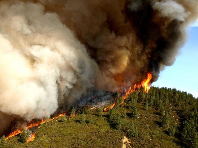
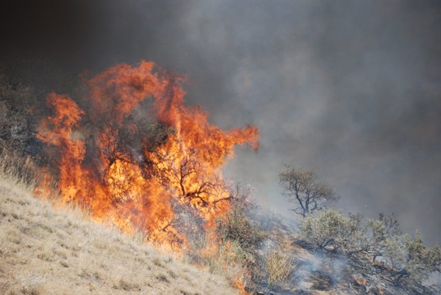
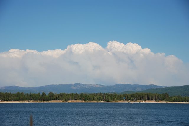
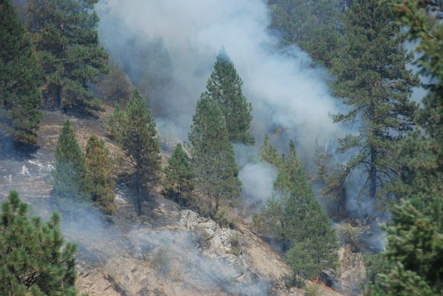
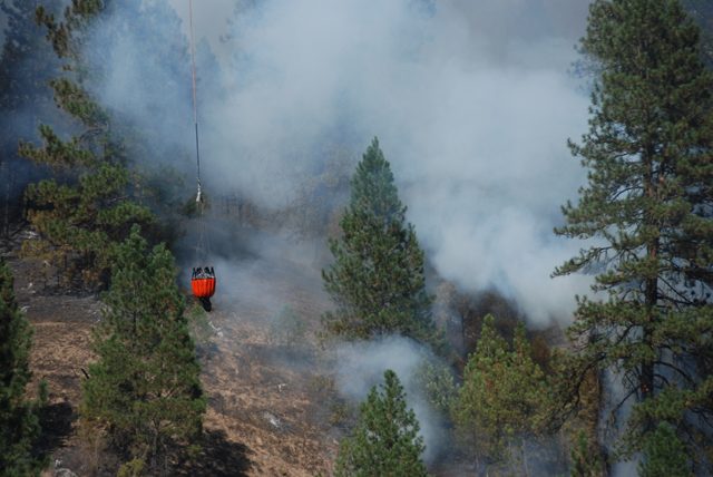
  • This wildfire ignited along Idaho Highway 55 and was started by people. Scientists say as the climate warms, fires like this one will become common place in many parts of the world. (Photo by Sadie Babits)

Climate change has already brought
warmer temperatures, rising sea
levels and melting glaciers. Now,
researchers believe global warming
will cause major shifts in wildfire
patterns around the world. As Sadie
Babits reports, scientists hope to
predict where future wildfires will
light up:

Transcript

Climate change has already brought
warmer temperatures, rising sea
levels and melting glaciers. Now,
researchers believe global warming
will cause major shifts in wildfire
patterns around the world. As Sadie
Babits reports, scientists hope to
predict where future wildfires will
light up:

Trying to predict where wildfires are likely to start decades from now, is
kind of like getting a full body scan.

(sound of medical scanner)

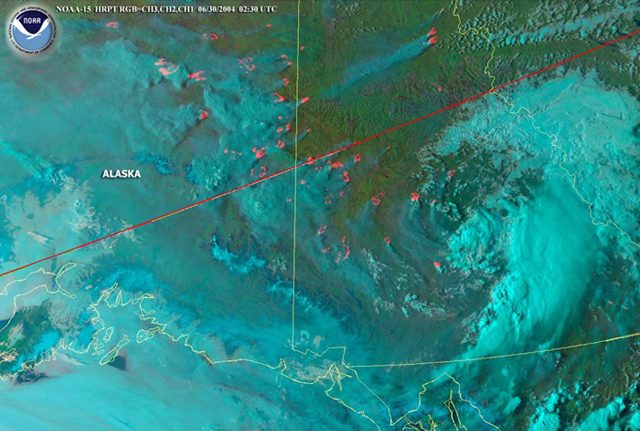
Except instead of a medical scanner, scientists scanned the earth using
satellite data, climate models and the history of present day wildfires to
map out global wildfire patterns.

“The impacts of climate change on wildfires are expected to be widespread
around the world.”

Katherine Hayhoe is a climate scientist at Texas Tech University. She’s part
of a group of scientists that has for the first time, tried to project where fire
hotspots will crop up around the world. She says they found that climate
change will affect wildfire patterns.

Hotter temperatures and rain and snow coming at different times in the
year or perhaps not at all, will mean forests and grasslands will dry out
quicker – becoming tinder boxes for fire.

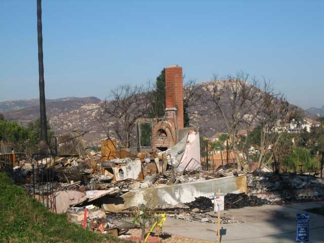
In the next 30 years, scientists believe that the Western U.S. will continue
to see catastrophic fires like the recent blaze in Santa Barbara, which
destroyed 80 homes.

In the next 60 years, they predict wildfires will increase in the Corn Belt and
spread into the East Coast.

Hayhoe says having an idea of how wildfire patterns will shift will help
communities better prepare.

“We can never eliminate the risk of climate change entirely but by making
wise choices and planning strategically we can minimize those risks.”

Some communities are already taking steps to prevent wildfire. The city of
Bend, Oregon was one of the first in the country to launch a public
education campaign to get homeowners to fire proof their homes. The
program, called FireFree, started more than a decade ago, after a massive
wildfire burned nineteen homes and scorched thousands of acres.

“It was something that scarred our community.”

Gary Marshall is the deputy chief of Bend’s Fire Department.

“We have this history of people wanting to live outside the urban area and
live out in rural areas, where they can see the deer and be out in the trees
and live that lifestyle that most Americans who move out to the West want
to be a part of that.”

Bend lies in what’s known as wildfire alley. Every year there are dozens of
fires that crop up either from lightning strikes or from people. The flames
are fed by dried out grasses and forests so dense you can’t see through
them. Add homes to the mix and you have a recipe for disaster not just
here but throughout the West.

But Marshall says the Fire Free program is working.

(sound of a truck driving on a dirt road)

County forester Joe Stutler and Gary Marshall drive me through
neighborhoods outside Bend. We stop first at an upscale suburb called
Coldera Springs. Everyone here has volunteered to fire proof their new
homes.

But just down the road, there’s a much older suburb and a lot of trees that
have been thinned out.

Sadie: “You can’t see through the trees it’s so dense.”

Joe: “You can’t walk through.”

Gary: “And a firefighter won’t go in there. You’d write that off. So if you
don’t take care of it, the fire will.”

That’s a picture that climate scientist Katherine Hayhoe hopes to avoid.
She says having a long term view of where wildfires might pop up could
help communities to start now and follow Bend’s lead.

It took Bend years to get most of the homeowners here to take
responsibility, and give their homes a fighting change to survive a
devastating blaze.

For The Environment Report, I’m Sadie Babits.

Related Links

Climate Change and Wildfires

  • Jennifer Pierce and David Wilkins stand in front of a ponderosa pine forest just outside the city of Boise. They hope to study the relationship between fire and climate here and recreate a snapshot of ancient climate. They are both teach at Boise State University's Geosciences Department. (Photo by Sadie Babits)

Twenty years ago this year, the
country watched its oldest national park
go up in flames. Looking back, scientists
believe the 1988 fires of Yellowstone
National Park were the signal fire of
climate change. Researchers have been
working ever since to understand this
relationship between climate and wildfire.
Sadie Babits reports on two scientists
searching for clues to ancient climates,
using trees as their guide:

Transcript

Twenty years ago this year, the
country watched its oldest national park
go up in flames. Looking back, scientists
believe the 1988 fires of Yellowstone
National Park were the signal fire of
climate change. Researchers have been
working ever since to understand this
relationship between climate and wildfire.
Sadie Babits reports on two scientists
searching for clues to ancient climates,
using trees as their guide:

Jennifer Pierce wears work boots as she plows down a steep slope in a
ponderosa pine forest.

(sound of walking, twigs breaking)

Her blonde hair is tucked up under her Boise State bronco cap, but it keeps
sneaking out. She has to keep brushing it back under. She and her
colleague David Wilkins are professors who work for Boise State
University’s Geosciences Department. They’re in the middle of tall pines in
a forest just outside of Boise, Idaho. Suddenly she’s crashing across the
brambles and heads for this tree.

“Oh that’s a great one! Wow! Sweet!”

She drops to her knees and shows me how this tree has been scarred by
fire.

“You see this little V shaped cat face here at the bottom of the tree that’s
blackened? So during a fire when the bark of the tree gets damaged that
preserves a record of the fire as a scar on the tree.”

Pierce says since the tree has annual growth rings, she can tell when the
tree got burned.

It’s one way Pierce and Wilkins reconstruct the fire history of this forest.
It’s a key to understanding how climate has affected forest fires in the past.

“I think as we move into a likely warmer and drier future, it’s going to be
increasingly important to understand the relationship between climate and
fire.”

She says climate is the primary control for wildfires. As the West warms,
there’s less control. Recently, that’s meant a lot more wildfires.

(popping sound) “There you go!” (sound of a drill bit going through the tree
with sound of birds and forest)

David Wilkins is twisting an auger into the tree.

“It’s a good upper body workout!” (laughs)

It’s a way to take a sample of the rings of this tree. Within a half-minute,
Wilkins’ auger is stuck. The tree is rotten inside. An eight-inch core is all he
gets.

(sound of drill bit coming out of the tree)

Jennifer Pierce takes a look at this sample Wilkins twisted out. The rings –
some light, some dark – reveal just how the tree has responded to moisture
and temperature.

“If you have a tree that kind of is at the edge of its comfort zone so to
speak, it will be more of a sensitive recorder of those environmental
stresses. See this one looks pretty good.”

Tree rings aren’t the only clue these scientists use to reconstruct historic
climates.

(scraping sound)

“I didn’t bring my big shovel. I kind of feel naked without it.”

Pierce scrapes away dirt and she finds bits of charcoal. She can sometimes
use charcoal for radio carbon dating. But these won’t do.

“But, um, I wouldn’t use them for dating because you want to make sure
that the charcoal is stratographicly in place and that you haven’t had
critters burrowing and mixing things up.”

Charcoal can be dated much further back than the tree rings. It helps
Pierce and Wilkins understand what happened here thousands of years
ago. With samples from other scientists, they’ll get a snapshot of ancient
climate and how it affects wildfire.

And possibly determine what climate change will mean for forests in the
future.

For The Environment Report, I’m Sadie Babits.

Related Links

Arctic Summer of Fire and Ice

  • NOAA satellite image, June 30, 2004, showing wildfire smoke blanketing Alaska. (Photo courtesy of NOAA)

The Arctic is melting this summer.
But, that melting is not as severe as it
could be. Lester Graham reports a haze
filters out some of the sun’s rays:

Transcript

The Arctic is melting this summer.
But, that melting is not as severe as it
could be. Lester Graham reports a haze
filters out some of the sun’s rays:

Every year there are forest fires in Alaska, Canada and Siberia. Most of them are
started by lightning strikes. The smoke from the forest can be carried by the winds
across the Arctic. It slows the melting of the ice just a bit.

Bob Stone works with the National Oceanic and Atmospheric Administration.

“It does act as a filter. It extinguishes some of the direct sunlight that would otherwise
impinge on the surface of the snow (and) ice.”

So the smoke shades the arctic from the sun. It’s still not really good news.

Yes, melting slows a bit – but scientists think as global warming continues, we’ll see
more forest fires. That means more of the greenhouse gas CO2 is released, and, fewer
trees soaking up CO2.

For The Environment Report, this is Lester Graham.

Related Links

Costs of Building in Danger Zones

  • In San Diego’s suburbs, the homes on the outer edges of developments and in close proximity to the surrounding countryside are the first to burn. (Photo by Lisa Ann Pinkerton)

During the past 20 years, we’ve been building
homes closer to nature. Whether it’s near coastal areas
or in the wilderness, homebuyers want to live in more
natural settings. But… Lisa Ann Pinkerton reports
often that means putting people and property in the path
of floods or fire:

Transcript

During the past 20 years, we’ve been building
homes closer to nature. Whether it’s near coastal areas
or in the wilderness, homebuyers want to live in more
natural settings. But… Lisa Ann Pinkerton reports
often that means putting people and property in the path
of floods or fire:

2007 was the second worst in history for wildfires in the U.S. Nine-million acres were
scorched and Southern California bore the brunt of it. Most of the property damage was
in San Diego where wildfires in wilderness areas spread to suburban neighborhoods. Half a
million people were evacuated and Shannon Denton was among them. She says her
neighborhood was cleared out at 4 in the morning.

“We were scared. ‘Cause we didn’t – luckily we had all our pictures organized, so we just took most of our pictures and our video stuff, grabbed our kids at the last minute and left within a half-hour. It was scary, very
scary.”

(construction sound)

These days, Denton’s subdivision is busy. There are bulldozers demolishing the burned
out remains of old houses. And construction crews are building new ones on every single
street.

Denton’s thankful her house was spared. But she says even if it had burned down, she’d
take the risk of it happening again, because she likes living here.

“It’s pretty close to nature. There’s a lot of walking and hiking, a lot of mountains that you can take trails and different things.”

Despite the risk of fire, people like Denton don’t want to leave. Some of the 18-
thousand homes lost in San Diego last fall were built in places where wildfires had
burned only four years earlier.

That’s not unusual. The US Fire Administration says nearly 40% of new home
development across the country is in places where residential homes and wilderness meet,
and thus, are more prone to fire.

“They have a right to build that single family home.”

That’s Jeff Murphy of San Diego County’s Department of Planning.

“As a jurisdiction its our responsibility to have codes and ordinances that are
in place to make sure that there’s minimal structural damage as the result of wildfire and minimize
the risk of loss of life.”

Murphy says people are going to live where they want to, all government can do is
require smart development. And San Diego’s building codes are the most restrictive in
the California. They were reevaluated after the 2003 wildfires, when seven percent of the
homes were destroyed.

In the 2007 wildfires, Murphy says the new codes reduced that loss to one-percent.

“Even though we had a lot of structure loss during these fires, what these
numbers are showing us is that our codes are working.”

And Americans aren’t just building in areas at risk of fire. We build in flood zones, too.
FEMA estimates around 10 million people in the US are at risk of flooding. And
according to the United Nations, we saw the most floods of any country last year.

Roger Kennedy is a former director of the National Park Service. He says this kind of
“risky living” costs US taxpayers about two-billion dollars a year in firefighting and
rebuilding costs. The total in property damage hovers around 20 Billion.

Kennedy says people are choosing to build and live on land that’s in danger-prone areas
because they’re not responsible for the true costs. Insurance, guaranteed mortgages, and
federal disaster relief have reduced the personal financial risk.

“People wouldn’t settle in places from which they knew they would not be
rescued and where the taxpayers wouldn’t pick up- or the insurance company which is
essentially the same thing- wouldn’t pick up the tab.”

Kennedy says knowing about a home’s potential risk might reduce the material cost of
fires and floods. And, it might save lives.

But he says, people have to want to know their risks. And even then… they might choose
to ignore it. Because for many, the enjoyment their property brings far outweighs the
occasional “Act of Nature.”

For the Environment Report, I’m Lisa Ann Pinkerton.

Related Links

Gao: Forest Service Lacks Coordination

  • The Government Accountability Office is telling the Forest Service to improve how it deals with the woody material it clears from forests. (Photo courtesy of the USDA)

The government’s effort to reduce wildfires in forests has some
side effects, and a Congressional watchdog agency says the U.S. Forest
Service isn’t doing a very good job of dealing with those side effects.
The Great Lakes Radio Consortium’s Lester Graham reports:

Transcript

The government’s effort to reduce wildfires in forests has some side effects. A Congressional watchdog agency says the U.S. Forest Service isn’t doing a very good job of dealing with the side effects. The Great Lakes Radio Consortium’s Lester Graham reports:


The Forest Service clears out a lot of smaller trees, limbs, and underbrush from forest floors. The idea is to remove what could become fuel for wildfires. Generally, the material is turned into wood chips. The wood chips can be used as fuel or in wood composite products for construction.


The Departments of the Interior and Energy have been working together to try to find new ways to use what the government calls the “woody biomass.” But the Forest Service doesn’t have anyone coordinating with the other agencies.


The Government Accountability Office is calling on the Forest Service to appoint someone to take responsibility for overseeing and coordinating the agency’s “woody biomass activities.” The GAO indicated the material currently has little or no commercial value, but finding new markets for it would be helped if the Forest Service coordinated its efforts with the other agencies.


For the GLRC, this is Lester Graham.

Related Links

Forest Service Needs Better Planting Goals

  • The Government Accountability Office says the U.S. Forest Service isn't providing sufficient data on forest restoration. (Photo courtesy of the U.S. Government Printing Office)

The U.S. Forest Service reports more of the lands it manages are in need of reforestation. But a Congressional watchdog agency says the Forest Service doesn’t keep track of things well enough to know exactly what needs to be done to do the job correctly. The Great Lakes Radio Consortium’s Lester Graham reports:

Transcript

The U.S. Forest Service reports more of the lands it manages
are in need of reforestation. But a Congressional watchdog agency
says the Forest Service doesn’t keep track of things well enough to
know exactly what needs to be done to do the job correctly. The Great
Lakes Radio Consortium’s Lester Graham reports:


For the last five years, the Forest Service has seen a trend. The amount of acreage that needs to be reforested has been increasing. But that’s all it really knows.


The Government Accountability Office says the Forest Service doesn’t have the right data to know how much forest needs to be restored, which sites take priority, or to even estimate a budget. The Forest Service says part of the reason it’s having a hard time figuring out reforestation needs is that it used to calculate reforestation by the amount of trees cut down.


But recently more natural disasters such as wildfires, insect infestations and disease have complicated the calculations. The GAO recommends adjusting Forest Service data collection and policies so that trees can be planted where and when they need to be.


If there’s a delay, the harvested areas become overgrown in scrub brush. And that can cost the Forest Service more money because it has to clear the land before it can be planted in the trees that benefit wildlife and the timber industry.


For the GLRC, this is Lester Graham.

Related Links

Rare Warbler Makes Comeback

  • The Kirtland's Warbler is listed as an endangered species. Its numbers are up these days in Michigan, due to a devastating fire that had positive consequences for warbler habitat. (Photo courtesy of Michigan Department of Natural Resources)

New census figures show the population of one of the rarest songbirds in North America is at a record high. Biologists say the tiny Kirtland’s Warbler is one of the lesser-known success stories of the Endangered Species Act. But the Great Lakes Radio Consortium’s Sally Eisele reports that success has not come without a price:

Transcript

New census figures show the population of one of the rarest songbirds in North America is at a
record high. Biologists say the tiny Kirtland’s Warbler is one of the lesser-known success
stories of the Endangered Species Act. But the Great Lakes Radio Consortium’s Sally
Eisele reports that success has not come without a price:


To find the bird at this time of year, there’s only one place to go—the pine forests of
northern Michigan.


“Hear anything out there yet? No, we may need to take a walk.”


Forest Service biologist Joe Gomola hikes off in search of a Kirtland’s Warbler. He’s
armed with binoculars and a bird watching scope that looks like a bazooka. But he’s
really using his ears.


(forest sounds)


He doesn’t need to go far.


Quietly, he sets up his scope and focuses on a small pine about twenty feet away. There,
a bluish-gray bird—head thrown back, yellow breast puffed out—warbles the loudest
song in the forest.


(Kirtland’s Warbler singing)


“He has to know we’re here… and he just sits unperturbed. Just gorgeous.”


This is the only part of the world where Kirtland’s Warbler are known to nest, drawn to
the scrubby young jack pine that reseed in forest fires.


Logging and fire prevention efforts brought the bird close to extinction. In 1987,
researchers counted only 167 singing males. Ironically, a tragic accident marked a
turning point for the warbler. In 1980, what had begun as a small controlled burn to
create nesting ground for the bird turned into a massive wildfire, killing a Forest Service
worker and engulfing the small village of Mack Lake. But Rex Ennis, head of the
Warbler Recovery Team, says the disaster eventually created 25,000 acres of ideal
warbler habitat. Unexpectedly the bird began to thrive.


“There was loss of life, loss of property which were all tragedies when you looked at
that… but the end result of that was it created an ecological condition we saw the warbler
respond to. Those things we learned from that wildfire made our current management
strategy very successful.”


That strategy involves state and federal agencies working together under the Endangered
Species Act to control predators and create warbler habitat by clear-cutting and
reforestation. The goal is to replicate conditions once created naturally by wildfire.


After the Mack Lake disaster, researchers realized much larger managed habitat areas
were needed. Today, 150,000 acres of state and federal land have been identified as
potential habitat. It’s a massive, multi-million dollar effort and not everybody likes it.


(store ambience)


Linda Gordert and her husband own Northern Sporting Goods in Mio, the heart of
warbler country. She says folks resent the warbler program because it restricts access to
the state and national forests.


“More complaints from hunters and just everybody… when they come in and say you
can’t go into this area because it’s Kirtland Warbler management area. They’re taking up
thousands and thousands of more acres of this because of the Kirtland management area
and that’s the complaints we hear.”


The bird supporters counter the warbler benefits the region. The forestry program
generates jobs and revenue and a yearly Kirtland’s Warbler Festival attracts thousands for
a glimpse of the rare, pretty songbird. But there will always be competition for the land.
And the recovery team says it needs more acreage, not less, to replace habitat as it
matures and becomes unsuitable for the bird.


(Warbler sings)


His scope still on the warbler, Joe Gomola says some worry about the danger of a fire
like the Mack Lake burn, happening again in the flammable jack pine they now plant.


“But it’s part of the ecosystem that was here before us…same with the Kirtland’s and
we’re charged with managing habitat for this endangered species. And that’s what we’re
doing. (SE: “Is that the same bird?”) Same bird. We’re probably close to the center of
his territory, he’s made almost a full circle around us.”


This year’s census found 1,340 singing males—a record that has started talk of eventually
changing the warbler’s endangered status. But the recovery program has become the
bird’s life support system. 90 percent of the birds were counted in man-made plantations,
indicating habitat management must also continue indefinitely if the bird is to survive.


For the Great Lakes Radio Consortium, I’m Sally Eisele.

Related Links

Aerial Firefighting

High-risk fire conditions are expected to continue for another fewweeks across the Midwest. Firefighting crews are on standby, hoping toprotect not only forests, but also the fast-growing number of homes andcabins. In Wisconsin, they’re trying a new tool they hope will keepfires under control. The Great Lakes Radio Consortium’s Mike Simonsonreports: