The International Joint Commission will be studying water levels to find out why Lake Michigan (pictured) and the other upper Great Lakes have been lower. (Photo by Lester Graham)
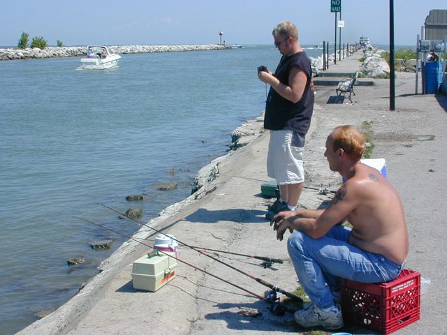
If Great Lakes levels continue to decline, docks and marinas might be forced to dredge or relocate to stay open to boaters. (Photo by Lester Graham)
The IJC will try to determine how much climate change and the engineering of the channels between the lakes are affecting the water levels in the Great Lakes. (Photo by Lester Graham)
A five year, 15 million dollar study will look at water levels of the Great Lakes.
Chuck Quirmbach reports on some of the concerns:
Transcript
A five year, 15 million dollar study will look at water levels of the
Great Lakes. Chuck Quirmbach reports:
Since 1911, the U.S.-Canadian International Joint Commission, or IJC, has
regulated how much water flows out of Lake Superior and eventually into
the rest of the Great Lakes.
Currently, Lake Superior is near its record low level, and Lakes
Michigan and Huron are relatively low. That’s triggering several
problems, including forcing many ships to carry less cargo.
The IJC study will look into the potential reasons for the water level
changes. Study co-chair Eugene Stakhiv says it might not be a simple
matter:
“It’s a whole series of issues that we’re going to have to untangle and
then sort of resolve almost independently and then put the puzzle back
together again.”
Stakhiv says the study will look at big-picture topics, like the role
of climate change and how the channels between the lakes are
engineered.
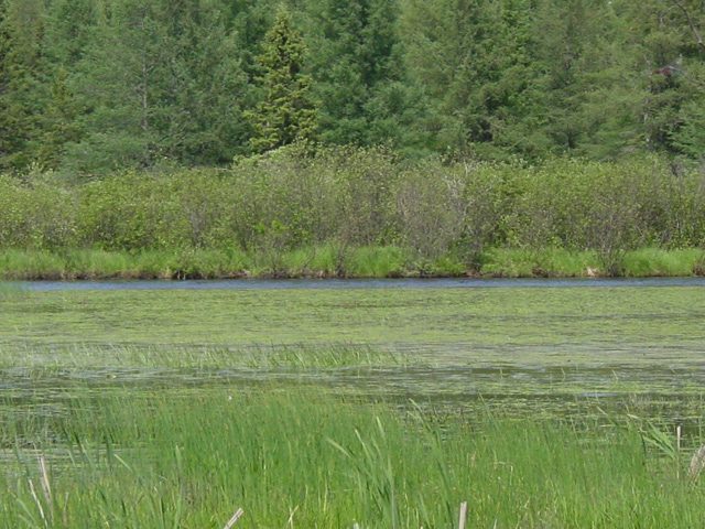
Roger LaBine winnows the wild rice. (Photo by Michael Loukinen, Up North Films)
The Ojibwe tribe harvest rice on Lac Vieux Desert, but doing so can lower water levels and create muddy shorelines. (Photo by Michael Loukinen, Up North Films)
Since European settlers first came to this country they have had serious conflicts with Native Americans. The GLRC’s Sandy Hausman reports on one modern-day dispute between a Native American tribe and communities in the upper Midwest:
Transcript
Since European settlers first came to this country they have had serious conflicts with
Native Americans. The GLRC’s Sandy Hausman reports on one modern-day dispute
between a Native American tribe and communities in the upper Midwest:
(Sound of Ojibwe music)
The Ojibwe tribe first came to the north woods of Michigan and Wisconsin hundreds of
years ago. They say their migration from the east coast was guided by prophets. Those
prophets told them to keep moving until they came to a place where food grows on the
water. Roger Labine is a spiritual leader with the tribe. He says that food was wild rice:
“This was a gift to us. This is something that is very, very sacred to us. This is very
important, just as our language. This is part of who we are.”
For hundreds of years, wild rice was a staple of the tribe’s diet, but starting in the 1930s,
private construction of hydroelectric dams pushed water levels in rice growing areas up.
High water killed most of the plants and took a toll on wildlife. Bob Evans is a biologist
with the U.S. Forest Service. He says fish, bird and insect populations dropped
dramatically:
“Black tern is a declining, threatened species that is known to use wild rice beds,
Trumpeter swans. They’re a big user of rice beds. Um, just a whole lot of plants and
animals. It’s really a whole ecosystem in itself.”
So in 1995, the tribe, the U.S. Forest Service and several other government agencies
demanded a change. A year later, the federal government ordered dam operators to drop
their maximum water levels by 9 inches. The dam owners appealed that decision, but in
2001 a federal court ruled against them.
That fall, the Ojibwe who live on Lac Vieux
Desert harvested nearly 16 acres of wild rice and this summer, the tribe is tending more than 55 acres.
But the resurgence of rice beds comes at a price. Lower lake levels have left docks in this
boating community high and dry, created muddy shorelines and made long-time residents
and summer boaters angry:
“I used to come here and dock all the time. We picnicked here. I had to walk in 50 feet,
because there wasn’t enough water to float a pontoon, and it’s that way all around the
lake.”
Ken Lacount is president of the Lac Vieux Desert homeowners association. He first
came here in the 1940s and doesn’t see why his cultural traditions should take a backseat
to those of the Ojibwe:
“My grandfather built one of the first resorts. I fished in Rice Bay my entire life. That
was his favorite place to take me.”
Lacount is bitter. He and his neighbors feel powerless to change the situation, since a
federal court has ruled for the Ojibwa. Defenders of that decision say water levels are
especially low because of a prolonged drought in region. When that ends, they predict
lake levels will rise, and homeowners on Lac Vieux Desert will be happier.
(Sound of paddling)
Such conflicts are nothing new. Ron Seeley is a reporter for the Wisconsin State Journal. He’s covered Native American issues for more than 20 years. Paddling through the rice beds, he recalls an earlier battle
over fishing rights. In the late 80s, a court ruled the Ojibwe were entitled by treaty to
spear fish each spring. Local fishermen worried the practice would destroy their industry:
“Sometimes thousands of people would show up at the landings on a spring night. Tribal
members from all over the upper Midwest would come to support the spearers and drum
and chant. The anti-Indian forces were arrested for using wrist rockets or real powerful
sling shots to shoot pellets at the tribal members while they were out spearing. It was a
violent time up here.”
As court after court upheld the rights of native spear fishermen, and as commercial
fishermen continue to prosper, hostilities subsided and now, as the Native Americans prepare for
their biggest rice harvest in more than 50 years, the Ojibwe hope that the controversy over water levels
will also die down. Tribal leader Roger Labine says wild rice is a symbol of the Ojibwe’s survival:
“This is an endangered species. It’s something that we’re fighting to save, just like the
eagle, just like the wolf. We were put here to care for Mother Earth and all the gifts that
the creator gave us.”
And having won the first battle to restore rice beds, Labine is hoping to secure even
greater protection for these wetlands by asking the federal government to declare the rice
beds historic.
A new study predicts that water levels in the Great Lakes could drop significantly over the next 50 years. The Great Lakes Radio Consortium’s Karen Kelly reports:
Transcript
A new study predicts that water levels in the Great Lakes could drop significantly over
the next 50 years. The Great Lakes Radio Consortium’s Karen Kelly reports:
Researchers at Environment Canada say global warming could cause shorelines to drop
by more than three feet over the next five decades. The findings were based on computer
models, which are predicting hotter and drier conditions in the region’s future. David Fay
is coauthor of the study. He says a drop in water levels would affect many people,
starting with landowners.
“If they have a dock on their property, the water depth of the dock would go down. It
would certainly impact commercial navigation… quite significant environmental changes
are possible.”
Fay says the study offers predictions, not guarantees. But it does suggest that Lakes
Michigan and Huron and the St. Lawrence River would be most affected.
For the Great Lakes Radio Consortium, I’m Karen Kelly.
Even though it’s been a rainy summer, the shipping industry, boaters and beachgoers are still dealing with low water levels on the Great Lakes. The Great Lakes Radio Consortium’s Rebecca Williams reports:
Transcript
Even though it’s been a rainy summer, the shipping industry, boaters and beachgoers
are still
dealing with low water levels on the Great Lakes. The Great Lakes Radio
Consortium’s Rebecca
Williams reports:
All the rain this season has raised hope for an end to low water levels. But Lakes
Michigan,
Huron and Superior continue to be much lower than average for the fourth year in a row.
Frank Quinn is a hydrologist with the National Oceanic and Atmospheric
Administration. He
says rain is not the only factor affecting lake levels. Temperatures and
evaporation also affect
them. Quinn says the recent rain has helped, but more rain is needed.
“We’ve averaged for the last year about 90% of our normal precipitation…we still
haven’t had
enough continuing rainfall to bring the levels back up to what their long-term
averages would
be.”
Rain has helped raise the lower lakes, Ontario and Erie, but NOAA’s 6-month outlook
shows low
levels continuing on the upper lakes through early spring.
For the Great Lakes Radio Consortium, I’m Rebecca Williams.
The fight between environmental and business interests on the Missouri River has created legal wrangling in two federal courts. The Great Lakes Radio Consortium’s Tom Weber reports:
Transcript
The fight between environmental and business interests on the Missouri
River
has created legal wrangling in two federal courts. The Great Lakes
Radio Consortium’s
Tom Weber reports:
The controversy started when a federal judge in Washington recently
ordered
the U.S. Corps of Engineers to lower water levels on the Missouri
river.
That move would protect endangered birds and fish that risked losing
their
nests with the higher water levels.
The Corps told the judge, though, it intended to ignore that ruling
because of a
previous ruling in a Nebraska court. That ruling said water levels
should
be high enough to keep barge traffic moving on the lower Missouri.
The Washington judge scolded the Corps for refusing her order and ruled
the
agency in contempt. The Corps in turn asked the Nebraska judge to
modify
her ruling to allow it to avoid heavy fines for being in contempt.
But Wednesday… the Nebraska judge refused. The Corps is appealing
her
ruling.
For the Great Lakes Radio Consortium, I’m Tom Weber.
The soggy spring has helped raise water levels in the Great Lakes. Lake Ontario is above average, but the upper lakes could still use more rain. The Great Lakes Radio Consortium’s David Sommerstein explains:
Transcript
The soggy spring and summer so far has helped raise water levels in the
Great Lakes. Lake Ontario is above average, but the upper lakes could still
use more rain. The Great Lakes Radio Consortium’s David Sommerstein
reports.
A few years of drastically low water levels have stranded boats and docks
and forced shippers to light their loads throughout the Great Lakes, but
Chuck O’Neill, of New York Sea Grant, says spring rains have come to the
rescue. Precipitation was 30% higher than normal in May region wide, 60%
higher than normal in Lakes Erie and Ontario:
“And when you put that much water into a basin that responds quickly like
the Lake Ontario basin, that’s reflected in the lake level quite dramatically.”
Lake Ontario is up more than 30 inches from March and is now four inches
above average. O’Neill says the rain has helped the upper lakes some, but
they’re still low, especially Lake Superior.
“That is such a huge lake even when they do have above average
precipitation, it takes an awful lot more above average precipitation to
push that lake up anything significantly.”
The rise and fall of the lakes is natural over time, but many experts worry
climate change is lowering the watermark for the long term.
For the Great Lakes Radio Consortium, I’m David Sommerstein.
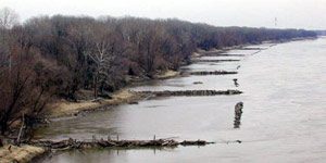
The Army Corps of Engineers installed these wing dams to force the current to the middle. The rushing water scours the bottom of the channel to keep navigation open. A new study alleges the wing dams slow the current during major floods and cause flood waters to be higher. Photo by Lester Graham.
A recent study concludes that some actions of the Army Corps of Engineers might be causing more, rather than less damage during major floods on rivers in the Midwest. The study by two Washington University professors found that wing dams, which jut out into the river, could cause big floods to rise even higher. The Great Lakes Radio Consortium’s Lester Graham takes a closer look at this study:
Transcript
A recent study concludes that some actions of the Army Corps of Engineers might be causing more, rather than less damage during major floods on rivers in the Midwest. The study by two Washington University professors found that wing dams which jut out into the river could cause big floods to rise even higher. The Great Lakes Radio Consortium’s Lester Graham takes a closer look at this study:
The Mississippi and the Missouri rivers are two of the major arteries for barge transportation in America. Millions of tons of grain, and raw materials are floated up and down the rivers each year. It’s the Army Corps of Engineers’ job to keep the rivers open to barge traffic. The Corps has been doing that job for the past 150 years. But since the 1930’s that effort has taken on immense proportions. Huge dams hold back the river, keeping the water high enough for the barges to travel up and down-stream. Big earthen dikes, called levees, wall in the rivers, keeping them from flooding farms and towns, but also keeping the water from reaching the natural flood plain. Robert Criss and Everett Shock studied flood levels and the effects of the Corps of Engineers projects. Criss says those dams and levees alone might be enough to disrupt the flow of the river and cause flood stages to be higher.
“But the other component is these structures called wing-dams which are jetties of rocks that project out perpendicularly into the channel. For high-flow conditions, these act something like scale in a pipe. They impede the flow, restricting the channel. That slows the velocity of the water down and that also makes the flood stages higher.”
The purpose of wing dams is to force the current to the middle of the river to scour out the navigation channel to keep it open for the barges. Researcher Everett Shock.
“So, they do the job they’re intended to do. It seems that there’s an unintended–perhaps unintended consequence of all these constructions along the river that shows up when we have a big flood and makes it to –on the basis of our study– makes these big floods worse.”
Criss and Shock say their study finds that since these flood control projects have been erected, there have been more big floods, such as the one in 1993 that flooded the Mississippi and some of its tributaries for most of the summer. Robert Criss.
“The fact is, before World War II, a flood stage of 38-feet is very rare and now it happens every five years.”
But not everyone agrees with the methodology used by the researchers. The
Corps of Engineers dismisses the researchers’ study, saying they used flawed data. Corps officials point to a study at the University of Missouri – Rolla. That study compared the 19th century method of measuring a river’s flow by timing how fast floats moved in the current to the methods used today. Dave Busse is a scientist with the Army Corps of Engineers. He says the original stream flow measurements –the ones Criss and Shock used— were inaccurate.
“The flows were over-estimated by 30-percent using this float measurements rather than the measurements than we use today.”
Criss and Shock are skeptical of new numbers that the Corps prefers. Saying it seems awfully convenient for the Corps because changing the numbers makes the historic floods look smaller and therefore makes the 1993 flood look unprecedented. Criss and Shock say based on the original records, there was as much water in past floods as in the 1993 flood but lower water levels. Criss and Shock say the difference between then and now is that the Corps’ big dams, levees, and wing dams constrict the river’s flow and make floods higher.
The Corps, however, has other criticisms of the Criss and Shock study. Dave Busse says the researchers ignored the role of the Corps’ reservoirs in the rivers’ watersheds. Busse says the reservoirs hold back water that would otherwise be part of a flood. And Busse says, another flaw is the researchers conclusions about wing dams. The Corps says the wing dams force water to deepen the channel and increases the flow of the river.
“So, what we have is the same –it’s a re-shaped river, but its carrying capacity is actually higher now. We can actually carry more water at the same stage. The river got deeper, therefore this conclusion that they’ve made is wrong.”
The Corps says there’s more to managing the river than the researchers have considered. Criss and Schock, meanwhile, say their study is not the first to be dismissed by the Corps of Engineers. They say other studies have found similar results, but the Corps dismissed them as well.
Environmentalists have been arguing for decades that levees and dams keep floodwaters from spreading out on their natural flood plains and cause higher flood levels. The Criss and Shock study adds to their arsenal of arguments to change the way the rivers are managed. But most environmentalists concede that we’ve become somewhat dependent on the Corps flood control projects. Chad Smith is with the environmental group,
American Rivers.
“In most ways both of these camps are right. The Corps is right that putting some of the structure in has helped to reduce the kind of annual flood events that always happen on a big river like this, but what they unfortunately have done is to exacerbate what happens when you have bigger floods and the wing dams and the levees and the dams themselves all are part of that.”
The Army Corps of Engineers says it’s reviewing its way of managing rivers in light of the 1993 flood. But they also note that while flood stages might be higher more often than they were in the 19th century, most of the time those floodwaters remain behind the floodwalls and levees, protecting the communities from high water, and the Corps says in the end, that’s the only fact that really matters.
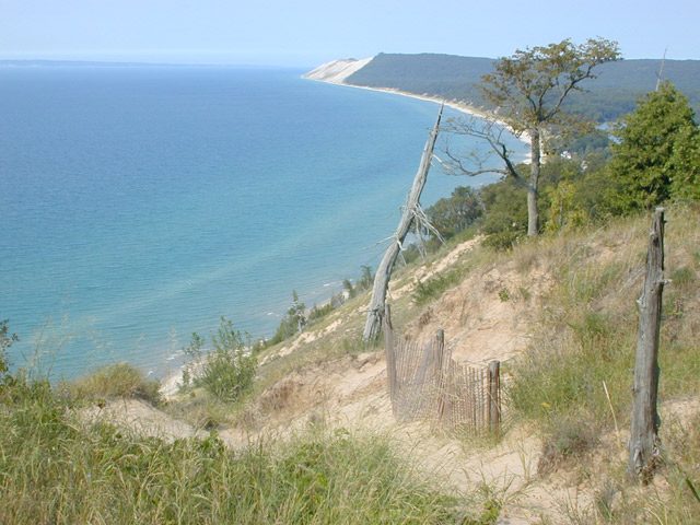 The International Joint Commission will be studying water levels to find out why Lake Michigan (pictured) and the other upper Great Lakes have been lower. (Photo by Lester Graham)