Interview: From the Pacific Garbage Patch

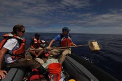
  • Researchers with Project Kaisei are studying a swirling vortex of trash that has accumulated out in the Pacific Ocean. (Photo by Annie Crawley, courtesy of Project Kaisei)

A huge current rotates in the Pacific Ocean, causing floating plastic trash to gather in a giant vortex of garbage in the middle of the ocean – it’s become the world’s biggest dump. Project Kaisei has sent two ships to the area to study the problem. Doug Woodring is on the New Horizon. He talked with Lester Graham by satellite phone:

Transcript

A huge current rotates in the Pacific Ocean, causing floating plastic trash to gather in a giant vortex of garbage in the middle of the ocean – it’s become the world’s biggest dump. Project Kaisei has sent two ships to the area to study the problem. Doug Woodring is on the New Horizon. He talked with Lester Graham by satellite phone:

Lester Graham: You’re in the middle of the Pacific right now, looking for the Great Pacific Garbage patch. How much luck have you had in locating some of this plastic debris?

Doug Woodring: Unfortunately, too much luck. (laughs) It hasn’t been very difficult. In fact, I’m running into, ah, I can look out the window and see a big floating piece, right now, as we’re going by. But we’ve been, the last 5-6 days, we’ve been in it consistently. It’s not as many big pieces as the world might think, but it’s way many more small pieces than people know. And the reason is, with the UV dedrigation in the plastics, it get very brittle when it’s broken down by the sun, so after some time in the water, when the wave action, it’s very easy for everything to break down and sort of crack. So what we’re getting is what they call ‘confetti’, and it’s just literally in some places many, many pieces per square meter of this stuff. And we are really looking mostly at the surface, so it’s not known yet how deep this is either. So, there’s a lot of stuff out here.

Graham: Why’s this bad for the environment?

Woodring: When you get small pieces, you’ve got mistaken potential food source for animals. So, the marine life can be eating this. It is possible that it gets in the food chain. There are toxins, heavy metals, and persistent organic pollutants that attach themselves to plastics when they float. So, it’s not just a piece of plastic that a marine life eats, it’s a polluted piece of plastic. It’s also a little island, or a little flotation for species that can float around the ocean – and invasive species can go to different parts of the waters or land that wouldn’t have traveled that way otherwise. So, there’s a lot of implications that this science is only just now starting to help us figure out what’s going on.

Graham: Does anybody have any idea what we can do to reduce the impact of this huge garbage patch or to clean it up?

Woodring: Well, this is what we’re out here for. That’s the main part of our mission is to find solutions. And we can’t find solutions until we have some of the answers, and some of the data. So what we’re out here is with two vessels now, over a 30 day period, really looking for that data – water depth, leadings and temperatures and flows and salinity – to see how the plastics and the material, the debris might move around in the ocean. We will, later, be doing some analysis on the material, science of the plastics, to see if it’s recognizable by satellite. Because, obviously, without satellite imagery, it’s impossible to know exactly where the bigger masses are. You know, ‘how to clean it up,’ is going to be a very tricky thing, because the oceans are so big and these particles are not big. It’s all going to come back to what we’re doing on land, really, and the land policies for different ways to bring in better recycling and rebate programs to get a lot of the plastic that is out there today to be reused instead of simply thrown away, and so it doesn’t get into the rivers or the oceans in the first place.

Doug Woodring is a co-founder of Project Kaisei. He spoke with The Environment Report’s Lester Graham.

Related Links

Sea Levels Threaten Coastal Towns (Part One)

  • The boardwalk in Ocean City, Maryland. Before beach replenishment, you could get your feet wet standing underneath the boardwalk. Now, as you can see, the water is 200 feet away. (Photo by Tamara Keith)

It’s beach weather – and along the mid-Atlantic one of the most popular beaches is Ocean
City, Maryland. For years, engineers have been battling back the ocean to save the beach
and the town. And as Tamara Keith reports, that fight is only going to get tougher and
more expensive if predictions of sea level rise from climate change become a reality:

Transcript

It’s beach weather – and along the mid-Atlantic one of the most popular beaches is Ocean
City, Maryland. For years, engineers have been battling back the ocean to save the beach
and the town. And as Tamara Keith reports, that fight is only going to get tougher and
more expensive if predictions of sea level rise from climate change become a reality:

When the sea level rises, Ocean City feels it. It’s on the front lines – a barrier island on
the edge of the Atlantic.

(sounds of water)

Terry McGean is the city engineer for a town he describes as a working class resort.

“Our industry is tourism, and the real reason people come here is the beach.”

But in the 1980s, that beach was reduced to a narrow strip. Not so today, all thanks to a
massive, and expensive, beach replenishment project. In 1991 countless tons of sand
were brought in, dunes were built. But that wasn’t the end of it.

To keep up with erosion, McGean says the beach here at Ocean City has already been re-
nourished 4 times.

“Approximately every 4 years we’re doing a re-nourishment project. To give you an idea
of the scale, that’s 100,000 truck loads of material that we’ll put on here. Though it
doesn’t actually come on a truck? No. It’s pumped in a dredge from out in the ocean.”

It is a constant fight, because the waves keep coming, keep pulling the sand back out to
sea. Scientists say this is partially just normal erosion. But some of it at least can be
blamed on global climate change and sea level rise. Over time, they say, the share of the
problem caused by climate change will grow.

“If you hadn’t done the beach replenishment do you have any sense of what this would
look like right now. There probably would have been no public beach left in many of
these areas.”

So far fending off the sea has cost $90-million, split amongst local, state and federal tax
dollars. But engineers estimate some $240-million in storm damage has been prevented.

“Holding back the sea is an economic proposition. If you’re willing to spend the money,
the sand exists to elevate any given barrier island.”

Jim Titus is the project manager for sea level rise at the Environmental Protection
Agency. And he’s been sounding the alarm about climate change for years. And he says
policy makers and the public will eventually have to decide which beaches, which
communities are worth saving.

“The challenge for communities like Ocean City is to persuade everyone else that they
are one of those cities that are too important to give up. And then to get their residents to
cooperate in doing what it takes to do to gradually elevate the entire community with a
rising sea.”

But if you think in geologic time, like University of Maryland professor Michael Kearney
does, there isn’t a whole lot of hope for barrier islands like Ocean City.

“It’s essentially a pile of sand. There’s really nothing permanent about it.”

Kearney studies coastal processes.

“The long term prospect of any barrier surviving the projected rates of sea level rise, even
at the moderate rates – the so-called moderate rates, that the IPCC predicted is pretty
slim.”

Ocean City engineer Terry McGean just isn’t buying it. He thinks Ocean City can survive
sea level rise.

“I think that we can design towards it and we can probably build towards it and with
responsible actions we can live with it.”

As long as there’s enough sand and money to keep it going.

For The Environment Report, I’m Tamara Keith.

Related Links

Sea Levels Threaten Coastal Towns (Part Two)

  • A living shoreline near the Chesapeake Bay in Maryland. The native grasses and sandy shore provide habitat for terrapins, the University of Maryland mascot. (Photo by Tamara Keith)

Scientists are pretty certain climate change is going to cause the sea level to rise. It’s
happening already, actually. In communities around the Chesapeake Bay, people are
getting a sneak preview. Tamara Keith reports some people there are trying to work with
nature rather than resist it:

Transcript

Scientists are pretty certain climate change is going to cause the sea level to rise. It’s
happening already, actually. In communities around the Chesapeake Bay, people are
getting a sneak preview. Tamara Keith reports some people there are trying to work with
nature rather than resist it:

(sound of kids planting)

It’s been raining in Woodland Beach. The community is just off of the Chesapeake Bay
in Maryland. The ground here is so soft you sink into it. Mud is everywhere. And that’s
just fine with the volunteers planting native grasses on a sloping hillside.

Stephen Hult is trying to keep things in order.

“And when we plant them we want them all the way down. I’m telling everyone twice.”

Hult heads up shoreline restoration projects for the local property owners association.
And there’s a lot of shoreline to restore.

“The shoreline, in parts of the community since the 1930s, have eroded 20 feet. Year to
year, one barely notices, but if you look at aerial maps of what it used to be like
compared to what it is, it really is quite dramatic.”

There’s been tons of erosion here. The land all along the mid-Atlantic coast is also
slowly sinking. Combine that with global sea level rise and you get erosion in overdrive.

Hult says the community is trying to restore the beach with rock and dirt and sand and
grasses to hold it all together. This is what’s called a living shoreline.

“We have now, with this project it will be well over half a mile of living shorelines that
we’ve installed.”

It’s a relatively new concept, a more natural approach to the gnawing problem of
shoreline erosion. Living shorelines create buffer between the water and homes. They are
kinda like the tidal wetlands that used to be here – before property owners started building
sea walls, also called bulkheads.

Jana Davis is associate director of the Chesapeake Bay Trust. It’s one of the organizations
funding this shoreline restoration. And Davis also happens to live here.

“It’s a wonderful alternative that provides just as good shoreline protection while also
providing a lot of really important habitat benefits that a bulkhead or rock sea wall does
not provide.”

Good for wildlife, and she says, it’s adaptive in the face of sea level rise.

“If sea level were to rise another foot, for example. The marsh could kind of migrate
inland, whereas if you had a bulkhead obviously there’s no migration because it can’t
move.”

But most of the people with bulkheads are NOT buying it. They want to protect their
property from the sinking land and rising water, and a lot of them don’t think a bunch of
rocks and grass are going to cut it.

Kevin Smith is chief of restoration services for the Maryland Department of Natural
Resources.

“There’s many places you can go and look at miles of shoreline and not see any natural
shoreline at all. It’s all armored off.”

Smith met me at a nature center along the bay. A few years ago, a stretch of bulkhead
here was replaced with a living shoreline. The natural ebb and flow of these shorelines
has made some property owners skeptical. They want the shoreline to stay put.

“If these types of projects don’t protect that shoreline from erosion, then homeowners are
not going to want to do it.”

But Smith insists these projects do work, and long term they’re going to be more
sustainable and more flexible than bulkheads – which over time will lose the battle
against the constant pounding of the rising sea.

For The Environment Report, I’m Tamara Keith.

Related Links

Scientists Keep Tabs on Exotic Crab

  • Sightings of the Chinese mitten crab outside of its native habitat make some scientists uneasy that it will turn into an invasive species. (Photo courtesy of the California Department of Fish and Game)

Biologists are asking people to keep their eyes peeled for another potential invader into the Great Lakes. A Chinese mitten crab was found in the St. Lawrence River last fall. The Great Lakes Radio Consortium’s David Sommerstein reports:

Transcript

Biologists are asking people to keep their eyes peeled for
another potential invader into the Great Lakes. A Chinese mitten
crab was found in the St. Lawrence River last fall. The Great Lakes
Radio Consortium’s David Sommerstein reports:


Scientists aren’t sounding the alarm yet. One Chinese mitten crab found near Quebec City doesn’t constitute an invasion. But if they reproduce, the critters could spread quickly.


David MacNeill is a fisheries specialist with New York Sea Grant. He says one was found in Lake Erie in the 1970s, but didn’t proliferate. The mitten crabs spawn in salt water, so they don’t really threaten the upper Great Lakes. But the St. Lawrence River may be better habitat. Regardless, MacNeill says the discovery highlights problems with foreign ships exchanging ballast water before they enter the Great Lakes system.


“Inside ballast tanks on ships, they’re like giant tidal mud flats. When you empty all the water out, there’s this large mud layer. Some of these organisms can burrow into the sediment which is what the mitten crabs do.”


In January, the Coast Guard conceded its ballast discharge rules don’t always work. It said it must find new ways to keep foreign invaders out of the Great Lakes.


For the Great Lakes Radio Consortium, I’m David Sommerstein.

Related Links