The Costs of Preventing Flood Damage

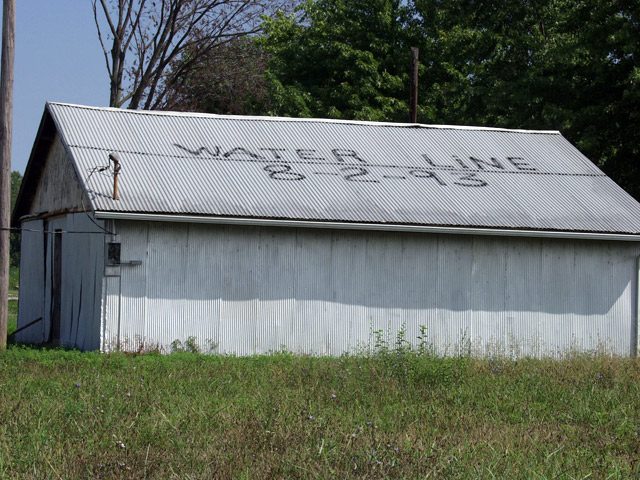
  • A shed in Valmeyer, Ill. shows how high the water got during the 1993 Flood. The flood waters caused such damage that most of the town moved a few miles east, high up on a bluff. A few residents and many farmers, though, stayed in the flood plain. (Photo by Tom Weber)

It’s been 13 years since the Great Flood of ’93 caused widespread destruction along the upper Mississippi River. After the flood, there was talk of needing to expand the natural floodplain by eliminating levees that protect farmland. That didn’t happen. In fact, not much of anything has happened, but that doesn’t stop farmers from wondering if the government will buy their farms and turn them into natural areas designed to take the waters of the next big flood. Tom Weber reports:

Transcript

It’s been 13 years since the Great Flood of ’93 caused widespread destruction along the
upper Mississippi Rivers. After the flood, there was talk of needing to expand the natural
flood plain by eliminating levees that protect farmland. That didn’t happen. In fact, not
much of anything has happened, but that doesn’t stop farmers from wondering if the
government will buy their farms and turn them into natural areas designed to take the
waters of the next big flood. Tom Weber reports:


For all the river talk in these parts, it’s actually kind of hard to see the water. Doug
Sondag’s farm is about about two miles from the river and his view to the west
is of the bluffs, on which Missouri towns, like Herculanium, sit.


“That’s Missouri bluffs. That’s Missouri bluffs, and to the north the bluffs that you see is Missouri.
We’re on a big bend here.”


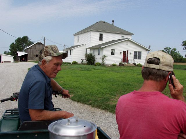
Doug’s friend Ron Kuergeleis is visiting the farm today. Kuergeleis lost his home in the
’93 flood, but he still farms on the flood plain near Valmeyer, Illinois. The two also are
commissioners with the local levee district, which means they’re in charge of keeping the
local levee up-to-date so the river is kept away.


Today, though, they’re talking about the possibility of a new federal levee and something
called “Plan G.”


(Ron): “You’re talking quite a few farmers that would absolutely put them out of
business. You’re one of them, I’m one of them, and there’s – (Doug): “There are quite a few
more.” (Ron): “There are quite a few more.”


No one is going out of business any time soon, though. Plan G is something the Army
Corps of Engineers studied and decided wasn’t worth the money. It would have the
Corps spend billions building up bigger levees along the upper Mississippi to 500-year
levees: the highest levees the Corps builds.


Plan G also would create a huge storage district nearby. A storage district is a kind of
relief area where flood waters go to take strain off other levees. Corps engineer Richard
Astrack says design elements like these can help control flooding in other places:


“Now we have the capability that we didn’t have before to look at whole system to ensure
that actions taken at one location can impact another location.”


The Valmeyer storage district would require a new levee in the flood plain, which would
leave 10,000 acres of currently protected farmland unprotected and on the wrong side of
the levee.


This all started a few years ago, when Congress told the Corps to study the entire Upper
Mississippi River, from Illinois’s southern tip to Minnesota, find out if the current levees
are good enough to reduce flood damage. If not, should there be some comprehensive plan to guide just which levees get built up and when? Such a study actually had never been done.


The Corps’ Richard Astrack says they looked at a lot of options, including that Plan G,
to see if any of them were worth the time and money. And it turns out, none of them is:


“None of the plans passed that test. Our draft report does not
recommend any systemic plan.”


And the Corps’s final report will probably recommend essentially doing nothing because
the current system does a good enough job of preventing flood damage. The Corps will
recommend updating, but not raising, current aging levees, and also creating some mini-
levees to protect roads that approach bridges.


But even with all the assurances that Valmeyer, Illinois is safe for now, farmers in the
bottomlands are worried that the federal government might one day force their children
or their grandchildren off their farms.


Ron Kuergeleis is a fourth generation farmer:


“We’re pretty much assured in our lifetime it ain’t gonna happen. But some of us got another
generation coming up and you don’t know. He claims, you know where you going to
come up with money, but if they want to come up with it, they’ll find it.”


The worries stem from the fact that Corps cannot, in all fairness, guarantee that such a
levee would never be built. Because setting aside some of the bottom lands for natural
flooding could protect big cities such as St. Louis, Missouri and Memphis, Tennessee,
there’s concern that Congress might one day instruct the Corps of Engineers to buy out
those farms.


So, while Valmeyer is not getting a new levee right now, the people here say they’ll keep
working to stay one step ahead to make sure it never happens.


For the Environment Report, I’m Tom Weber

Related Links

Groups Work to Restore American Elm

  • The American Elm was devastated by Dutch elm disease. (Photo courtesy of VA Department of Forestry)

The American elm was found throughout forests in the Midwest before Dutch elm disease took hold. The disease cut the population of elms by more than half. Now, the U.S. Forest Service wants to re-establish the stately tree. The Great Lakes Radio Consortium’s Sandra Harris reports:

Transcript

The American Elm was found throughout forests in the Midwest before Dutch elm disease took hold. The disease cut the population of elms by more than half. Now, the U.S. Forest Service wants to reestablish the American Elm. The Great Lakes Radio Consortium’s Sandra Harris reports.


The Forest Service is working with the U.S. Army Corps of Engineers on a small tree-planting project along the Mississippi River. Randy Urich is a natural resources officer with the Corps. He says it’s one of several similar projects aimed at brining back American Elms.


The trees were once a major part of flood plain forests. Urich says the tree was lost to Dutch elm disease beginning in the 1930’s.


“One of the characteristics of elm is that it’s very tolerant of shade, and in these floodplain forests you have a tendency to get some very dense overstory canopy, and because of that shade tolerance, the elms are really good at regenerating themselves.”


Researchers are developing disease-resistant American Elms by using various cloning techniques, including cloning trees that have naturally survived the disease.


For the GLRC, I’m Sandra Harris.

Related Links

Charting a Course for the ‘Big Muddy’

  • A recent National Academy of Sciences report on the Missouri River suggested some of the river's natural meanders and access to the flood plain be restored. It also suggested sections of the river be reviewed to see if barge traffic might be closed for parts of the year or permanently.

The National Academy of Sciences has issued a report that calls for the restoration of the longest river in the United States. That report says the government needs to stop studying problems along the Missouri River and – with the help of residents – do something about them. The Great Lakes Radio Consortium’s Lester Graham has the story:

Transcript

The National Academy of Sciences has issued a report that calls for the restoration of the longest river in the United States. That report says the government needs to stop studying problems along the Missouri River and – with the help of residents – do something about them. The Great Lakes Radio Consortium’s Lester Graham reports:

On the opposite bank from here, you can see the Big Muddy empty into the Mississippi River. I’m standing on the spot where Lewis and Clark and the Corps of Discovery spent the winter before starting their historic expedition up the Missouri, across the Rockies and to the Pacific coast. If Lewis and Clark could see the Missouri today, there’s little that they’d recognize at this end of the river. Over the years it’s been straightened, walled-in by levees and channelized. Its braided river system of meanders, backwaters and eddies, once alive with wildlife are – for the most part – gone.

Seventy years ago as the government began huge civil engineering projects; it expected the Missouri River to be a major transportation means of getting grain from the farm fields of Nebraska, Kansas, Iowa and Missouri to the markets. But as it’s turned out, almost all of the grain from those states is moved to market by truck or rail or in Missouri’s case on the Mississippi River. Only a tiny fraction less than one-half of one-percent of all the grain harvested in those states is moved by barge on the Missouri River.

According to the Army Corps of Engineers, barge traffic on the Missouri benefits the economy by saving about seven million dollars in transportation costs. But some years the Army Corps of Engineers spends that much maintaining the lower Missouri as a navigable river, and the taxpayers foot the bill.

The National Academy of Sciences – the NAS – was instructed to study the Missouri River and determine the best uses of the river and its flood plain. Stephen Gloss was the chair of the committee that wrote the final report. He says one thing’s certain; the condition of the Missouri River has been studied to death. Its problems are well documented.

“The people should understand the Missouri River ecosystem is in a significant state of decline. There’s been a lot of degradation of the ecological properties of the system. There’s ample scientific evidence to credibly demonstrate that and there doesn’t need to be any more research done to make that credible. The most important thing is to undertake some immediate action.”

The NAS report suggested that the people of the states along the Missouri River should start figuring out where some of the Missouri’s meanders could be replaced and where it could be allowed back into its old flood plain.

At a town hall meeting in Columbia, Missouri, three of the authors of the study, including Stephen Gloss, met recently with representatives of the barge industry, agriculture and government agencies along the Missouri River and with the public. A farmer from Oregon, Missouri, Lanny Meng, told the NAS committee members he’s heard this kind of talk for several years, and he didn’t much like it.

“When they talk about meanders of the Missouri channel and they talk about connectivity with the flood plain. And that flood plain’s my cornfield.”

“Well, I think that the flow change and the management change of the Missouri River’s gonna have a drastic negative affect on my farming practice, and my neighbor’s farming practice and my county. Things will change badly for our community?”

The farmers are not the only ones concerned about change on the Missouri River. The barge industry, which depends on keeping the water level artificially high and the channel deep doesn’t believe there’s enough water to keep the reservoirs full in the upper Missouri, make new diversions for wildlife backwaters and meanders, and keep the barges floating.

Chris Bescia is with the barge industry group Midwest Area River Coalition 2000, better known as MARC-2000.

“So, when the National Academy of Science report says that we want to have more cuts and alluvial deviations in the river, when they say that we want to re-connect the flood plain, when they say all these things, that’s essentially taking out the channel training structures that are designed to maintain a nine foot channel.”

Which the barges need to push their cargo up and down stream.

The NAS report indicates that the people along the river and the state and federal agencies that have authority can find a balance between the commercial and agricultural interests and that of those who want better hunting, fishing, or simply better habitat for the sake of the wildlife and the natural beauty.

Chad Smith is with the environmental group American Rivers. He says it will take some compromises, but it can be done.

“The Missouri is not even close to living up to its potential. And we’re missing out on a lot of quality of life benefits, but also on a lot of economic benefits by managing this river as a ditch and not as a river.”

Smith stresses that no one is calling for the end of barge traffic on the Missouri, or wants the end of farming in the flood plain. But Smith says there’s been just a little too much development of the river, and we need to restore parts of it here and there.

The chief author of the National Academy of Sciences report, Steven Gloss, says that work needs to begin quickly because it will take a very long time to fix the Missouri River’s problems.

“We’ve been at this for a long time, a hundred years or better and, you know, it’s gonna take several decades to get it back a little bit in the other direction. I think we really need to look at this as a long-term sustained process. It’s not something we can find a solution for in five years and walk away from it. We need to be at this for the rest of our lives and for future generations.”

But Gloss stresses this cannot be a job for the government alone. The NAS report says the Missouri can only find balance between the competing interests if the people along the Missouri River all have a seat at the table and share in the river’s wealth.

For the Great Lakes Radio Consortium, this is Lester Graham.

Related Links

Proposed Pipeline Divides Community

A Findlay, Ohio-based oil company says it needs a new petroleum pipeline to help get gasoline and jet fuel products to market in the Great Lakes states. But Marathon-Ashland’s proposal has sparked opposition from environmentalists and some small business owners in Southeast Ohio who fear possible contamination of waterways and disruption of some pristine areas. The Great Lakes Radio Consortium’s Tom Borgerding has the story:

Transcript

A Findlay, Ohio based Oil Company says it needs a new petroleum pipeline to help get gasoline and jet fuel products to market in the Great Lakes states. But, Marathon-Ashland’s proposal has sparked opposition from environmentalists and some small business owners in Southeast Ohio who fear possible contamination of waterways and disruption of some pristine areas. The Great Lakes Radio Consortium’s Tom Borgerding reports.


The proposed 149-mile long pipeline will cross the Ohio River from Kenova, West Virginia and snake through parts of the Wayne National Forest and scenic Hocking Hills in Southeastern Ohio and South Central Ohio. Company spokesman Tim Aydt says the project will help stabilize gasoline prices in a region stretching from eastern Illinois to western New York.


“The existing pipeline infrastructure that serves us today is decades old and it was designed when there was only one grade of gasoline and one grade of diesel fuel. And it was designed to serve a population about half the size it is today. Over time, with the growth we’ve had in the Midwest we’ve outgrown that pipeline capacity and as a result we’ve witnessed the last two summers where we’ve had constrained supply that’s resulted in price spikes.”


The pipeline might help stabilize gasoline prices in the region by adding a second source of supply for refined petroleum products. Currently, The Great Lakes region is dependent solely on pipelines running out of refineries in the Gulf Coast states such as Louisiana and Texas. But, Marathon-Ashland’s proposal also presents a potential environmental risk. The pipeline will cross 363 streams, 55 wetlands, and parts of three watersheds. For some, the prospect of a pipeline carrying gasoline and jet fuel through environmentally sensitive areas has sparked fears. Jane Ann Ellis is a founder and trustee of Crane Hollow…. a privately owned, dedicated state nature preserve in the path of the pipeline.


“If this pipeline would be built and if there was any kind of leak this would decimate the clean water that we have. It is easier to keep your drinking water clean than it is to clean it up afterwards. And it’s cheaper in the long run for the general public.”


Michael Daniels also opposes Marathon-Ashland’s project. He owns a country inn that attracts tourists from Ohio and surrounding states. He says many of his customers come to the region to hear chirping birds, babbling brooks, and to see the fall foliage. Daniels says both construction and operation of the pipeline will have a negative effect on his business.


“Certainly! Who would want to come as a tourist and be exposed to that kind of noise and intrusion into their experience? So, there’s no question that it will impact my business.”


But company spokesman Tim Aydt says the pipeline route through parts of a national forest and other environmentally sensitive areas is the best possible route.


“We wanted to avoid population centers. We wanted to avoid residential or commercial developments and we wanted to avoid flood plains where we could. So, when all of that was put into the mix we came up with the best route overall. Obviously it’s not the cheapest route because it’s not a straight line between two points. But, about 80 percent of the route follows existing utility corridors or those areas that are less prone to development.”


Marathon-Ashland says without the pipeline the Great Lakes could soon face shortages of gasoline, lines at the pump and greater fluctuations in gas prices. The tension between the company and pipeline opponents turns on the question of whether Marathon-Ashland will be required to submit an “environmental impact statement.” The U.S. Army Corps of Engineers is expected to make that decision early this year following a recommendation from the Ohio Environmental Protection Agency. Corps spokesman Steve Wright says there’s no question such a requirement will delay the project.


“That will take longer. You know they take varying lengths of time but certainly they can’t be done very quickly.”


Marathon-Ashland contends an environmental impact statement (EIS) is unnecessary. But, opponents of the plan say the EIS is critical since the pipeline puts so many streams and wetlands at risk for potential pollution.


For the Great Lakes radio Consortium I’m Tom Borgerding

Sowing Seeds to Restore a Wetland

  • This levy currently separates the biggest farm in Illinois (on the left) from the floodwaters of the Illinois River (on the right). The Nature Conservancy is planning to turn the 7,600 acre farm into one of the biggest Midwest wetland restoration projects ever.

Lost wetlands are restored for a number of reasons. Sometimes, they replace a wetlands area lost because of construction or farming. Typically those projects are small in scope. Now a conservation group is looking to create an entire ecosystem in the Midwest through a massive wetland restoration program. The plan is garnering attention from scientists as a new model for how to return land to its natural state. The Great Lakes Radio Consortium’s Jonathan Ahl reports:

Transcript

Lost wetlands are restored for a number of reasons. Sometimes they replace a wetlands area lost somewhere else because of construction or agriculture. But typically these projects are small in scope. Now a conservation group is looking to create an entire ecosystem in the Midwest through a massive wetland restoration program. The plan is garnering attention from scientists as a new model for how to return land to its natural state. The Great Lakes Radio Consortium’s Jonathan Ahl reports.


(Ambient sound – the farm)


Tractors are rolling across the Wilder farm in Central Illinois, tending to fields lined with rows of corn and soybeans. This plot of land is 76-hundrd acres, or nearly twelve square miles. It’s the biggest farm in the entire state. But it won’t be a farm for much longer. The Nature Conservancy has purchased the land, and hopes to make the area one of the biggest Midwest wetland restoration projects ever. The group hopes the Emiquon Wildlife Refuge will make improvements to the land ranging from creating a new stop for migrating birds, to improving the quality of the Illinois River that is the source of drinking water for hundreds of thousands of people. Joy Zedler is an Ecology Professor at the University of Wisconsin. She says the size of this project creates a unique opportunity to reintroduce extinct plants once native to the area.


“If you have a wetland the size of this table, and you want to restore an endangered species, very likely you wont be able to find the right conditions to support it. But if you have 7600 acres, somewhere in that site may well be the combination of conditions that can support that species.”


Zedler says bringing native plants back to the area can provide food and habitat for a variety of animals and insects that were once native to that region, and improve the health of the region’s ecosystem for miles in every. One major advantage Emiquon has is the entire farm is surrounded by a levy. That means one hole in the levy could allow the area to be a contained flood plain for the river. Rip Sparks is a professor at the University of Illinois. He says allowing that to happen has the potential to bring a wide variety of plants and animals back to the river area. That’s because it would create a seasonal flood plain.


“The spring flood lasts long enough that the organisms have adapted to utilize it for spawning and feeding areas. And the birds have used it as feeding areas as they make their migrations. So it seems very important that river be connected to the flood plain.”


But not everyone is excited about the plans to turn Emiquon into a wetland. Tom Edwards is an activist who has studied the Illinois River region for decades. He is one of several environmentalists that say all of the excitement about the project is mis-founded. Edwards says the waters of the nearby Illinois River are so polluted, that if one drop becomes part of the Emiquon site, all the talk of reintroducing native plant and animal species will become moot.


“Nothing on the Illinois River has any vegetation on it. It’s a toxic waste. The fish can hardly survive. If they let the river water in, it will create another mud hole. It’s not a way to cleanse the river, and we would lose a valuable asset for the future.”


Edwards says Emiquon can be a separate, stand alone lake that protects some wildlife and plants. But he says it will never be the grand experiment in wetland restoration that some claim it will be. Many scientists counter Edward’s argument by pointing out that wetlands can be excellent filters for pollutants, and improve the quality of nearby bodies of water. And the Nature Conservancy says it is aware of the challenges of creating a wetland so close to a less than healthy river. And that, says the Conservancy’s Michael Rueter, is what makes this site ideal. Because it’s enclosed by levies, whatever is done here can be reversed. If opening the site to the river causes problems, the levy can simply be closed up again, and something else can be tried.


“Any action that we take will be reversible. So we’re not taking down levies or lowering the heights of levies. Because we want to be able to reverse this and adapt as we learn more information.”


Rueter says one option would be to install a gate in the levy, so they could control the amount of water that comes into Emiquon. Scientists could than closely monitor the effect of adding River water to the site. Reuter says the Nature Conservancy hasn’t decided how it will approach restoring the site just yet. The group has time to think about it. Part of the purchase agreement gives the former owners the right to continue to farm the land for up to five more years. But when it does become a restoration project, it will likely have the attention of activists and researchers around all of the Midwest. For the Great Lakes Radio Consortium, I’m Jonathan Ahl.

SOWING SEEDS TO RESTORE a WETLAND (Short Version)

  • This levy currently separates the biggest farm in Illinois (on the left) from the floodwaters of the Illinois River (on the right). The Nature Conservancy is planning to turn the 7,600 acre farm into one of the biggest Midwest wetland restoration projects ever.

A conservation group is planning a wetland restoration project that will be one of the biggest ever in the Midwest. The Great Lakes Radio Consortium’s Jonathan Ahl has more:

Transcript

A conservation group is planning a wetland restoration project that will be one of the biggest ever in the Midwest. The Great Lakes Radio Consortium’s Jonathan Ahl reports:


The Nature Conservancy has purchased the biggest farm in Illinois, and is planning to convert the land into a wetland. The seventy six hundred acre plot of land in Central Illinois is attracting attention from researchers from around the region. Joy Zedler is an Ecology professor at the University of Wisconsin. She says the project will be significant.


“That fact that it is large already puts it on the map. And the fact that we could experiement with reintroducing rare species and finding the conditions that facilitate their growth is exciting.”


The Nature Conservancy is facing some challenges with the project that is less than a half a mile from the Illinois River. Critics say the polluted waters of the river will make it nearly impossible to recreate a natural wetland. For the Great Lakes Radio Consortium, I’m Jonathan Ahl.

Long Term Impacts of ’93 Flood

The Mississippi River is changing. Some fish and wildlife that once
lived in or around the river are gone and other plants and animals are
moving in. The Great Lakes Radio Consortium’s Lester Graham reports
researchers are finding that the flood of 1993 has accelerated those
changes:

Discovering Impacts of the ’93 Flood

  • Like many other trees that produce food for wildlife, this pecan tree died after the '93 flood.

It’s been more than five years since the great flood of ’93 hit the
upper Mississippi River and its tributaries. Since then towns have been
moved to higher ground. New levees have been built. And… people —for
the most part— have recovered from the damage. The Great Lakes Radio
Consortium’s Lester Graham reports that researchers are finding the
long-term damage has been to the environment: