What Is “Smart Growth?”

The rapid growth of suburban areas, what some people call urban sprawl, is getting renewed attention by states. New governors in several states are setting up commissions or task forces to address the issue and to find ways to adhere to what’s called “Smart Growth.” The Great Lakes Radio Consortium’s Lester Graham reports that there’s a lot of interpretation of what “Smart Growth” means:

Transcript

The rapid growth of suburban areas, what some people call urban sprawl, is getting renewed
attention by states. New governors in several states are setting up commissions or task forces to
address the issue and to find ways to adhere to what’s called “Smart Growth.” The Great Lakes
Radio Consortium’s Lester Graham reports that there’s a lot of interpretation of what “Smart
Growth” means:


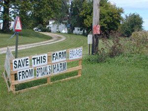
Many urban planners have been alarmed over the last couple of decades as metropolitan areas have
sprung up where farmland or wooded areas once stood. Following new subdivisions have been
strip malls, parking lots and fast food franchises in a not always attractive fashion.


Last year’s election saw a number of states with new governors and some of them are looking at
what can be done to control that kind of unbridled growth. Michigan’s Jennifer Granholm noted it
during her State of the State speech.


“We will develop a cooperative, common sense approach to how we use our land so we can protect
our forests and farms, prevent the sprawl that chokes our suburban communities and threatens our
water quality, and bring new life to our cities and older suburbs.”


Governor Granholm says she wants “Smart Growth.” It’s a popular term, but what is it? What
does it mean?


“I think that Smart Growth is really hard to – certainly hard to describe.”


Barry Rabe is a Professor of Environmental Policy at the University of Michigan’s School of
Natural Resources and Environment. He says “Smarth Growth” sounds great.


“I don’t know anyone who’s really against Smart Growth. But, you can spend a long academic
seminar or actually a lifetime in search of the one common definition of exactly what that means.
Again, it has sort of an intuitive appeal. It resonates. We can all think of examples that are not so
Smart Growth or dumb growth. But, I think clearly this is something that lends itself to differing
kinds of interpretations by different groups.”


And as you ask the people who’ll be sitting at the table debating “Smart Growth,” it becomes clear
that each one has a different definition.


Lynn Egbert is the CEO of the Michigan Association of Home Builders. He says “Smart Growth”
is a private citizen building a home wherever he or she thinks is an ideal site.


“Our basis continues to be and our primary focus is, and it will remain, that it’s private property
rights under the U.S. Constitution that have to be maintained and that is an individual right. It is a
citizen’s right. And we have to work with local and state government to make sure that that’s
achieved and balanced.”


Egbert says the culprit causing urban sprawl is not the choices that landowners make. He says it’s
too much government regulation. Egbert says, generally, municipalities that zone areas into large
lots stop home builders from building more houses on smaller plots of land.


Others also place much of the blame for sprawl on government, but for different reasons. Hans
Voss is with the Michigan Land Use Institute.

______________
“Landowners do have a right to live in the area in which they choose as long as they follow local
land-use regulations and pay the full cost of that lifestyle. And right now the taxpayers in the cities
and across the whole states are actually subsidizing that style of development.”


Voss says to implement “Smart Growth,” the government has to stop subsidizing urban sprawl by
building highways and sewer systems that all of us have to pay for with our taxes instead of just the
residents who benefit from them. He says that money could be better used to revitalize older
suburbs and the center of deteriorating cities.


There are a lot more ideas of what “Smart Growth” means… and there’s a bit of public relations
spinning because of the ambiguity of the term “Smart Growth.”


The University of Michigan’s Barry Rabe says we’ll hear a lot about “Smart Growth” for some
time to come.


“It’s one of these buzz words that everybody likes. But, to come up with a common definition of
it, much less figure out how that would be implemented in public policy is tricky.”


Ultimately, compromise will define “Smart Growth” as states grapple with trying to find better ways
to use land without losing so much farmland to sprawling subdivisions and paving over natural areas
for parking lots.


For the Great Lakes Radio Consortium, this is Lester Graham.

Modeling Program Maps Urban Growth

The U.S. Environmental Protection Agency has recognized a computer model that might help cities better plan for growth. The Great Lakes Radio Consortium’s Lester Graham reports:

Transcript

The U.S. Environmental Protection Agency has recognized a computer model that might
help cities better plan for growth. The Great Lakes Radio Consortium’s Lester Graham
reports:


Attempts to predict urban growth are notorious because they’re often very inaccurate.
The EPA recently gave one of its national awards for ‘Smart Growth’ to the Massachusetts
Executive Office of Environmental Affairs for a statewide Smart Growth computer
program. The EPA says that program helps city leaders to understand the potential
effects of future growth. A town can use it to determine the impact of a proposed
development. It maps out growth patterns and predicts the cost for things such as
additional schools, police, and fire protection. Priscilla Geigis is with the Massachusetts
office. She says it can be used elsewhere.


“We have had some interest from states who are just looking at that as a model. With
some adaptations it could be changed to accommodate some other states.”


One official was quoted as saying the program is like the popular computer game “Sim
City” except this one is for real life.


For the Great Lakes Radio Consortium, this is Lester Graham.

New Sprawl Study Ranks Region

A new study on urban sprawl suggests the Midwest is doing better than some parts of the country, but there are still some trouble spots in the region. The Great Lakes Radio Consortium’s Chuck Quirmbach reports:

Transcript

A new study on urban sprawl suggests the Midwest is doing better than some parts of the
country. But there are still some trouble spots in the region. The Great Lakes Radio
Consortium’s Chuck Quirmbach reports:


A study released by Smart Growth America says California and the south are having the
worst problems with sprawl. But Detroit, Rochester and Syracuse, New York, and the
Gary-Hammond area of Indiana just missed being in the top ten. Researcher Rolf
Rendahl of Cornell University in New York says those are areas where sprawl partly
occurs because of economic distress.


“With very little demand for new development, land is cheaper and people can build
almost anywhere.’


Rendahl also says the suburbs in those areas generally have relatively permissive land use
policies. The study says sprawl can trigger ozone pollution and various traffic problems.
The group recommends more rehabilitation of urban properties and transportation
planning that doesn’t promote sprawl. The National Association of Homebuilders
contends the Smart Growth report ignores housing affordability and consumer choice.


For the Great Lakes Radio consortium, this is Chuck Quirmbach.

Unique Industrial Land Seen in New Light

  • Marian Byrnes has been called the "environmental conscience of the Calumet." She has been a key leader in getting the city of Chicago, and the state of Illinois, to see the value of Calumet's natural areas. Photo by Mark Brush.

In an area in south Chicago you can see the remnants of a steel industry that has had better days – silent smokestacks looming on the horizon, empty parking lots, and for sale signs in front yards. The Calumet region was once a haven for big industry… and because of that it is also home to a list of seemingly endless environmental problems. Many people thought the problems were too great to overcome, but as the Great Lakes Radio Consortium’s Mark Brush reports… that attitude is changing:

Transcript

In an area in south Chicago you can see the remnants of a steel industry that has had better days – silent smokestacks looming on the horizon, empty parking lots, and for sale signs in front yards. The Calumet region was once a haven for big industry… and because of that it is also home to a list of seemingly endless environmental problems. Many people thought the problems were too great to overcome, but as the Great Lakes Radio Consortium’s Mark Brush reports…that attitude is changing:

If you’ve ever driven by Chicago’s south side, you’ve likely seen the smokestacks and factories that dot this old industrial area.

But when you get off the main highway and drive down the back roads of Calumet, you see something you wouldn’t expect – remnants of unique wetlands and prairies. It’s an area where thousands of migrating birds come each spring. Herons, egrets, and cranes carefully pluck their food from these marshes – marshes that are right next to chemical factories and toxic city dumps.

(Bring up sound of sparrows and outdoors)

The sun is setting in this part of the Calumet – some sparrows nearby are settling down for the night – and Marian Byrnes is showing me around the places she’s come to know from living and working here for more than 20 years.

“This land is mostly slag on the banks of Indian Creek, but it’s not considered hazardous.”

“How would the slag get here?”

“Oh, it was waste from Steel Mills – mostly Republic Steel which was north of here.”

(Fade her under + continue outdoor sound)

Marian Byrnes is a retired public school teacher. And at age 76, she volunteers her time as the executive director of the Southeast Environmental Task Force. She repeatedly meets with businesses, community groups, and city and state advisory boards – patiently delivering her message that the Calumet region is worth protecting.

And over the years Marian, and others like her, have steadily worked against a city that didn’t seem to care about the natural areas in Calumet. For many of them, it began more than twenty years ago, when they got a note from the Chicago Transit Authority in their mailbox. The note outlined the Transit Authority’s plan to build a bus barn on their neighborhood’s prairie:

“It was like having our own little forest preserve right behind our houses. You can walk out there, and when you get out – maybe a block or so – you’re not aware that you’re in the city at all. I mean you can’t even see the houses, so it’s just a wonderful place to be in touch with nature.”

They convinced the transit authority to build the bus-barn elsewhere. And in the years that followed they fought off other proposals such as plans to build a toxic waste incinerator, and plans to re-open old city dumps.

But despite those successes, big environmental problems still persist. And the list of contamination is intimidating – heavy metals, PCBs, and leaking landfills. The problems are so overwhelming that when planners in Chicago were thinking about spreading miles and miles of concrete for a new airport, Calumet was thought of as an ideal location.

Kathy Dickhut works in the planning department for the city of Chicago:

“The area does have a lot of environmental problems. Ten years ago the thinking was it was all dirty, environmentally dirty, and that was sort of across the board, …so one way to deal with that is, you know to cover the whole thing up.”

But local environmental and community groups became united in their opposition to the plan. And instead of an airport, the local groups asked the National Park Service to designate the area as an ecological park.

And slowly but surely, the city began to look at the area in a new light:

“I think people didn’t realize just how much opposition there would be to paving over this area. I mean the airport proposal was quite dramatic, and because it was quite dramatic, there was quite dramatic outcry about it – so once that played out – we had to look at it again in a different way. And what we’ve done is really look at the resources that we do have here, which are substantial, and how we can improve those.”

Today, the city appears to have a completely different attitude about the Calumet area. Chicago lawmakers recently passed a land use plan that calls for the best of both worlds. They want to protect and clean up the natural prairies and wetlands – while at the same time – attract new businesses to build on old industrial sites.

City planners hope to balance what may be seen as competing goals (attracting new industries AND cleaning up the environment) by prioritizing where to build and where to preserve. And when they do build – planners are encouraging green building practices. Practices that complement the surrounding natural areas rather than cover them.

Those involved with the project paint a pretty nice picture of what’s to come.

Lynn Westphal is a researcher for the U.S. Forest Service, and works closely with the city of Chicago on the Calumet project: “Imagine an industrial area with the buildings roofs are green. Where instead of turf around – you have native grasses and because of that you have more birds and butterflies… you’ve got bicycle access, people fishing on their lunch breaks…. And it’s not far from becoming a reality. This is all very doable. So it’s not totally hypothetical.”

And in fact, movement toward that new vision is already underway. The Ford Motor Company is building a new industrial park for its suppliers. And many of the green building practices Westphal describes will be used. And the Corps of Engineers is spending more than 6 million dollars to clean up an area known as Indian Ridge Marsh.

But those involved with the transition of this area say that leadership from the community will be the key to its eventual success.

Meanwhile, the Southeast Environmental Task Force will have a new executive director by this summer…

“…and that’ll be someone who’ll learn to do what I’ve been doing for past 20 years, cause I can’t keep on doing it indefinitely.”

“Do you have any advice for them?”

“Have a lot of patience…”

The same patience Marian Byrnes has used when riding a city bus to meeting after meeting, listening to the community, and working with city officials – all in an effort to create what she believes will be a better future for the people in Calumet.

For the Great Lakes Radio Consortium, I’m Mark Brush.

Cities Tackle Regional Planning Puzzle

In the mid-1960’s, the federal government started requiring metropolitan areas to come up with regional plans in order to get government grants for everything from highways to housing. That forced officials from large cities and from the suburbs to sit down at the same table (in many cases for the first time) and think about what was best for the entire region; not just their own town. From this effort, sprang the regional planning movement, but things aren’t always easy, and certainly don’t always go ‘according to plan.’ The Great Lakes Radio Consortium’s Lester Graham reports on one region’s attempt to plan for growth:

There are four major regional planning orgnizations in the Chicago metro area:

Northeastern Illinois Planning Commission
Chicago Area Transportation Study
Chicago Metropolis 2020
Metropolitan Planning Council

Transcript

In the
mid-1960’s, the federal government started requiring metropolitan areas to come up with regional plans in order to get government grants for everything from highways to housing. That forced officials from large cities and from the suburbs to sit down at the same table — in many cases for the first time — and think about what was best for the entire region, not just their own town. From this effort, sprang the regional planning movement. But things aren’t always easy and certainly don’t always go ‘according to plan.’ The Great Lakes Radio Consortium’s Lester Graham reports on one region’s attempt to plan for growth:

If you were to gather around the coffee pot in the morning at just about any place of business in just about any suburb of just about any big city, the topic of conversation would probably not be the weather, or last night’s big game, or even politics. Nope. More than likely it would be about how long it took to get to work. Lots of people drive an hour, ninety minutes, or even longer to make the commute. So, why not move closer, you might ask. The answer could very well be “Can’t afford it.”

Housing costs in many suburbs are so high that the people who teach the kids, fight the fires, and fix the cars in the nice suburbs have to live in other less affluent communities where housing is cheaper. That’s because city officials in many suburbs encourage the building of expensive houses on big lots because it means a better tax base. But that also means many workers need to hop in their cars to get to work in those fancy suburbs.

Of course, when thousands of cars line up bumper to bumper to make the commute, you get traffic congestion.

“If you think it’s bad now, just wait. It’s gonna get worse.”

That’s Frank Beale. He’s the Executive Director of a group named Chicago Metropolis 2020. Metropolis 2020 put together a plan that looked at the Chicago area’s growth patterns and came up with some pretty dire forecasts. According to the study, if the Chicago region conducts business as usual, by the year 2030 there will be a 75-percent increase in auto miles traveled for work, shopping, and normal everyday trips. The time it takes to drive to work will be up 27-percent. And only about seven-and-a-half percent of housing units will be within walking distance of mass transit.

Beale says there’s seems to be a disconnect between local governments’ decisions to encourage big, expensive houses and the resulting need for more roads and additional lanes of traffic to handle all the commuters.

“More equitable
distribution of affordable housing and the employment centers would diminish the demand on the transportation systems. We seem to always only talk about roads. But, we only need roads because of how we’ve configured the land in the region.” Beyond the travel concerns, business as usual — according to the Metropolis 2020 study — means another 383 square miles of farmland will become subdivisions and strip malls in less than 30 years.

Organizations such as Metropolis 2020 are working together to try to educate and persuade the Chicago region’s 275 suburban mayors that the decisions they make will have an effect on the whole region.

Larry Christmas was once one of those mayors. He’s also spent his career running or working for regional planning agencies. He says as a mayor, it’s hard to think about the larger region when you are working to bring good growth to your town. It’s especially hard when regional planners want you to give up local control of land-use for the betterment of the larger region.

“And that’s something the communities don’t want to give up lightly even if there’s a regional argument that the collective local decisions may add up to bad regional development patterns.”

So, those looking at the big picture have their work cut out for them. The regional planners spend a lot of time at meetings with local officials, putting together roundtables to explain plans and trying to schedule meetings between antagonists.

One of the partners of Metropolis 2020 is the Metropolitan Planning Council. Executive Director Mary Sue Barrett says sitting down with those different interests and getting them to consider the reasons for bending a little here and there to adhere to a regional plan can pay off.

“To put it in practical terms, if you can get an environmentalist and a homebuilder and a mayor to agree on something, you can probably go get it done. And that’s what we try to do.”

And the regional planners try to get the mayors to listen on topics ranging from fair and equitable housing, to public transportation, and even taxing systems that sometimes encourage bad development with tax breaks.

But given the kind of expansive sprawl that continues to plague the Chicago metropolitan area, there’s still one question you have to ask of people such as Frank Beale with Chicago Metropolis 2020. That is: who’s listening?

“Well, the general assembly, the legislators are listening, the Mayor, the 275 suburban mayors are listening. They don’t always agree, but they’re listening.”

And as long as they keep listening, the people looking for better regional planning will keep trying to persuade the cities in the suburbs there’s a better way.

For the Great Lakes Radio Consortium, this is Lester Graham.

Small Towns Invite Sprawl

  • Eleven million acres of prime farmland were lost to urban sprawl in a 15 year period. Some small cities are embracing the growth and helping developers circumvent so-called Smart Growth restrictions on sprawl.

Researchers have found that small towns hungry for new tax dollars are making it possible for developers to get around Smart Growth plans. Often the result is urban sprawl that paves over farmland and natural areas. The Great Lakes Radio Consortium’s Lester Graham has the story:

Transcript

Researchers have found that small towns hungry for new tax dollars are making it possible for developers to get around Smart Growth Plans. Often the result is urban sprawl that paves over farmland and natural areas. The Great Lakes Radio Consortium’s Lester Graham reports.


Despite the best efforts of some politicians to slow down the pace of turning farmland into suburbia, the 2000 Census shows population growth is exploding at the edges of Metropolitan areas, and all those people need somewhere to live and shop. So, in the Midwest, often housing developments and shopping malls are built where corn or soybeans grew just the year before.


For example, Kane County, Illinois, as recently as the 1970’s was predominately farmland. Now with more and more people moving there, only about half the county is left for farming.


Randall Road cuts through the heart of the county, although housing developments and retail stores are starting to infringe on the country setting, on one side of the road you can still see rows of crops and pasture, and on the other side of Randall Road, it’s nearly solid shopping malls and subdivisions. But in the middle of all that development, there’s still one dairy farm. Mike Kenyon and his family still grow hay and corn, and milk cows here. But their fields are surrounded by three sprawling towns. Kenyon says Randall Road used to be the line where planners said urban sprawl would stop. They were so confident that they even said so in their planning document for the year 2020.


“And they drew a line in the county and they said ‘we want the growth to occur here and we want to maintain this as rural, as farms. Well, how did developers get around that? Well they go to a little village and they say ‘Well, we’ll put a big housing development over here. Please, annex us and this’ll be more revenue and they’ll even have a sewer system when we get done.’ So, that’s what happens; they kind of bribe the villages so they get around the 2020 plan.”


And that, Kenyon says, is what’s now happening on the other side of Randall Road where Kane County was supposed to remain rural. Kane County officials are trying to implement all kinds of programs to save the remaining farmland from urban sprawl, or at least keep urbanization to certain areas of the county. But at the town and village level, many local politicians see growth as nothing but good and are willing to expand their city limits to include developments. That’s because those developments help increase their tax revenue.


The story is not unique to the Chicago region. It’s being repeated throughout the Midwest and the Great Lakes, as well as across the United States.
So much so that millions, yes millions of acres of prime farmland in the U.S. have been lost in a little more than a decade. Rich Green is a geographer at Northern Illinois University. He’s been tracking the fringes of the ever-growing Chicago Metropolitan area. He’s been adding up just how much former cropland has been turned into suburban lawns and parking lots.


“What we found is this: the nation between 1982 and 1997, that’s a 15 year time period, lost about eleven million acres of prime farmland, cropland, to urban development.”


Green also found, perhaps coincidentally, that an identical amount of land, eleven million acres of rangeland was plowed up and put into crop production during the same period.


“What we’ve been looking at is losing the nation’s best farmland in places like Chicago and other metropolitan areas in the Midwest, and replacing it with marginal lands in the arid West which requires more inputs, particularly water, irrigation.”


Green says shifting farming to less productive and more environmentally damaging land might not be the intent of the small towns that want to grow, but that’s the apparent result.


Just off campus at Northern Illinois’ Social Sciences Research Institute, Director Harvey Smith says Midwest states such as Illinois should take the time to better learn and weigh the costs of continued urban sprawl.


“Economically, Illinois relies very, very heavily on its agriculture. And, it is also the case that a lot of the very rich farmland is in the northern tier of the state which is closest to the moving fringe of the suburbs.”


Many times government at a more regional level, such as at the county level, is struggling with balancing development and farmland preservation. Even though it’s something of a contradiction, Smith says the people who move to the suburbs’ fringes causing further urban sprawl, actually want to preserve some of the farmland.


“The fact is that many of the people who move into the suburbs, while they like the sort of scenic quality of a farm or two over the hill, aren’t in a position to stop the disappearance of the farms themselves. It requires cooperation between local and regional governmental agencies to make a real effort to protect these qualities that are likely to disappear if they don’t.”


For some towns, it’s too late to recover the rural character and small town charm they lost to development, but for those at the fringes of the sprawling large metro areas with adherence to Smart Growth planning, some planners believe there’s still the opportunity to preserve a little of the setting of the suburbs that drew so many people there in the first place.

SMALL TOWNS INVITE SPRAWL (Short Version)

  • Eleven million acres of prime farmland were lost to urban sprawl in a 15 year period. Some small cities are embracing the growth and helping developers circumvent so-called Smart Growth restrictions on sprawl.

The U.S. has lost millions of acres of productive farmland in the last decade to urban sprawl. Researchers say state and county officials are seeing Smart Growth plans circumvented by politicians in small cities. The Great Lakes Radio Consortium’s Lester Graham reports:

Transcript

The US has lost millions of acres of productive farmland in the last decade to urban sprawl. Researchers say state and county officials are seeing smart growth plans circumvented by politicians in small cities. The Great Lakes Radio Consortium’s Lester Graham reports.


Most states have passed legislation or are looking at doing so to reduce urban sprawl. Even some counties are working to restrict development to certain areas. But often developers approach small cities, promising increased tax revenues and infrastructure if the town annexes large areas of surrounding land for the developers. Rich Green is a geographer at Northern Illinois University. He says some small town officials don’t see past their own city limits.


“And in some respects, they may overlook the regional concerns to benefit their own territory, developers, shopping malls, retailers, playing one municipality off the other in terms of getting the best deal to locate.”


And so long debated plans to manage growth become nothing more than lines on a map, while natural areas and farmland are replaced by subdivisions and parking lots. Green says that’s led to eleven million acres of prime farmland being taken out of production in the fertile Midwest and East in a 15 year period due to urban sprawl. For the Great Lakes Radio Consortium, this is Lester Graham.

PAYING FARMERS TO PRESERVE LAND (Part 1)

Following World War Two, many Americans moved from cities to the suburbs for clean new houses and big lawns. The resulting urban sprawl eventually became a concern in eastern states because of their large populations and small land mass. But sprawl has only recently become an issue in the once land-rich Midwest. This spring, 135 people from Ohio, Michigan, and Indiana took a bus trip to the east coast to get ideas about containing development and protecting farmland. The Great Lakes Radio Consortium’s Julie Grant reports:

ROOM FOR DEVELOPMENT &Amp; FARMING? (Part 2)

Some Midwesterners concerned that urban sprawl is eating up too much farmland recently took a bus trip to the east coast. They wanted to visit states such as Maryland, New Jersey, and Pennsylvania. Planners in those states have been dealing with the problem of too many people and not enough land for decades. The bus tour participants looked at different ways to preserve open spaces while still allowing development. The Great Lakes Radio Consortium’s Julie Grant looks at a program that doesn’t cost taxpayers money:

Downtown Residential Development on the Rise

For decades, Americans have been fleeing the grit of city life for the serenity of suburbia. And while that trend still continues, a new pattern is emerging. The long commutes that are often part of suburban life are driving many people back to the city. The Great Lakes Radio Consortium’s Steve Frenkel reports from Chicago: