Native Americans Lose Land to Climate Change

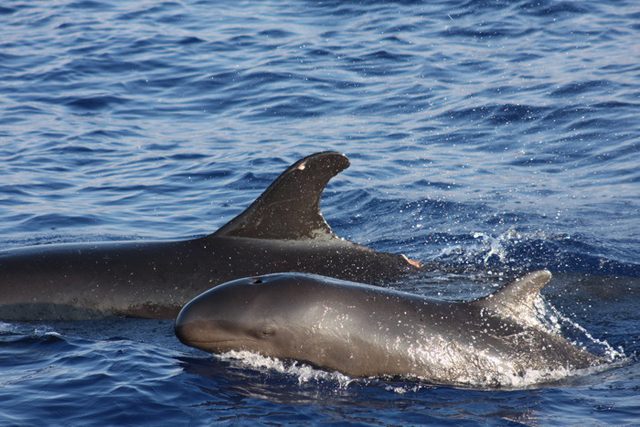
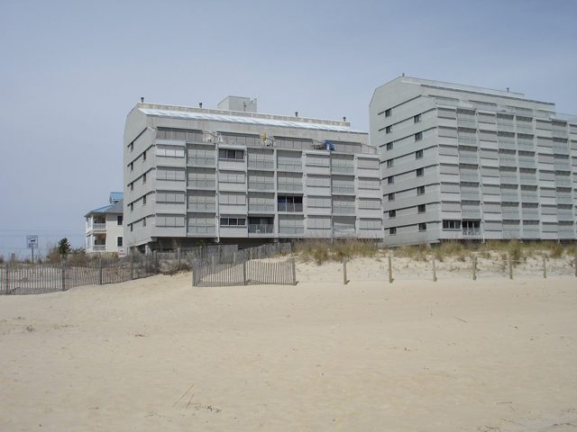
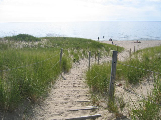
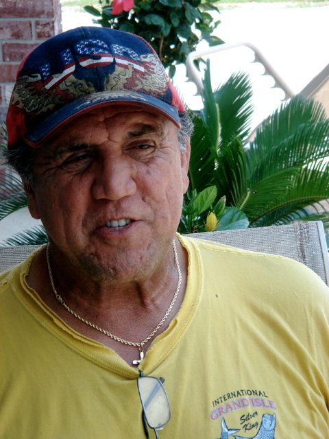
  • Choctaw Chief Albert Naquin has watched his tribe's island - the Isle de Jean Charles - go from four miles across to a quarter mile across. (Photo by Samara Freemark)

Over the next century, rising
sea levels will change coastlines
all over the world. But the impact
might be most dramatic in South
Louisiana. A study out last month
predicts the state will lose up to
5000 square miles in the next
century – a chunk of land the size
of Connecticut. If the report’s
authors are right, that means a
lot of people in Louisiana are
going to have to relocate – become
climate refugees. Samara Freemark has the story of one of
the first communities to be displaced:

Transcript

Over the next century, rising sea levels will change coastlines all over the world. But the impact might be most dramatic in South Louisiana. A study out last month predicts the state will lose up to 5000 square miles in the next century – a chunk of land the size of Connecticut. If the report’s authors are right, that means a lot of people in Louisiana are going to have to relocate – become climate refugees. Samara Freemark has the story of one of the first communities to be displaced:

It was sometime in the mid-1970s that Albert Naquin first realized that Isle de Jean Charles was sinking. Naquin had grown up on the island. He’s the chief of a group of Choctaws who have lived there since the 19th century – and when he was a kid, it was a pretty good community: it had stores, a couple of churches, horse pastures and fields. But those are all gone now.

“Salt water kept coming in, faster and faster, and now it’s basically just beach.”

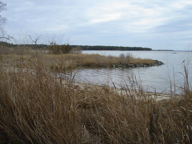
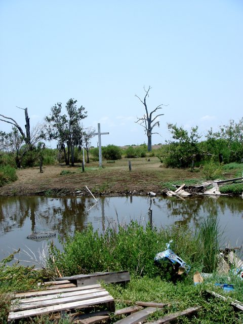
Isle de Jean Charles is sinking into the Gulf of Mexico.

The list of reasons why is long. There’s subsidence- that’s the natural phenomenon where delta regions kind of settle down on themselves. There are the dams that block the sediment that used to wash down and build the land back up. There are oil company canals that slice through the wetlands, hurricanes that tear up the island’s coastline, and, of course, there’s rising sea levels.

All together they explain why Isle de Jean Charles used to be about 4 miles across and now has shrunk to a quarter mile.

“Now, we see the disaster that is Isle de Jean.”

We’re in Naquin’s pickup truck, and he’s driving me out to the island.

“See this little house moved across the way, this house. These 1, 2, 3 are deserted.”

Naquin himself moved off the island awhile ago. But for years he was happy to support families who chose to stay. In fact, when the US government came to him in 2002 and offered to pay to help people move off the island, he resisted.

“So, I said, ‘what they gonna do, tell us they’re gonna move us there and then next thing send us a bill for the house?’ You know, so I said, ‘no, that’s just a modern day Trail of Tears. We’re not moving.’”

But lately Naquin has just gotten tired. Tired of evacuating people before storms, tired of helping them rebuild after, tired of watching the sea nibble away at the island.

And so he decided – enough. For the past year he’s been on a mission to convince the 25 families still living on the island to abandon it.

“They’re not going to save the island. It’s going to be gone. Either we move now or we move later, ‘cause we will move.”

But not everyone is ready to leave.

(sound of greeting and talking)

Naquin pulls over to talk to Dominique Dardar.

Dardar’s house was leveled by Hurricane Gustav last summer. He’s rebuilding it with pieces of other houses he’s found blowing around the island- bits of roof and siding. Dardar says he’s not moving.

“I ain’t never gonna move. I’m gonna stay over here. That’s my territory.”

Across the street Wenselas Billiot lives in a house raised 13 feet in the air.

Billiot is Naquin’s brother in law. He’s in his 80s and has lived on the island his whole life. I ask him what he’ll do if the island shrinks any more.

“That’s going to be rough. But, as long as I can stay, I’ll stay. I was born and raised on the island. As long as I can stay here I’m going to stay.”

Albert Naquin hasn’t given up. He thinks if he can get everyone to agree, the government will help the tribe get a big piece of land where they can all relocate as a group. He’s already thinking of names for the new town.

“We could say, Island Number Two, or Isle de Jean Charles New Beginning, or something like that. But I think we just name it Isle de Jean Charles 2. I think that has a good sound to it.”

In short, Naquin is trying to figure out how to keep the idea of Isle de Jean Charles alive, even when the island itself no longer exists.

It’s a challenge many Louisiana communities could soon face.

For The Environment Report, I’m Samara Freemark.

Related Links

The Case of the Disappearing Dolphin

  • A false killer whale, which is actually a type of tropical dolphin, with calf (Photo by Deron Verbeck, courtesy of iamaquatic.com)

Commercial fishing in the oceans of the US has done a lot to reduce
accidentally catching marine mammals such as dolphins. But there are
still problems. Ari Daniel Shapiro reports on concerns about one kind
of tropical dolphin called the false killer whale:

Transcript

Commercial fishing in the oceans of the US has done a lot to reduce
accidentally catching marine mammals such as dolphins. But there are
still problems. Ari Daniel Shapiro reports on concerns about one kind
of tropical dolphin called the false killer whale:

Jim Cook has been a fisherman in Hawaii for 18 years.

“You know, it used to be real simple: catch a fish, sell it, and go
back out and try and catch another one.”

Now he owns a company that operates six fishing vessels. Cook’s
ships catch deep swimming sashimi-grade tuna that ends up in sushi
restaurants across the US. They use a technique called longline fishing.

“We have around 45 miles of mainline to which we attach floaters
and 2200 to 2500 baited hooks.”

“The regulations imposed on the Hawaii longline fishery are
probably the most restrictive regulations on any longline fishery in the
world.”

That’s Bill Robinson. He’s an administrator with the National
Marine Fisheries Service. And these regulations he’s talking about are
meant to reduce bycatch. That means catching marine animals other than
the tuna. As a result of these policies, sea turtle bycatch has dropped
by more than 90-percent and seabird bycatch by 95-percent.

Things are looking up, but now there’s another problem. The numbers of
another kind of animal – the false killer whale – are declining. No one
knows why they’re disappearing. It might be related to longline
fishing, but it’s just not clear.

Robin Baird’s a biologist with Cascadia Research.

“There’s a whole variety of lines of evidence that imply the false
killer whale population around the main Hawaiian islands has declined
dramatically over the last 20 years. And I think it’s clearly the most
serious conservation or management issue for whales and dolphins in
Hawaiian waters today.”

Baird thinks the decline is partly related to fewer numbers of tuna
and other species false killer whales eat. He also suspects that the
false killer whales might be moving farther offshore, where they could
get hooked when trying to eat the tuna caught by the longline fishery.

So the question is: should the National Marine Fisheries Service come up
with even more regulations for the longline fishery in case more false
killer whales move offshore looking for tuna.

Bill Robinson with the Fisheries Service isn’t so sure that they
actually go that far offshore.

“That’s speculation, and it may or may not be true. What we
don’t really know is what the range of each population is.”

So, really, at this point, it’s anyone’s guess why the false killer whale numbers are declining.

The biologist, Robin Baird, is concerned that nothing’s being done.

“Unless something is done to change the factors that are
influencing the population, it probably will continue to decline.”

The environmental group Earthjustice and a coalition of
conservation groups have sued the National Marine Fisheries Service over
failing to develop a plan to protect the false killer whales.

The agency has not responded officially to the lawsuit yet. But Bill
Robinson says an action plan is in the works.

“Hopefully by the fall, we’ll be able to not only appoint the
team, but have the team begin work on a take recovery plan that will
make recommendations to the agency to reduce the incidental take of
false killer whales in the fishery.”

Such a plan might end up costing the commercial fishers money. But
Jim Cook says he’s willing to pay. That’s because false killer whales
pick fish off his lines. They eat the caught tuna before the fishers
can haul them in. That can mean a lot of lost income.

“We would very much welcome any methodology almost
irrespective of cost because we’re suffering quite a bit economically as
it is.”

But the National Marine Fisheries Service first has to find that
methodology.

For The Environment Report, I’m Ari Daniel Shapiro.

Related Links

Sea Levels Threaten Coastal Towns (Part One)

  • The boardwalk in Ocean City, Maryland. Before beach replenishment, you could get your feet wet standing underneath the boardwalk. Now, as you can see, the water is 200 feet away. (Photo by Tamara Keith)

It’s beach weather – and along the mid-Atlantic one of the most popular beaches is Ocean
City, Maryland. For years, engineers have been battling back the ocean to save the beach
and the town. And as Tamara Keith reports, that fight is only going to get tougher and
more expensive if predictions of sea level rise from climate change become a reality:

Transcript

It’s beach weather – and along the mid-Atlantic one of the most popular beaches is Ocean
City, Maryland. For years, engineers have been battling back the ocean to save the beach
and the town. And as Tamara Keith reports, that fight is only going to get tougher and
more expensive if predictions of sea level rise from climate change become a reality:

When the sea level rises, Ocean City feels it. It’s on the front lines – a barrier island on
the edge of the Atlantic.

(sounds of water)

Terry McGean is the city engineer for a town he describes as a working class resort.

“Our industry is tourism, and the real reason people come here is the beach.”

But in the 1980s, that beach was reduced to a narrow strip. Not so today, all thanks to a
massive, and expensive, beach replenishment project. In 1991 countless tons of sand
were brought in, dunes were built. But that wasn’t the end of it.

To keep up with erosion, McGean says the beach here at Ocean City has already been re-
nourished 4 times.

“Approximately every 4 years we’re doing a re-nourishment project. To give you an idea
of the scale, that’s 100,000 truck loads of material that we’ll put on here. Though it
doesn’t actually come on a truck? No. It’s pumped in a dredge from out in the ocean.”

It is a constant fight, because the waves keep coming, keep pulling the sand back out to
sea. Scientists say this is partially just normal erosion. But some of it at least can be
blamed on global climate change and sea level rise. Over time, they say, the share of the
problem caused by climate change will grow.

“If you hadn’t done the beach replenishment do you have any sense of what this would
look like right now. There probably would have been no public beach left in many of
these areas.”

So far fending off the sea has cost $90-million, split amongst local, state and federal tax
dollars. But engineers estimate some $240-million in storm damage has been prevented.

“Holding back the sea is an economic proposition. If you’re willing to spend the money,
the sand exists to elevate any given barrier island.”

Jim Titus is the project manager for sea level rise at the Environmental Protection
Agency. And he’s been sounding the alarm about climate change for years. And he says
policy makers and the public will eventually have to decide which beaches, which
communities are worth saving.

“The challenge for communities like Ocean City is to persuade everyone else that they
are one of those cities that are too important to give up. And then to get their residents to
cooperate in doing what it takes to do to gradually elevate the entire community with a
rising sea.”

But if you think in geologic time, like University of Maryland professor Michael Kearney
does, there isn’t a whole lot of hope for barrier islands like Ocean City.

“It’s essentially a pile of sand. There’s really nothing permanent about it.”

Kearney studies coastal processes.

“The long term prospect of any barrier surviving the projected rates of sea level rise, even
at the moderate rates – the so-called moderate rates, that the IPCC predicted is pretty
slim.”

Ocean City engineer Terry McGean just isn’t buying it. He thinks Ocean City can survive
sea level rise.

“I think that we can design towards it and we can probably build towards it and with
responsible actions we can live with it.”

As long as there’s enough sand and money to keep it going.

For The Environment Report, I’m Tamara Keith.

Related Links

Sea Levels Threaten Coastal Towns (Part Two)

  • A living shoreline near the Chesapeake Bay in Maryland. The native grasses and sandy shore provide habitat for terrapins, the University of Maryland mascot. (Photo by Tamara Keith)

Scientists are pretty certain climate change is going to cause the sea level to rise. It’s
happening already, actually. In communities around the Chesapeake Bay, people are
getting a sneak preview. Tamara Keith reports some people there are trying to work with
nature rather than resist it:

Transcript

Scientists are pretty certain climate change is going to cause the sea level to rise. It’s
happening already, actually. In communities around the Chesapeake Bay, people are
getting a sneak preview. Tamara Keith reports some people there are trying to work with
nature rather than resist it:

(sound of kids planting)

It’s been raining in Woodland Beach. The community is just off of the Chesapeake Bay
in Maryland. The ground here is so soft you sink into it. Mud is everywhere. And that’s
just fine with the volunteers planting native grasses on a sloping hillside.

Stephen Hult is trying to keep things in order.

“And when we plant them we want them all the way down. I’m telling everyone twice.”

Hult heads up shoreline restoration projects for the local property owners association.
And there’s a lot of shoreline to restore.

“The shoreline, in parts of the community since the 1930s, have eroded 20 feet. Year to
year, one barely notices, but if you look at aerial maps of what it used to be like
compared to what it is, it really is quite dramatic.”

There’s been tons of erosion here. The land all along the mid-Atlantic coast is also
slowly sinking. Combine that with global sea level rise and you get erosion in overdrive.

Hult says the community is trying to restore the beach with rock and dirt and sand and
grasses to hold it all together. This is what’s called a living shoreline.

“We have now, with this project it will be well over half a mile of living shorelines that
we’ve installed.”

It’s a relatively new concept, a more natural approach to the gnawing problem of
shoreline erosion. Living shorelines create buffer between the water and homes. They are
kinda like the tidal wetlands that used to be here – before property owners started building
sea walls, also called bulkheads.

Jana Davis is associate director of the Chesapeake Bay Trust. It’s one of the organizations
funding this shoreline restoration. And Davis also happens to live here.

“It’s a wonderful alternative that provides just as good shoreline protection while also
providing a lot of really important habitat benefits that a bulkhead or rock sea wall does
not provide.”

Good for wildlife, and she says, it’s adaptive in the face of sea level rise.

“If sea level were to rise another foot, for example. The marsh could kind of migrate
inland, whereas if you had a bulkhead obviously there’s no migration because it can’t
move.”

But most of the people with bulkheads are NOT buying it. They want to protect their
property from the sinking land and rising water, and a lot of them don’t think a bunch of
rocks and grass are going to cut it.

Kevin Smith is chief of restoration services for the Maryland Department of Natural
Resources.

“There’s many places you can go and look at miles of shoreline and not see any natural
shoreline at all. It’s all armored off.”

Smith met me at a nature center along the bay. A few years ago, a stretch of bulkhead
here was replaced with a living shoreline. The natural ebb and flow of these shorelines
has made some property owners skeptical. They want the shoreline to stay put.

“If these types of projects don’t protect that shoreline from erosion, then homeowners are
not going to want to do it.”

But Smith insists these projects do work, and long term they’re going to be more
sustainable and more flexible than bulkheads – which over time will lose the battle
against the constant pounding of the rising sea.

For The Environment Report, I’m Tamara Keith.

Related Links

Building Penguin Beach Homes

  • The penguins' natural shelter (their own dung) is being removed from the landscape for fertilizer. So, conservationists are supplying penguins with artificial homes in which to nest. (Photo by Frank Olivier)

Along with lions and elephants, Southern Africa is home to a species of penguin. But the African penguin population is dwindling – and scientists are trying to turn things around for the bird. Ann Dornfeld reports:

Transcript

Along with lions and elephants, Southern Africa is home to a species of penguin. But the African penguin population is dwindling – and scientists are trying to turn things around for the bird. Ann Dornfeld reports:

Dyer Island sits just off the coast of the Western Cape of South Africa. It’s tiny, and pretty much consists of two things. Rocks. And birds.

Along with Cape cormorants, Hartlaub’s gulls and swift terns, Dyer Island is the nesting ground for hundreds of African penguins. Although they’re half the size of the Emperor penguins from that movie you might have seen, the species act a lot alike – waddling, awkwardly hopping, and squawking at each other over territory disputes. But today, these African penguins aren’t doing much of anything. That’s not them you hear. They’re mostly just standing still, trying to catch a breeze in the 90-degree heat.

“If you have a look here, you get an idea of just the heat stress of the birds. See this bird over here who’s just sort of standing, gasping, that’s an indication of heat stress.”

Lauren Waller monitors the penguin colony for Cape Nature. That’s the provincial conservation department. Waller says penguins used to find protection from the heat by burrowing into centuries’ worth of bird guano. That allowed them to keep cool, and lay their eggs out of predators’ reach. But in the 19th and 20th centuries, people dug out the guano between the rocks along the Southern Africa coast and sold it as fertilizer.

“And now what you’ve got if you have a look around the island is just – it’s rock, and the penguins can’t burrow into that. And so it now forces them to breed on the surface.”

When penguins make their nests out in the open, kelp gulls can snatch their eggs and chicks. And because penguins breed during African summers, the heat can be overwhelming. Parents often leave the nest just to cool off at sea, and their eggs or chicks die. It will take decades for the guano to build back up.

Scientists are trying to help the penguins out. They’re building nests for them. Waller says Dyer Island is the main testing ground.

“The nests are made out of fiberglass mold and they sort of mimic natural burrows that the bird would make in the ground. They’re kind of like a really small igloo shape, and big enough that you can fit two adult birds inside and their chicks as well.”

The nests are covered with rocks to prevent a greenhouse effect inside the igloos. Waller says they’re experimenting with different materials and nest arrays to see whether the penguins prefer their igloos in a cul-de-sac pattern, or a secluded ocean view. Some nests never catch on, but others have become prime real estate.

“Here you can see we have a colony of 15 nests, and already nine of them are occupied and it’s not their peak breeding yet. So this specific colony is looking really, really good.”

We peek inside one of the plastic igloos where a mother is guarding two fuzzy brown chicks.

“She’s turning her head from side to side.”

“Yeah, it’s a kind of aggressive, stay-away kind of behavior. But if you look behind her you can see the little heads sticking out!”

Waller says as successful as the artificial nests have been, commercial overfishing of sardines and anchovies also affects chick survival. At one well-protected nest a few yards away, she finds an abandoned egg and a dead chick. She says it may be that the parents couldn’t find enough fish.

“It is hard. Knowing their numbers are just going down every year. And you become quite desperate to do something so that these birds don’t have these breeding failures.”

The South African government has banned fishing around one island with penguin colonies to see whether it makes a difference in the birds’ survival rates. Waller says she’s hopeful that now is the turning point for African penguins.

For the Environment Report, I’m Ann Dornfeld.

Related Links

The Legacy of the Exxon Valdez

  • A NOAA scientist surveying an oiled beach to assess the depth of oil penetration soon after the spill (Photo courtesy of NOAA)

Twenty years ago this week, an oil tanker ran aground on a rocky reef in Alaska’s Prince William Sound. The Exxon Valdez spilled more than 11 million gallons of crude oil. It’s considered to be perhaps the biggest ecological disaster in US history. Ann Dornfeld has this look at how oil spill prevention and preparedness have changed in the two decades since Valdez:

Transcript

Twenty years ago this week, an oil tanker ran aground on a rocky reef in Alaska’s Prince William Sound. The Exxon Valdez spilled more than 11 million gallons of crude oil. It’s considered to be perhaps the biggest ecological disaster in US history. Ann Dornfeld has this look at how oil spill prevention and preparedness have changed in the two decades since Valdez:

The call came in just after midnight.

“Ah, evidently leaking some oil and we’re gonna be here for a while.”

Court records indicate Captain Joseph Hazelwood was likely drunk when the Exxon Valdez ran aground.

There was hardly any clean-up equipment on hand. No plan for action. The location was remote.

Oil polluted a stretch of Alaskan coastline the length of the entire west coast of the U.S. The oil killed fish, sea otters, harbor seals and an estimated quarter of a million birds. Today, there is still oil on some beaches.

Twenty years later, a cargo vessel has just reported a spill of 160
gallons of oil in Washington state’s Commencement Bay. Investigators
have filled the “Spill Situation Room” in the state Department of Ecology.

“Who’s responsible for actually maintaining
the bow thruster, when was the last time they performed maintenance on it?”

“You mean one of the staff on board?”

“Yeah.”

Spill Response Manager David Byers says coastal states learned a lesson from Exxon Valdez, and developed rapid response systems like this.

“We’ve got crews headed up in a helicopter to do on-
water observations, we’ve got response resources on the water headed out to do containment when we find the location of the oil.”

Byers says the state handles dozens of spills this size each year, making it somewhat of a well-oiled machine.

After the Exxon Valdez, the state of Washington put in place some tough prevention standards. But the U.S. Supreme Court ruled against the state.

The court ruled the state was making safety demands of oil companies that only the federal government could make.

Mike Cooper is Chairman of the state’s Oil Spills Advisory Council. He says that ruling is one reason why small oil spills are common in Washington’s bays. He says other states have come up against the same restrictions.

“When the Massachusetts legislature passed strict laws,
the United States Coast Guard and the industry did the same thing that they did to the people of Washington state. They sued the people of the state of Massachusetts and said, ‘We’ll decide if industry has to pay.'”

The federal Oil Pollution Act did raise industry’s liability and the amount of federal money available in the event of a spill. It also requires oil tankers and barges in U.S. waters to be double-hulled by 2015. The Exxon Valdez’ single hull was easily gouged open when it ran aground.

Today, most U.S.-flagged tankers and barges are double-hulled. Most foreign tankers aren’t yet.

But there’s no law requiring a second hull on cargo ships. Bruce Wishart is Policy Director for People for Puget Sound. He says it’s cargo vessels that are most likely to spill oil.

“It’s commonly assumed that oil tankers pose the
single greatest threat in terms of an oil spill. There are actually many, many more cargo vessels plying our waters that pose a very significant risk simply because they carry a lot of fuel on board.”

In 2007, the cargo vessel Cosco Busan spilled 53,000 gallons of oil into San Francisco Bay. Thousands of birds died, including endangered species. A fully-loaded cargo ship can contain 40 times more oil than what leaked from the Cosco Busan.

So, while oil tankers have become safer in the two decades since the Exxon Valdez, the nation’s waterways still remain at risk of a major spill.

For The Environment Report, I’m Ann Dornfeld.

Related Links

Canada’s Blue Flag Beaches

  • Toronto is now getting its beaches certified as safe by an international program called 'Blue Flag' (Photo by Julie Grant)

Beaches on the Great Lakes have
been closed a lot this summer because of
pollution. But instead of raising the
white flag of surrender, in Canada, they’re
starting to raise a blue flag. Julie Grant
reports the Blue Flag Programme certifies
a beach is safe:

Transcript

Beaches on the Great Lakes have
been closed a lot this summer because of
pollution. But instead of raising the
white flag of surrender, in Canada, they’re
starting to raise a blue flag. Julie Grant
reports the Blue Flag Programme certifies
a beach is safe:

(sound of beach)

It’s a clear, cool summer morning by Lake Ontario. Some
people are playing volleyball, others are walking along the
boardwalk at Woodbine beach, on the east side of Toronto.
Nobody is swimming in the lake.

Beach person 1: “No I don’t swim here.”

Beach person 2: “I grew up here, and I’ve never actually
swam in Lake Ontario. Sometimes they were closed and it
was always off and on, so it never seemed like a good thing
to do.”

Beach Person 3: “It’s gross, man. It’s pretty nasty. One
time I found a couple of Band Aids. After that, I was like, ‘I’m
not going back in this water.’”

City leaders say those views are outdated.

Lou DiGeranimo is Toronto’s general manager of water.
He’s in charge of everything from drinking water to sewers
and storm water runoff.

DiGeranimo says the Lake’s bad reputation lingers
from the time when Toronto was a major port for lumber, for
shipbuilding, and for foundries.

“When you talk to certain people in the city, they remember
the old industrial heart of our city and they think that Lake
Ontario is polluted and you shouldn’t swim in it. Well we beg
to differ. You can swim in it and our water quality is actually
quite good.”

DiGeranimo is trying to change the public image of Lake
Ontario one beach at a time. So far he’s been able to get six
Toronto beaches certified as safe by an international
program called Blue Flag. DiGeranimo says the blue flag
shows that someone besides the city is checking up on the
beaches.

“There’s an external group, Environmental Defense, that
actually, we work with. And they themselves are part of a
larger international group who come round and audit to
make sure that we are following the program accordingly.”

Thousands of beaches in The Caribbean, Europe and South
Africa fly blue flags. Toronto has some of the first beaches
in Canada to be certified by the program. The city has to
test water quality every day. It also has to provide
lifeguards, recycling containers, and environmental
education programs.

But water quality is usually the biggest obstacle for beaches
trying to get a certification.

(sound of beach)

A blue flag waves in the wind at Toronto’s Woodbine beach.
But not without considerable cost. The sewer used to
overflow regularly here into Lake Ontario. The city built
underground retention tanks to store sewage overflow until it
could be sent to a treatment plant.

But multi-million dollar sewer fixes usually are not possible
for many cities.

So DiGeranimo says people also need to take action at
home. Toronto has been trying to educate people to be
careful what they wash down the drain. And DiGeranimo
says Toronto banned the use of some lawn chemicals
because they were polluting the Lake.

“If I took a bag of chemicals and then just dumped it in the
river, I could charge you for impairing the water quality. But
if you dumped it on your lawn first, and then it ended up in
the creek, that would be okay. So in the city we passed a
bylaw that restricted the use of certain chemicals.”

That kind of ban would be a tough sell in most U.S. cities. It
wasn’t easy in Toronto either.

But Jody Fry says it’s helped the city earn Blue Flags at
many beaches. Fry is Canada’s national Blue Flag program
coordinator. She says people on all shores are starting to do
the work to certify their beaches.

“It raises awareness both at the beach and throughout the
community of what actions people can take to help improve
the water quality. Which, I think, people are looking for,
because they want to help contribute to protecting the
environment.”

The city of Toronto hopes to raise Blue Flags at five more
beaches soon. For now, they want to spread the word – if
you see a Blue Flag flying at the beach, it’s a signal that you
can trust that the water is clean for swimming.

For the
Environment Report, I’m Julie Grant.

Related Links

Botulism and the Beach

  • The beach looks beautiful... until you stumble on dead birds and fish killed by Type E botulism. (Photo by Rebecca Williams)

A deadly toxin is spreading across
the Great Lakes, killing fish and birds.
Rebecca Williams reports scientists are
trying to put the puzzle together as quickly
as they can:

Transcript

A deadly toxin is spreading across
the Great Lakes, killing fish and birds.
Rebecca Williams reports scientists are
trying to put the puzzle together as quickly
as they can:

(sound of waves lapping the beach)

It’s one of those perfect beach days. Not too hot, not too crowded. Everything’s
just right.

Unless you don’t like rotting fish and dead birds full of maggots.

Hunter Brower is hanging out at this Lake Michigan beach. He says he’s seen a
lot of dead gulls here in recent years.

“It’s disgusting. We’re out here to enjoy our time and it’s just not right.”

The birds and fish are being killed by Type E botulism. Basically, it’s food
poisoning. For about a decade now, botulism has been killing huge numbers of
birds in the Great Lakes.

We’re talking about more than 75,000 birds – and scientists think that’s probably
a very conservative estimate. That’s because birds could be dying and not
reaching the shore. And it’s very hard to know how many fish are getting killed.
They’re harder to diagnose.

“It’s really one of nature’s most potent toxins.”

Mark Breederland is with Michigan SeaGrant. He says some studies show the
toxin can paralyze fish.

“They can actually lose their orientation and be bobbing up and down vertically
and that would be easy pickin’s if you’re a loon.”

Loons and other birds eat those poisoned fish, or, even grosser, they’ll eat the
maggots in dead birds on the beach, and get sick. The toxin can make birds lose
control of their neck muscles. Their heads fall in the water and they drown.

Beaches full of dead fish and birds aren’t great for tourism. But scientists are
more worried about what this means for endangered species – from the giant lake
sturgeon to the tiny piping plover.

Mark Breederland says they’re also worried about the thousands of migratory
birds that get killed on their way south in the fall.

“They’re just driving down their migratory highway, pulling over for a rest stop to
get something to eat, and that’s their last and final resting spot.”

So scientists are trying to pin down what’s going on.

There’s one main hypothesis. It involves some nasty little critters: invasive zebra
mussels and their cousins, the quaggas. They got into the lakes in the ballast
water of foreign ships.

Both mussels suck in lake water and filter it. They’ve made the lakes a lot clearer
than they used to be.

The clearer water means more sunlight can reach the lake bottom, and that
kick-starts algae growth. When the algae die, it sucks oxygen out of the water.
And, all of that is perfect for a bacterium that produces the botulism toxin to go forth
and multiply.

Okay, now, remember those pesky mussels? Scientists suspect they can take in
the toxin but they’re not affected by it. But fish that eat the mussels get sick.

One fish in particular loves to eat mussels. It’s the invasive round goby. And
there are lots and lots of gobies in the Lakes. That could mean lots of poisoned
snacks for bigger fish and birds.

Researchers have a bad feeling about all this, and they’re trying to confirm their
hunches.

(sound of boat engine starting up)

Brenda Moraska LaFrancois is headed out on Lake Michigan to investigate. She’s
part of a team that’s collecting samples from the lake bottom.

She says this is a tough mystery to unravel.

“These are really complicated systems and unfortunately they’re continuing to
change.”

As soon as scientists think they have a handle on what’s going on, some new
invader gets in and messes everything up again. So it’s really hard to know what
could be done to stop the outbreaks.

The experts say, if you go to the beach, it’s safe to swim. But you shouldn’t eat any
fish or waterfowl that seem sick.

Your local wildlife managers might tell you: don’t touch it, but get something to
bury the dead animal down in the sand, so other birds won’t feed on it and spread the
toxin.

For The Environment Report, I’m Rebecca Williams.

Related Links

More Money for Polluted Hot Spots?

  • Lake Superior's South Shore, Wisconsin (Photo by Dave Hansen, courtesy of the EPA)

Congress might vote this fall
on a plan to triple the amount of money
for cleaning up pollution hot spots
around the Great Lakes. Chuck Quirmbach
reports:

Transcript

Congress might vote this fall
on a plan to triple the amount of money
for cleaning up pollution hot spots
around the Great Lakes. Chuck Quirmbach
reports:

The Great Lakes Legacy Act is supposed to remove contaminated sediment from harbors.
But, clean-up has been slow because there’s not enough money.

Although tens of millions of dollars have been authorized in the past, Congress and the
Bush Administration have not actually spent much of it on clean up projects.

EPA regional administrator Lynn Buhl says despite the history of the Legacy Act, more
money should be authorized.

“First of all, there needs to be an appreciation of how many players are involved in these
projects. They don’t come together overnight. I think we’ve done well to have completed
five already.”

Congress could increase the amount of authorized spending from 54 million dollars a
year to 150 million per year.

The EPA acknowledges a potential tripling of the funds for the Great Lakes Legacy Act
might not sit well with some Congressional budget hawks.

For The Environment Report, I’m Chuck Quirmbach.

Related Links

Report: Beach Closings Still High

  • Children playing on Indiana Dunes Beach (Photo by Lester Graham)

The number of days beaches were
closed due to pollution last year was
the second highest on record. Mark Brush
reports, that’s according to a new report
by an environmental group:

Transcript

The number of days beaches were
closed due to pollution last year was
the second highest on record. Mark Brush
reports, that’s according to a new report
by an environmental group:

The National Resources Defense Council says beaches across the country were closed to
swimmers for more than 22,000 days last year.

Sometimes the beaches were closed when sewer plants would overflow.

Nancy Stoner is with the Natural Resources Defense Council.

She says most of the time beaches were closed after a big rainstorm

That’s because rain washes pollution into the water.

“I’m more cautious now after swimming after a heavy rainfall. And the other thing about
it is that the ocean beaches in general tend to be cleaner than beaches that are in bays
and sounds and other protected areas, so it makes me want to go to the ocean.”

Ocean waves tend to wash away the pollution a lot faster.

Beach closings along the Great Lakes were twice as high as the national average.

For The Environment Report, I’m Mark Brush.

Related Links